


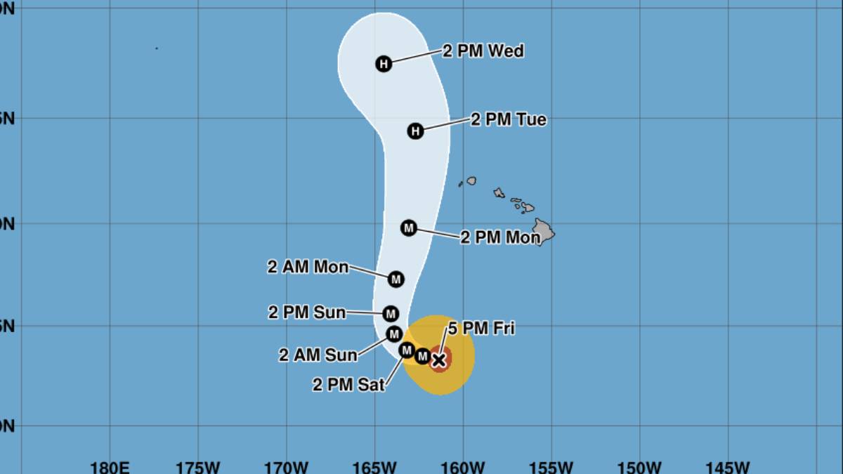
Updated at 5:30 p.m. Sept. 4
Lowell has regained strength Friday afternoon and now is a Category 5 hurricane, according to the 5 p.m. Friday advisory from the Central Pacific Hurricane Center.
“Interests in the Hawaiian Islands should monitor the progress of Lowell. Watches could be required for portions of the westernmost Hawaiian Islands on Saturday,” according to the advisory.
Hurricane Lowell is 615 miles south-southwest of Līhuʻe with maximum sustained winds of 160 mph. There are currently no coastal watches or warnings in effect.
As of 5 p.m. Friday, Lowell is moving west near 7 mph and is expected to gradually decrease in forward speed before taking a sharp turn to the north or northeast on Sunday.
High surf advisory
A high surf advisory remains in effect through 6 p.m. Saturday for south and southeast exposures of all islands.
Southerly swells from Hurricane Lowell will keep surf elevated above high surf advisory conditions through Saturday. A large, medium- period east swell is filling in from Hurricane Karina producing advisory level surf along east facing shores.
Large breaking waves are forecast to build up to 14 feet along east-facing shores, and 12 feet along south-facing shores. The swells will build up to 10 to 14 feet by Saturday, the National Weather Service advisory said.
Rainfall
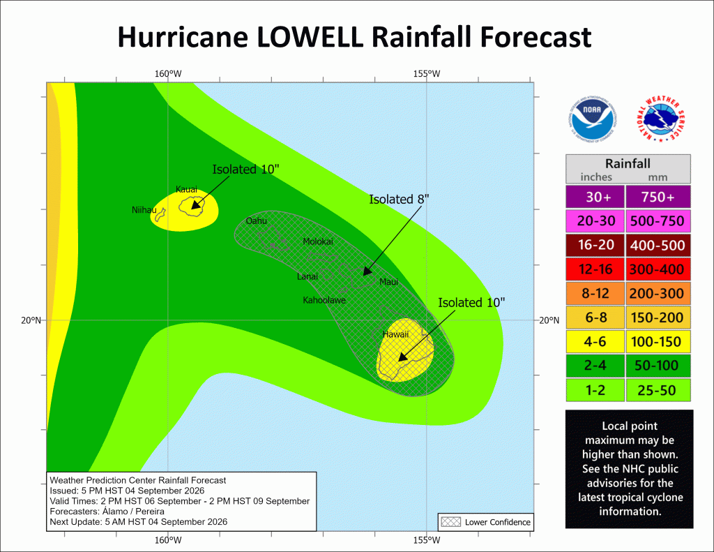
Residents across the state are being asked to seriously prepare for impacts from Lowell, which is forecast to produce rainfall totals of 3 to 6 inches, with maximum totals exceeding 10 inches specifically for Kauaʻi, Niʻihau and the Big Island.
This rainfall may produce flash flooding and mudslides, especially in areas of steep terrain.
“It should be noted that predicting where and how sharply Lowell turns is challenging, as it will depend on the location and amplitude of the mid- to upper-level low relative to the hurricane’s location,” according to the advisory.
Swells from Lowell are likely to cause life-threatening surf and rip current conditions during the next several days across many of the Hawaiian islands, including Kauaʻi and Niʻihau.
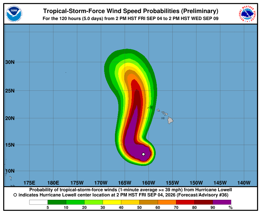
While it is still too soon to determine Lowell’s exact track, the hurricane could bring storm surge, wind and rainfall impacts to portions of Hawai‘i early next week, especially Kaua‘i County.
Winds are still expected to arrive by about 8 a.m. or shortly after Monday.
Swells generated by Lowell are likely to cause life-threatening surf and rip current conditions in parts of the state during the next several days and forecast to likely increase early next week.
The storm is bringing back memories for some Kauaʻi residents of the catastrophic Category 4 Hurricane ʻIniki, which in 1992 struck the island, killing seven people and doing an estimated $3 billion in damage.
“We need everyone on Kauaʻi to take this storm seriously and finish preparing now,” said Mayor Derek Kawakami. “Know where you will go if you need to leave your home, gather essential supplies and sign up for emergency alerts. Our county teams are ready, but preparedness begins with each household.”

Residents and visitors should monitor official forecasts, prepare emergency supplies, charge electronic devices, secure outdoor objects and avoid unnecessary travel as conditions worsen. Never drive, walk or swim through floodwaters.
Visitors should confirm flights, accommodations and activities directly with airlines, hotels and other providers. Visitor information is available at GoHawaii.com or by calling 1-800-GOHAWAII.
To receive county emergency alerts:
- Kauaʻi: Text KAUAIEMA to 888777
- Hawaiʻi Island: Text HAWAIIALERTS to 888777
- Maui County: Text MAUIALERTS to 38276
- Oʻahu: Text HNLALERT to 888777
Residents should continue following updates from the National Weather Service, Hawaiʻi Emergency Management Agency and their county emergency management agency.
Other Pacific storms
There also are two storms in the Eastern Pacific: Hurricane Karina and Hurricane Marie. Neither are not expected to present any severe weather impacts to the state; however, forecasters continue to monitor them closely.
The public should continue to monitor local radio broadcasts for official advisories, watches or warnings as well as forecasts for specific locations on the National Weather Service website.

