


We would bet the house that turnout would have been near 100% if a question on the Aug. 8 primary elections asked island residents if they wanted a near miss, close pass or, in the worst case scenario, a direct hit by a hurricane or other tropical cyclone within the next week.
We’d double down that the results would have been a nearly, if not, unanimous — and resounding — no.
Unfortunately, the weather doesn’t abide by Hawai‘i election rules and we don’t get to vote for what the atmosphere elects to spawn.
Nonetheless, the results are in and it again seems time to prepare to batten down the hatches and get storm ready as the National Hurricane Center and Central Pacific Hurricane Center — along with citizen forecaster and administrator of the Big Island’s Puna Weather public Facebook group Harry Durgin — concur that something wicked this way could be coming.
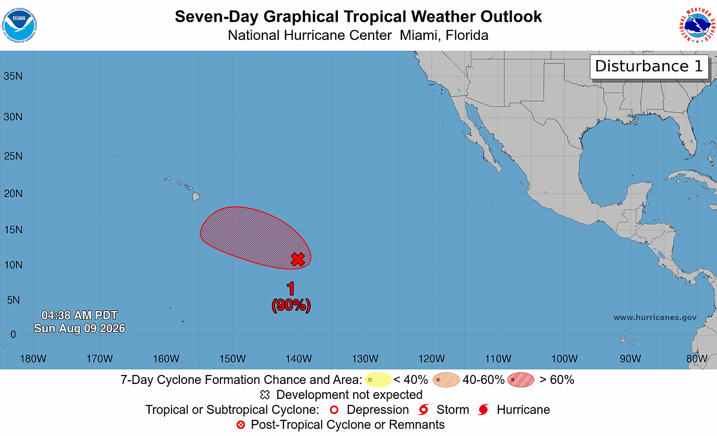
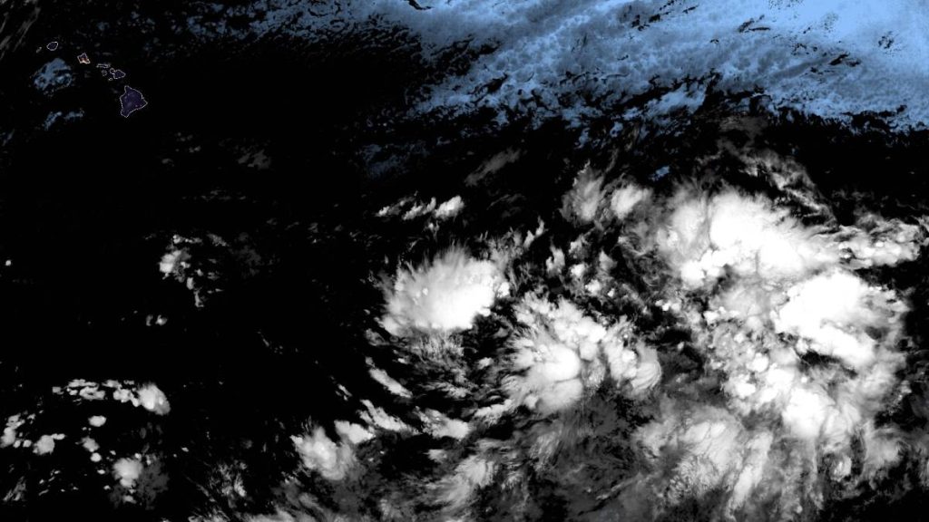
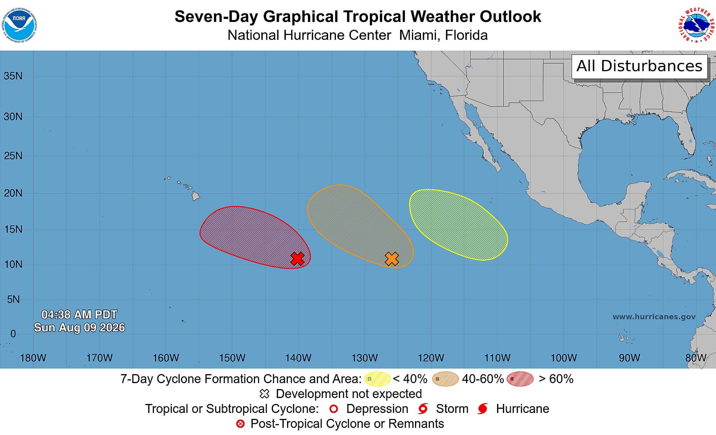
“A tropical wave located about 1,000 miles east-southeast of the Hawaiian Islands is producing disorganized showers and thunderstorms,” said the 2 a.m. Aug. 9 tropical cyclone update from the hurricane centers. “Environmental conditions are forecast to be conducive for further development, and a tropical depression is expected to form during the next few days while the system moves west-northwestward across the Central Pacific.”
While chances of the formation of a tropical cyclone — which can be a tropical depression, tropical storm or hurricane — are low through the next 2 days, at only 30%, a further look out shows a 90% chance of formation within the next 7 days.
“Possible hurricane next weekend!!!” Durgin said in his Aug. 8 weather update.
He said trouble is brewing to the southeast of the islands as the Madden-Julian Oscillation — an eastward-moving “pulse” of cloud and rainfall near the equator circling the globe every 30 to 60 days — passes through the Central Pacific Basin and vertical wind shear relaxes over the state.
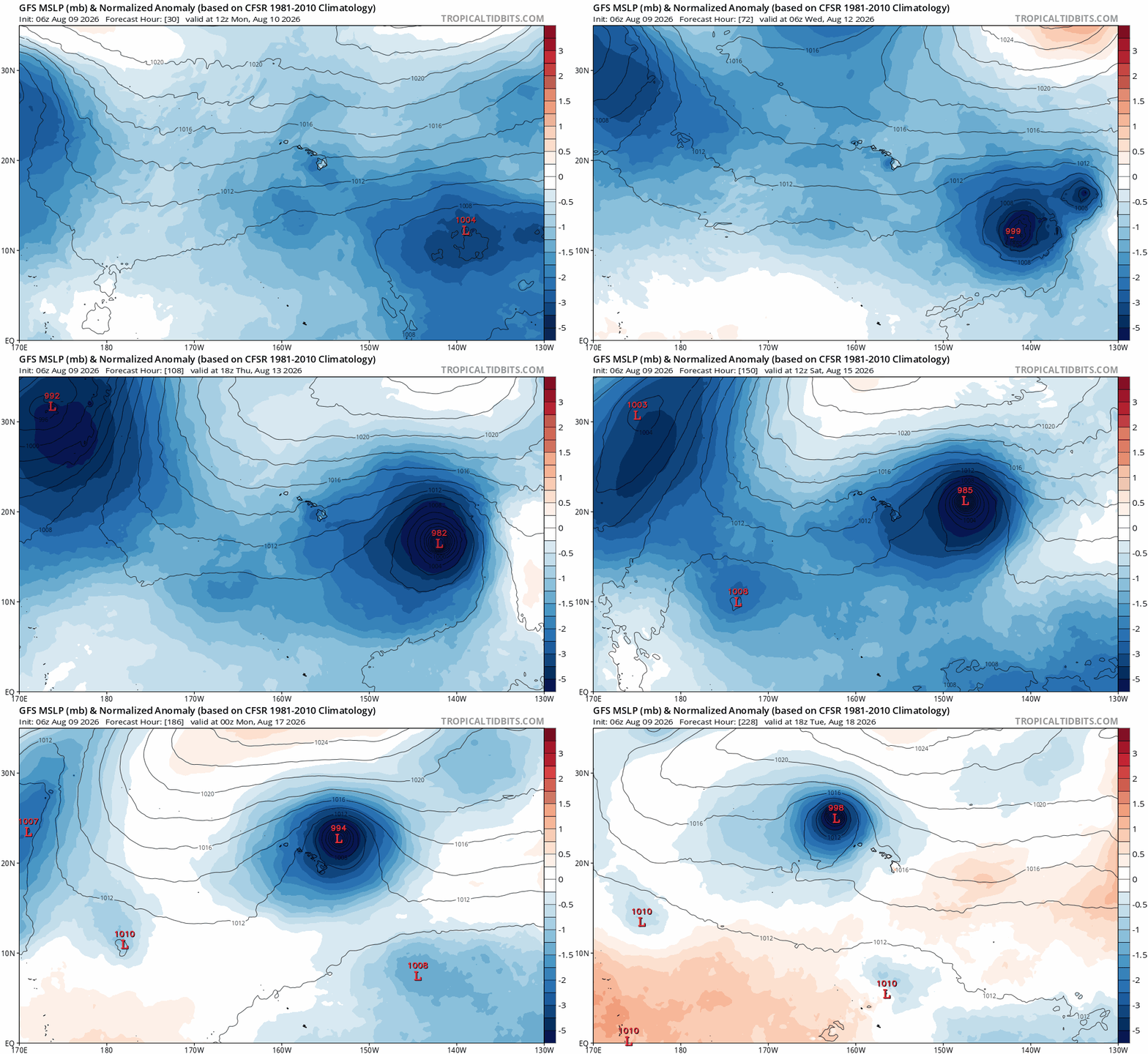
“Today we see multiple models leaning towards development of a low … ,” Durgin said. “Very warm sea surface temperatures this year could allow for a direct hit with [an] up-to-[Category 3] hurricane next weekend.”
The citizen forecaster said nothing is guaranteed, as it is still a full week out. So the possibilities of what can happen remain completely up in the air.
A storm “might not form, or remain week, or pass by to our south or east,” or cause “catastrophic damage,” Durgin said.
To make the situation even more tense and unsure is that another tropical wave located several hundred miles southwest of the southern tip of the Baja California Peninsula is also producing a large area of disorganized showers and thunderstorms.
Environmental conditions are forecast to be conducive for gradual development of that system, too.
“A tropical depression could form during the next few days while the system moves slowly west-northwestward to northwestward across the western portion of the East Pacific,” said the early Sunday morning tropical cyclone update from the hurricane centers.
Again, the chance of a tropical cyclone forming from that system during the next couple of days is low, at 30%, but jumps to a medium chance of 60% throughout the next week.
National Weather Service forecasters in Honolulu reported in their 8:25 p.m. Saturday area forecast discussion that breezy trades will focus low clouds and showers across windward and mauka areas of the state through the middle of this week.
A plume of moisture moving south of the islands will increase rain chances over the eastern end of the state through Aug. 10.
Durgin agreed, saying a weak low pressure system will pass to the south of the Big Island during the next few days with a large field of tropical moisture passing directly overhead, keeping conditions very humid with periods of heavy rain with light to moderate easterly trade winds through Monday for the east side of the Big Island, specifically Puna.
“Typical trade wind conditions return Tuesday through Thursday; nonetheless, very warm sea surface temperatures surrounding our island keep our air humid through this period,” Durgin forecasted.
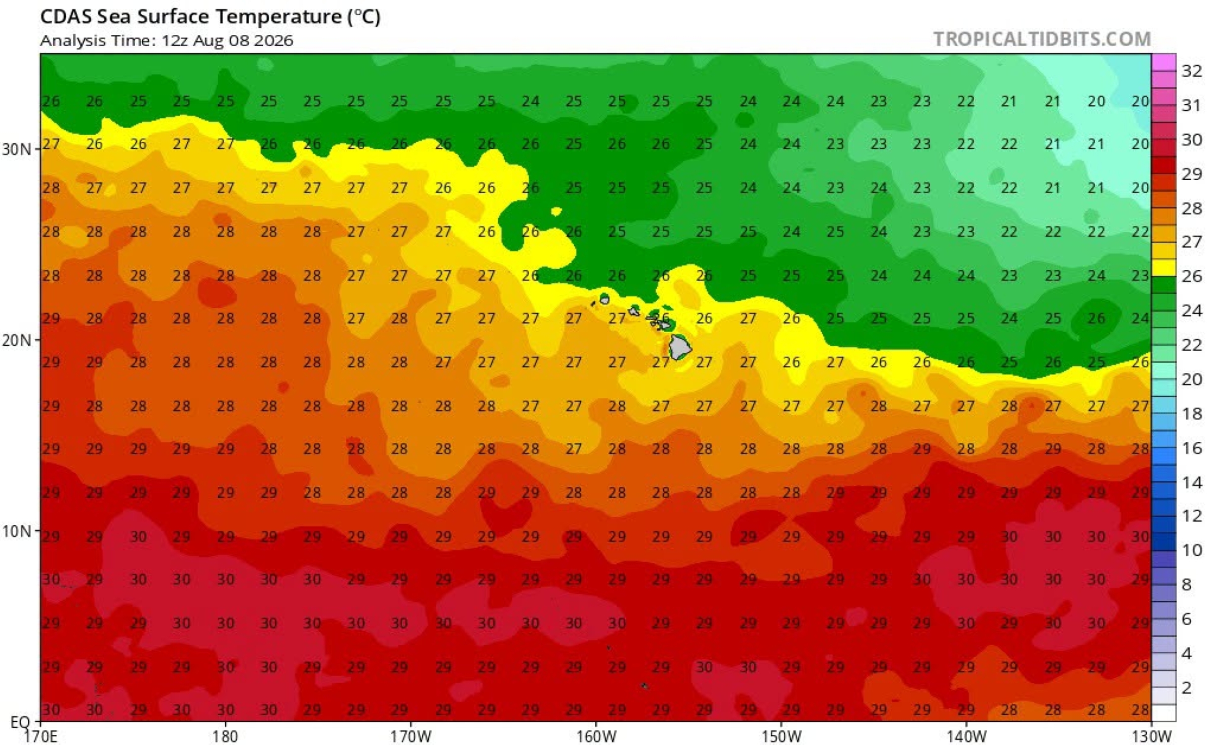
Those warm sea surface temperatures, while National Weather Service says somewhat drier conditions are expected from Aug. 11-13, will keep the possibility of scattered showers in the forecast for Puna and East Hawai‘i, with persistent light to moderate easterly trades.
Honolulu forecasters also warn that the brewing disturbances in the tropics need to be monitored for more organized development during the next several days.
“Friday through Sunday possible storm conditions … ,” Durgin said about the Aug. 14-16 period. “Stay tuned!”
He will be posting at least twice a day until after the risk passes.
“Please stay informed for the next week as models are likely to vary from day-to-day,” Durgin said.
Visit the National Hurricane Center and Central Pacific Hurricane Center website to keep track of tropical cyclone activity in the Central and East Pacific Basins.
Find your local forecast — along with any advisories, watches or warnings — at the National Weather Service Honolulu forecast office website.
Visit the Hawai‘i County Civil Defense website, Hawai‘i Emergency Management Agency website or National Weather Service website for information about how to prepare and be storm ready if — and when — a hurricane or other tropical cyclone threatens.

