


Editor’s note: This story was updated on July 26, 2026, at 5:09 p.m.
Hurricane Fausto is holding steady as it continues west across the Central Pacific.
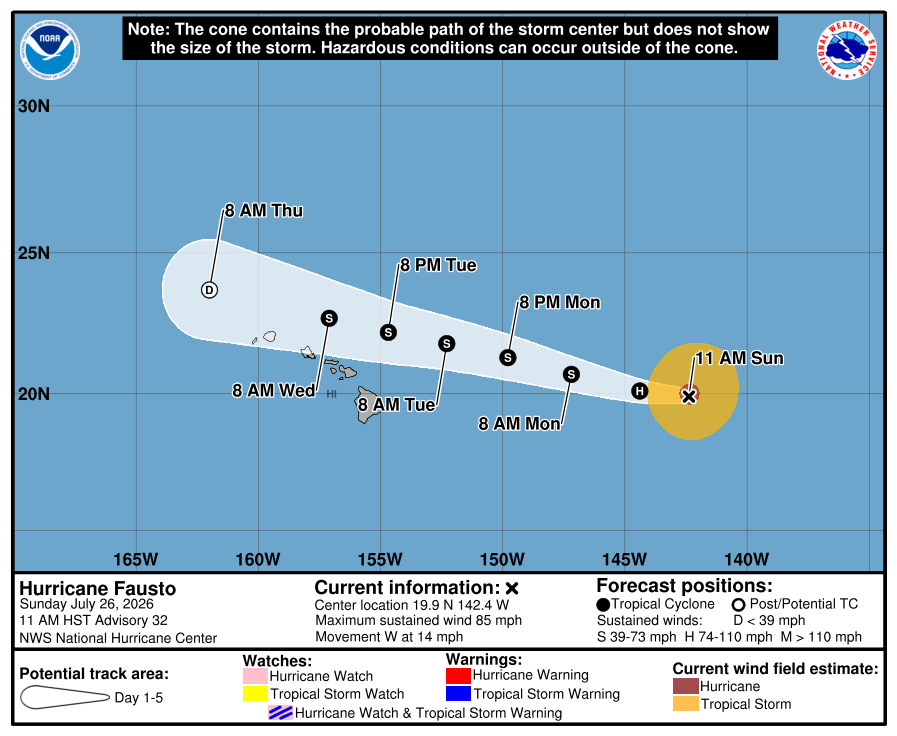
Hurricane Fausto entered the Central Pacific Basin early Sunday morning and is expected to weaken more as it approaches the Hawaiian Islands early this week.
According to the 5 p.m. advisory from the National Weather Service’s Hurricane Center, the hurricane was 740 miles east of Hawai‘i Island.
Fausto is moving west, gaining slightly in speed from 14 mph to 15 mph. Its maximum sustained winds have decreased from 90 mph to 85 mph.
Fausto is forecast to be a weakening tropical storm by the time it moves north of the Hawaiian Islands, with the deepest convection becoming increasingly displaced from the low-level center and strongest winds confined to the northern side of the circulation.
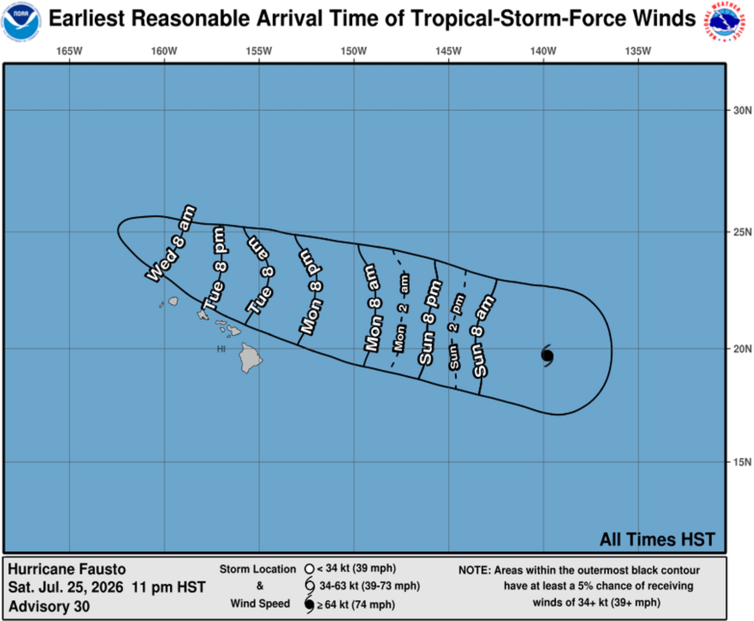
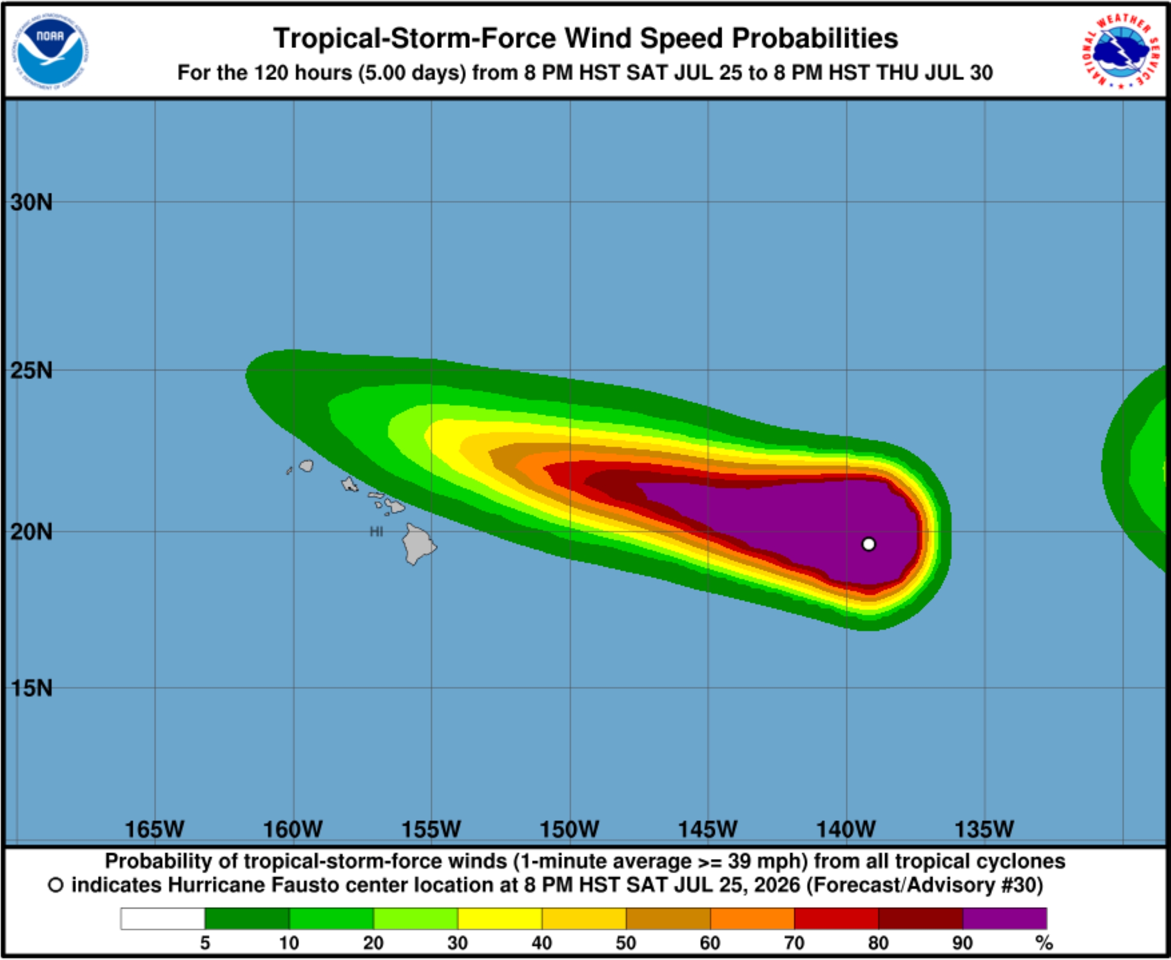
Based on predicted sheared nature of the storm, the risk of sustained tropical force winds on land should remain low as long as the forecast track stays north of the islands.
However, National Hurricane Center in Miami remains highly confident that swells generated by the hurricane will reach the state well in advance of the storm.
Those swells will produce increasing surf and dangerous rip currents. Surf is expected to steadily build westward throughout the islands during the next few days as Fausto approaches and passes to the north.
No coastal watches or warnings are issued, but forecasters advise the public and all stakeholders in Hawai‘i to continue monitoring the storm’s progress.
Hurricane-force winds extended outward up to 35 miles from the storm’s center, with tropical storm-force winds extending outward up to 150 miles.
Gradual weakening is forecast during the next several days.
Satellite imagery indicated Fausto’s convective structure had already begun to gradually deteriorate several hours before the 11 p.m. update on Saturday.
Mid-level dry air was increasingly being entrained into the hurricane’s circulation, resulting in the erosion of deep convection over its eastern semicircle. Recent microwave imagery also suggested erosion of portions of the eyewall.
Simulated satellite imagery is in agreement, depicting the storm’s convective structure gradually eroding late July 26 into early this week.
A strong subtropical ridge remains positioned north of the storm, and the latest track guidance is still in good agreement through the next 3 days, with some increase in cross-track spread thereafter as Fausto passes north of the Hawaiian Islands.
Additionally, southwesterly vertical wind shear is forecast to steadily increase beginning during about the next day.
A U.S. Air Force Reserve Hurricane Hunter aircraft and National Oceanic and Atmospheric Administration aircraft are scheduled to investigate Fausto on Sunday. The reconnaissance data should help improve confidence in the storm’s subsequent track and intensity forecasts.
Shipping firm Young Brothers is keeping a close eye on Fausto, reporting Saturday afternoon it had not changed any shipping schedules. However, it anticipate increased harbor surge caused by Fausto could cause potential delays or impede the company’s ability to safely berth, ramp or discharge barges.
U.S. Coast Guard also set Port Heavy Weather Condition Whiskey for all commercial ports throughout Hawaiʻi, effective as of 8 p.m. July 24 because of possible gale force winds generated by Fausto during the next several days.
Port facilities are open to all commercial traffic and all transfer operations can continue, however:
- All pleasure craft shall seek sheltered waters.
- Operators of vessels 200 gross tons and greater should plan to depart port. The ports captain might direct departures to reduce the number of vessels in port.
- Vessels that desire to remain in port must submit a safe mooring plan and receive written permission from the ports captain and Hawaiʻi Department of Transportation Harbors Division.
- Requests should be submitted immediately. Requests received after Port Condition X-Ray might not be considered. Send requests to D14-DG-SH-SecHono-MTSRU@uscg.mil and HawaiiDistrict.heavyweather.request@hawaii.gov.
- Vessels transiting within the vicinity of the Hawaiian Islands should seek sheltered waters and anticipate additional restrictions and possible port closures as conditions progress.
- The ports captain can restrict operations of or deny port entry to vessels transporting oil or certain hazardous materials.
- If and when Port Condition Yankee is set because sustained tropical storm force winds of 39 mph are expected within 24 hours, ports are closed to incoming traffic without specific approval from the ports captain.
Contact the Maritime Transportation System Recovery Unit via email at D14-DG-SH-SecHono-MTSRU@uscg.mil or U.S. Coast Guard Sector Honolulu Command Center at 1-800-552 6458 for additional information and questions about port services and closings.
National Weather Service forecasters in Honolulu and Hawai‘i County officials urge the public to prepare regardless of potential impacts and storm track.
They offered several preparation pointers:
- Check your emergency kits and fill up on supplies — 14 days of food, water and medication.
- Check in with family and friends: How you will get in contact and where you will go during an emergency or evacuation?
- Know your zone: Check if you are in a flood prone area or exposed to strong winds.
- Prepare your home: Trim trees, clean gutters, seal gaps, bring in loose outdoor items.
Check insurance policy and have information handy.
Kaua’i County Mayor Derek Kawakami, while there is no immediate threat from Fausto, asks everyone on the Garden Isle to be prepared.
County officials encourage every household to:
- Maintain a 14-day supply of food, water, medication and other essentials.
- Prepare a portable disaster supply “go kit.”
- Keep important documents in a waterproof container.
- Understand the hazards that could affect their home or neighborhood.
- Review potential refuge options.
- Make arrangements in advance for pets, kūpuna and family members with access or functional needs.
Preparation is key to limit any impacts from a tropical cyclone, and it seems Fausto could just the beginning.
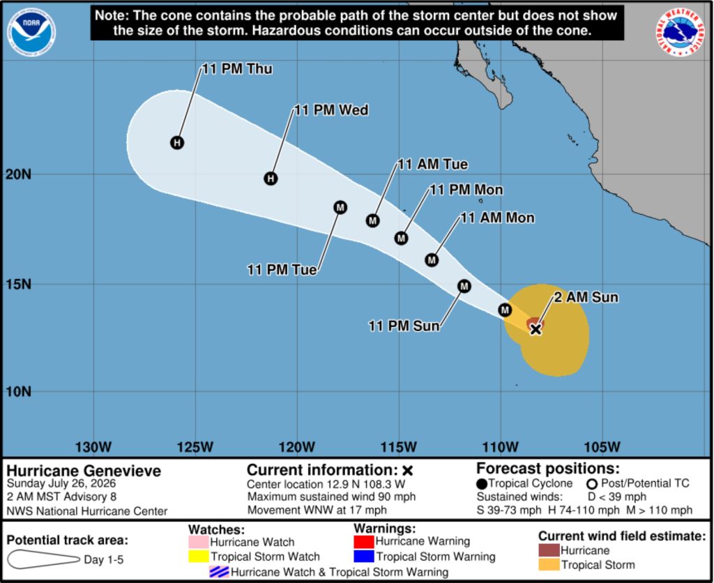
What was Tropical Storm Genevieve is rapidly intensifying in the East Pacific Basin, becoming a hurricane Saturday. National Hurricane Center also expects that rapid intensification to continue, with the storm forecast to become a major hurricane later Sunday.
Genevieve was located about 500 miles south-southwest of Manzanillo, Mexico, with sustained winds of 90 mph and moving west-northwest at about 17 mph by 11 p.m. Saturday. Some decrease in forward speed is expected, however, during the next few days.
Recent satellite-derived wind data indicated hurricane force winds extended outward up to 40 miles from the storm’s center, with tropical storm force winds extending up to 195 miles.
Gradual weakening is likely to begin after the next 2 days as Genevieve encounters cooler sea-surface temperatures and a drier and more stable environment. However, the tropical cyclone is forecast to remain a hurricane through the end of this week.
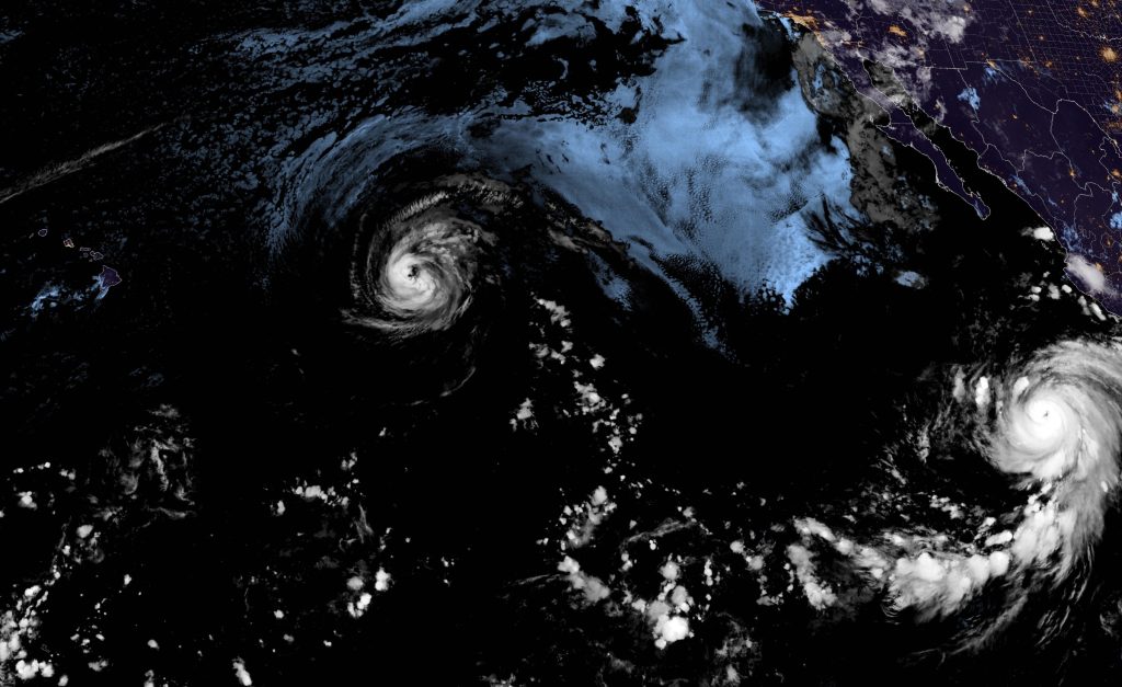
 A wider view of a National Weather Service satellite image from early the morning of July 26, 2026. You can see the Hawaiian Islands on the left side of the image, with Hurricane Fausto pretty much directly east of the state and rapidly intensifying Hurricane Genevieve farther southeast on the right side of the image.
- Courtesy Graphic: National Hurricane Center
A high surf advisory for south-facing shores of the entire state — unrelated to Hurricane Fausto — also was extended again until 6 a.m. Sunday, with large breaking waves of 7 to 10 feet and strong currents continuing to make swimming and other recreational ocean activities dangerous along those shores.
Additional updates will be provided as Fausto continues to spin toward Hawai‘i.

