


“Volcano Watch” is a weekly article and activity update written by U.S. Geological Survey Hawaiian Volcano Observatory scientists and affiliates.
Hawaiian Volcano Observatory staff are often asked, “Will lava erupted during the ongoing Kīlauea summit eruption in Halemaʻumaʻu eventually flow out of the caldera? And if so, when?”
The answer is — complicated.
Topography of Kaluapele, Kīlauea volcano’s summit caldera, is stepped — a series of ledges at different elevations. The deepest part — now covered by lava flows from the ongoing episodic eruption in Halemaʻumaʻu that began in December 2024 — collapsed downward in 2018.
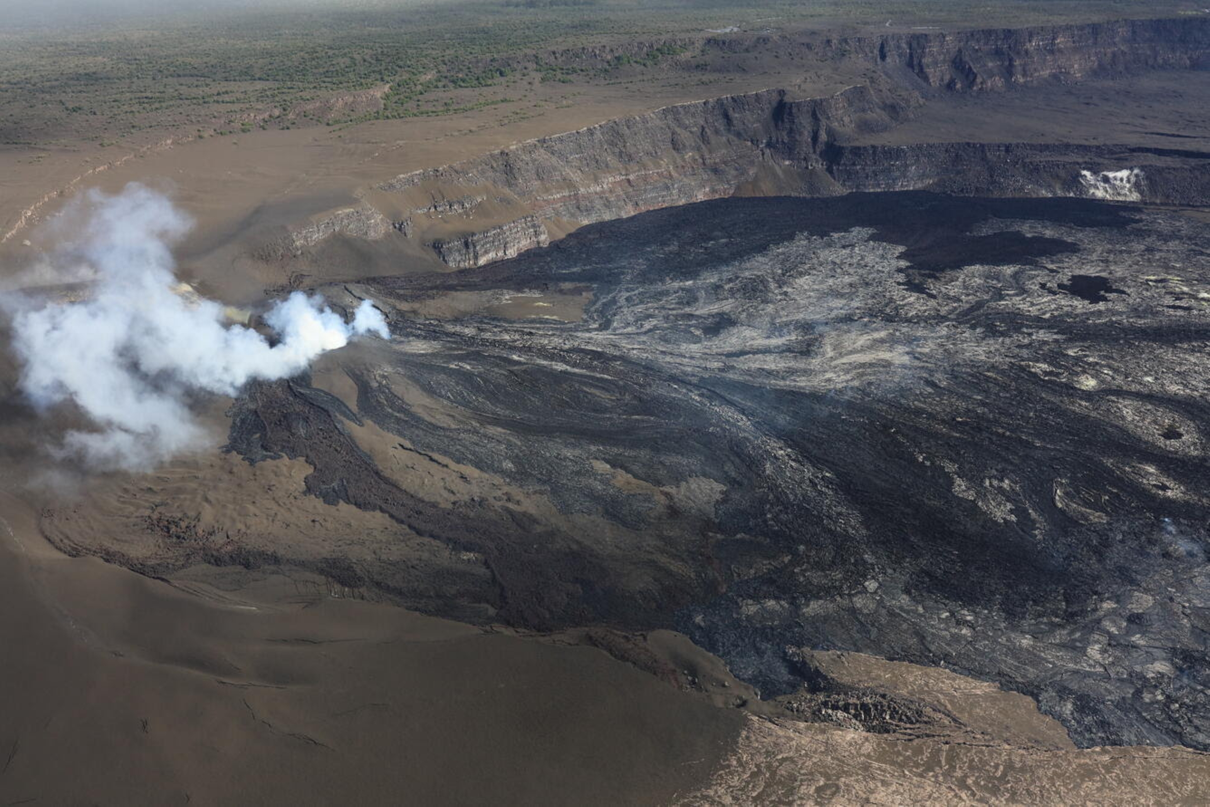
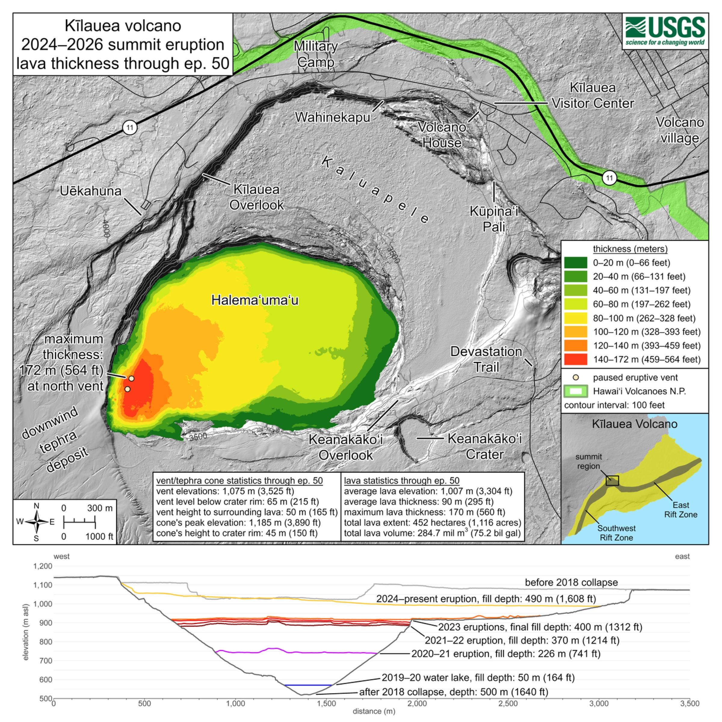
Volume of what was left within the caldera after the 2018 collapses was about 0.20 cubic miles and the bottom of Halemaʻumaʻu Crater settled at an elevation of 1,696 feet above sea level.
That means the base of Halemaʻumaʻu after the 2018 collapse was 2,395 feet lower than Uēkahuna Bluff — the highest point on Kīlauea at an elevation of 4,091 feet.
Five eruptions within Halemaʻumaʻu between 2020 and 2023 filled in about 25% of the 2018 collapse volume, raising the crater floor by 1,313 feet to an elevation of 3,009 feet.
An additional 35% of the 2018 collapsed volume was filled in by the ongoing fountaining eruption during the past year and a half, and the crater floor is an additional 295 feet higher.
However, the ongoing eruption has filled in less depth because the 2018 collapsed area was cone shaped, so the deepest part filled the fastest during the first five eruptions after 2018 and required less volume of lava to do so.
Lava flows during the ongoing episodic eruption covered a much larger area — 1,116 acres — and therefore accrue thickness more slowly.
A total of 60% of the 2018 collapsed volume has been filled in, raising the crater floor by 1,608 feet. Assuming the ongoing summit eruption continues at the same rate is has during the past year — 0.04 cubic miles — for the next year and a half, the 2018 collapse area could be almost totally filled by early 2028.
Once the 2018 collapsed area fills in, lava will flow onto the east part of the main caldera floor.
The last time lava flowed here was more than 50 years ago when a series of fissures on the south caldera rim and floor opened in July 1974, erupting lava that covered the southern portion of the caldera floor.
Once lava flows onto the caldera floor, it has a much bigger area to cover: 2,500-plus acres, so it will take even longer to accrue thickness.
The volume required to fill the main caldera is difficult to calculate because it is topographically “breached” to the southwest, meaning lava will spill out this way before reaching the taller rim on the north side.
But since effusive volcanoes always deposit more lava closer to its sources, they build up shields that eventually overcome the local topography.
In any case, at least another 0.22 cubic miles is required to fill the caldera, which at current rates would take an additional 5 years.
Also remember, as fountaining episodes at the summit have demonstrated, eruption rates vary with time.
Some episodes erupted more lava than others, particularly those during which the north and south vents produce fountains. Other episodes, with only one vent erupting at a lower height, produce less lava.
This variability makes all of our filling forecasts very rough estimates.
Another important factor to consider is the elevation of the vents within Halemaʻumaʻu, which remain 215 feet lower than the crater rim.
If the vents grow above the crater rim, this also could send lava downslope to the southwest within Hawai’i Volcanoes National Park, where it would pose no threat to communities.
Lava will always flow in the downslope direction, but since the emplacement of flows will continue to change the vent geometry and local topography, they could also remain within the caldera.
The easiest answer to the question of whether lava will flow out of the caldera is — it depends!
It depends on how long this eruption continues, what rate lava erupts through time and where it builds up the area around the vents.
While there is no sign of this eruption changing, it also depends on whether eruptive activity at Kīlauea changes, as a new eruption beginning elsewhere is always a possibility.
* * * * * * * * *
VOLCANO ACTIVITY UPDATES
KĪLAUEA volcano
VOLCANO ALERT LEVEL: Advisory
Kīlauea has erupted episodically since Dec. 23, 2024, within Halema’uma’u Crater in Kaluapele, the volcano’s summit caldera, confined to Hawai’i Volcanoes National Park.
Episode 51 of summit lava fountaining happened for 8.3 hours July 15. No unusual activity has been noted along Kīlauea’s East Rift Zone or Southwest Rift Zone.
WHAT’S NEXT: Summit region inflation since the end of Episode 51 indicates another fountaining episode is possible, but more time and monitoring data is needed to develop a forecast.
MAUNA LOA volcano
VOLCANO ALERT LEVEL: Normal
Mauna Loa is not erupting. Read the latest monthly activity update from July 2 for additional information about what’s happening at Mauna Loa.
Hawaiian Volcano Observatory continues to closely monitor Kīlauea and Mauna Loa.
* * * * * * * * *
EARTHQUAKE ACTIVITY
Four earthquakes were reported felt during the past week in the Hawaiian Islands:
- MAGNITUDE-2.4 earthquake at 8:27 p.m. July 13 located just to the south-southeast of Pa‘auilo at a depth of 6 miles.
- MAGNITUDE-3.0 earthquake at 10:45 a.m. July 11 located 10 miles south-southwest of Hōnaunau-Nāpōʻopoʻo at a depth of 10 miles.
- MAGNITUDE-3.1 earthquake at 9:25 a.m. July 10 located 4 miles south of Hōnaunau-Nāpōʻopoʻo at a depth of 11 miles.
- MAGNITUDE-4.5 earthquake at 8:17 p.m. located 35 miles west-southwest of Captain Cook at a depth of 24 miles.
Visit the Hawaiian Volcano Observatory website for past “Volcano Watch” articles, Kīlauea and Mauna Loa updates, volcano photos, maps, recent earthquake information, and more. Email questions to askHVO@usgs.gov.

