

Scientists for decades worked to improve predictions of El Niño-Southern Oscillation, or ENSO, a climate powerhouse that can cause droughts, flooding, marine heatwaves and more around the world.
Now, University of Hawai‘i at Mānoa researchers recently published a study showing they can skillfully predict El Niño and La Niña 15 months ahead of time using only observations of ocean surface temperature and height — no complex climate model needed.
“Accurately predicting ENSO more than a year in advance is important because it can provide early warning, allowing communities, governments and resource managers to take actions and make adaptations to reduce the potential impacts from El Niño and La Niña,” said study lead author and postdoctoral researcher at University of Hawai‘i at Mānoa Sea Level Center in School of Ocean and Earth Science and Technology Yuxin Wang in a release about the new findings.
Wang added that the simpler, data-driven empirical climate model, built only from ocean observations related to two core climate memories known for more than 50 years, achieves El Niño-Southern Oscillation forecast skill comparable to, and in some cases better than, many of today’s more complex climate models and leading artificial intelligence-based approaches.
Klaus Wyrtki, a pioneering oceanographer at School of Ocean and Earth Science and Technology from the 1960s through 1990s, was the first to show that sea level changes can reveal heat build-up in the tropical Pacific Ocean, which led him to propose using tide gauge observations to predict El Niño.
Klaus Hasselmann, a German oceanographer and Nobel laureate, showed that the ocean can retain a memory of past climate conditions through large-scale temperature patterns, including sea surface temperature patterns outside the tropical Pacific that can still influence El Niño-Southern Oscillation.
Building on these two principles, the University of Hawai‘i at Mānoa team developed the “Wyrtki-CSLIM,” short for Wyrtki CycloStationary Linear Inverse Model, a computer model to predict El Niño-Southern Oscillation.
The team trained their model using ocean observations that correspond directly to the two forms of climate memory originally suggested by Wyrtki and Hasselmann.
The first is sea level in the equatorial Pacific, which reflects heat stored in the upper-ocean and represents “Wyrtki memory.” The second is global sea surface temperature, which captures “Hasselmann memory,” or the lingering influence of faraway ocean temperature anomalies that can contribute to El Niño or La Niña developing months later.
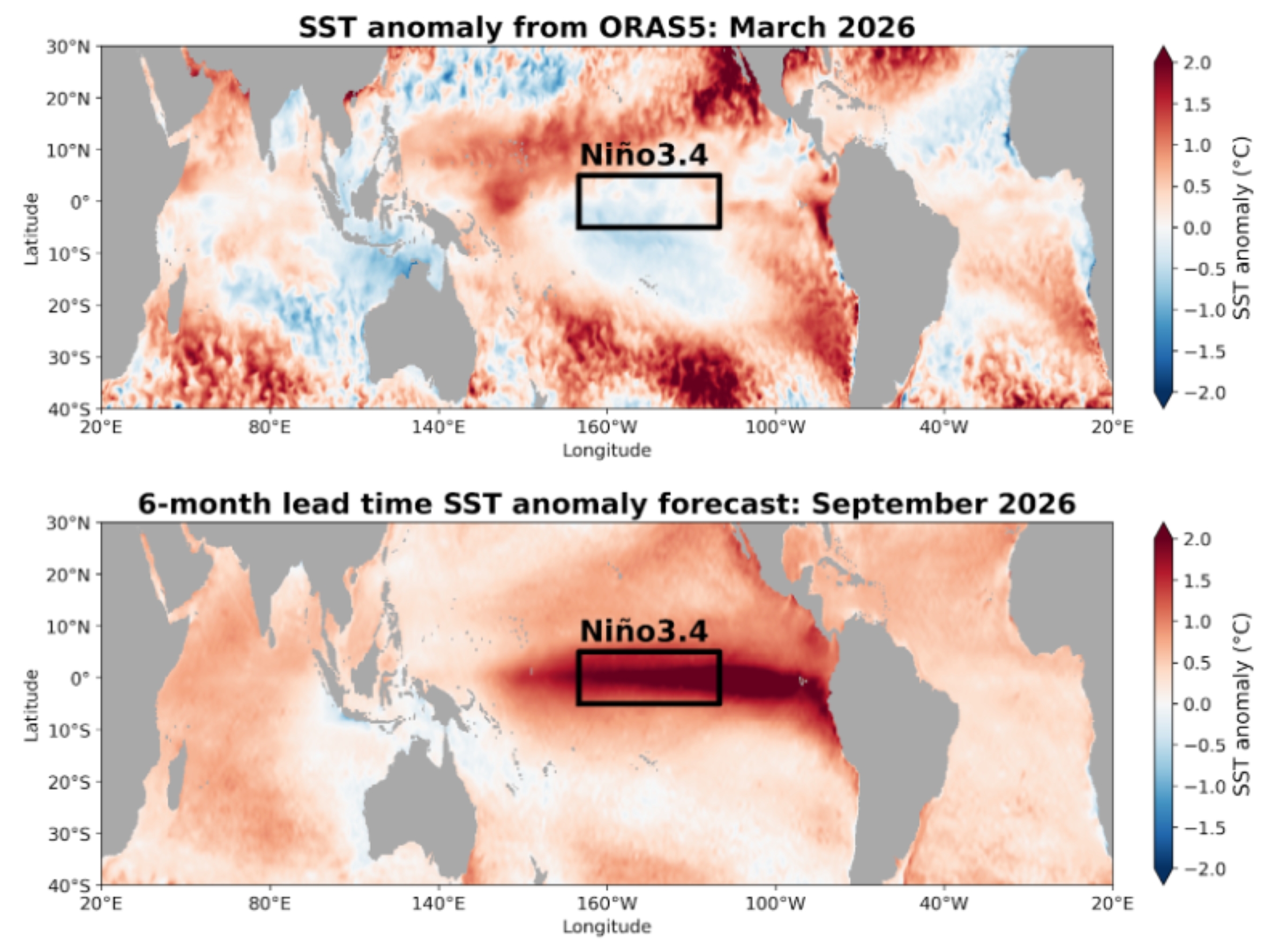
The researchers tested how well this model could predict the Niño 3.4 index, a standard measure used to track El Niño and La Niña.
They ran the model on 6 decades of past climate conditions to do that, and asked how well it would have predicted what happened next in the real world.
The Wyrtki-CSLIM predicts the development of a strong El Niño, more than 35.6 degrees warmer than normal over the equatorial eastern Pacific, toward the end of this year.
This up-to-date forecast is available online at the Sea Level Center website.
This new research also offers a clear direction for other El Niño-Southern Oscillation forecasting systems.
“Our Wyrtki model is predicting a stronger El Niño than most of the other statistical models, and it is in line with the much more sophisticated dynamical models,” said study co-author and associate director of the Sea Level Center Matthew Widlansky in the release. “However, it is important to note that all models have uncertainties, and the climate impacts of each El Niño event are different.”
