

UPDATE 2: High surf advisory now in effect through Thursday for north, west shorelines of Kauaʻi, Niʻihau
Update at 4:02 a.m. Thursday, Feb. 5, 2026: A high surf advisory is now in effect until 6 p.m. today (Feb. 5) for north and west shorelines of Kaua‘i and Ni‘ihau, replacing a previously issued high surf warning.
The northwest swell impacting the state is on the downward trend and will continue to slowly lower today. Surf has dropped below warning levels, triggering the earlier warning to be canceled and a downgraded advisory put in its place.
Forecasters at the National Weather Service Honolulu office report surf along north- and west-facing shores of most islands should hold at advisory levels through much of the day.
Northern shores are expected to see surf of 15 to 20 feet to start the day, lowering to 10 to 14 feet by late this afternoon. Western shores of the smaller islands — including Kaua‘i and Ni‘ihau — should expect surf of 10 to 14 feet, falling to 6 to 8 feet by late this afternoon.
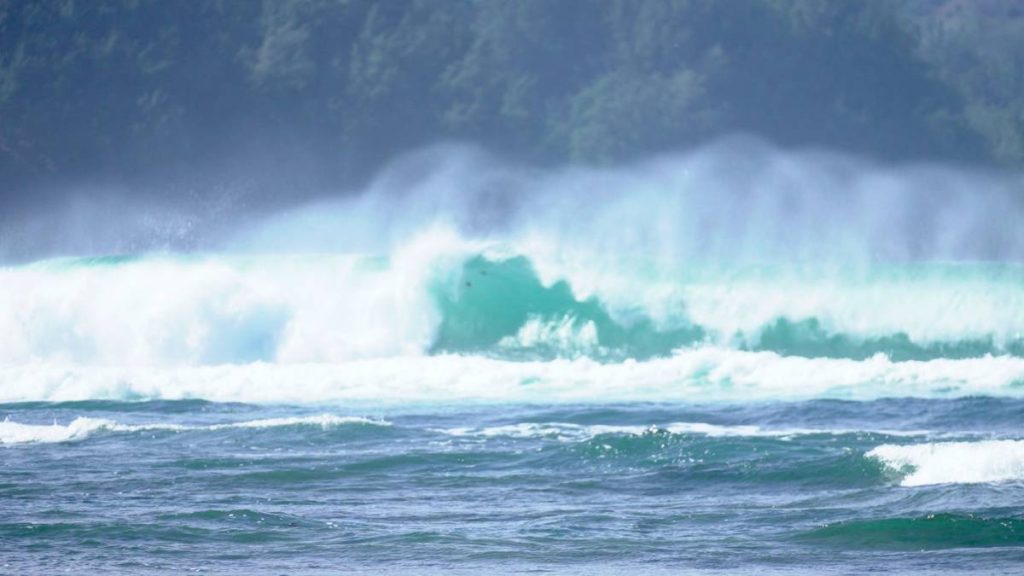
Strong breaking waves and strong currents will continue to make swimming and other ocean activities in the advisory areas dangerous.
Heed all advice from ocean safety officials — when in doubt, don’t go out.
3:40 p.m. Feb. 4 update: The National Weather Service has extended the high surf warning for north- and west-facing shores of Kaua‘i and Ni‘ihau through 6 a.m. Thursday.
According to forecasters, the extra large northwest swell is now declining, however, surf along exposed north and west facing shores of Kaua‘i and Ni‘ihau will remain at warning levels this evening and tonight.
Surf heights along north-facing shores are projected to reach 20 to 30 feet this evening before lowering to 20 to 25 feet by Thursday morning. Surf heights along west-facing are projected to reach 15 to 20 feet.
Beachgoers are also advised to use extreme caution, as large breaking waves could make it dangerous for those standing along the shoreline. Entering the water in these areas during the high surf warning is very hazardous and could cause serious injury or death, according to the Kauaʻi Ocean Safety Bureau.
For updated information on ocean and weather alerts, visit the National Weather Service website.
For current information about Kaua‘i ocean conditions and ocean safety, speak to a county lifeguard at any lifeguard station or visit the Ocean Safety Bureau website.
Original post: A high surf warning for north- and west-facing shores of Kaua‘i and Ni‘ihau is in effect through 6 p.m. Wednesday, as a powerful northwest swell moves into the islands, according to forecasters at the National Weather Service in Honolulu.
Forecasters said surf is expected to rise rapidly along exposed coastlines Monday evening, with wave heights peaking Tuesday, Feb. 3, well above warning thresholds.
An unusually large northwest swell, combined with overlapping wave pulses, is expected to keep surf elevated through Wednesday before conditions gradually improve along north-facing shores. Wave heights are forecast to reach 20 to 30 feet overnight, building to 30 to 45 feet by Tuesday afternoon, according to the weather service.
West-facing shores are expected to see surf increase from 15 to 20 feet to 20 to 30 feet during the same period. Officials warned that ocean conditions during the advisory period will be extremely dangerous.
Entering the water could result in serious injury or death, and beachgoers were urged to remain cautious, as large breaking waves may also pose hazards along the shoreline.
The warning may be extended, modified, or canceled depending on changing conditions. Residents and visitors are encouraged to monitor updates from the National Weather Service and consult county lifeguards for the latest information on ocean safety and beach conditions.
For updated information on ocean and weather alerts, click here.
Sponsored Content
