

December was wetter, but 2025 was pretty dry overall for Garden Isle
A wetter December on Kauaʻi was a significant improvement from a relatively dry November, with the National Weather Service reporting in its monthly rainfall summary that nearly all locations around the island saw near to above average rainfall for the month.
A few even collected almost double their normal amounts.
Much of that rainfall came during the most significant weather event of the month near the middle of December, when a stronger front approached on Dec. 12, bringing breezy south to southwest winds and pre-frontal showers.
The front moved over Kauaʻi and Oʻahu on Dec. 13-14 before stalling and retrograding westward through Dec. 15.
A shortwave trough destabilized the atmosphere through the Dec. 20 — after a brief lull Dec. 16 — leading to another extended period of steady rainfall over Kauaʻi and Oʻahu.
Combined rainfall totals from that system were about 3 to 6 inches on Kauaʻi, with localized totals of up to 7 inches.
The U.S. Geological Survey rain gauge on Mount Waiʻaleʻale, yet again, had the highest monthly total for the island of 31.47 inches, 105% of its monthly average for December. It also collected the highest daily total for the island — and state — for December with 6.58 inches on Dec. 23.
Other rainfall totals of note for the month included:
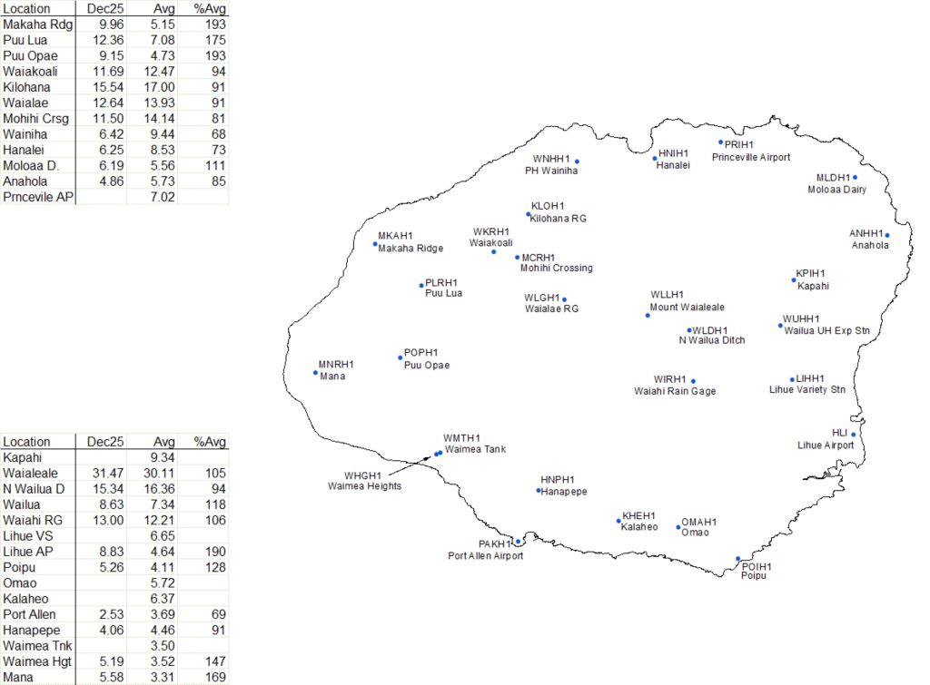
- Kilohana: 15.54 inches (91% of normal 17 inches).
- North Wailuā Ditch: 15.34 inches (94% of normal 16.36 inches).
- Waiahi Rain Gauge: 13 inches (106% of normal 12.21 inches).
- Waiʻalae: 12.64 inches (91% of normal 13.93 inches).
- Puʻu Lua: 12.36 inches (175% of normal 7.08 inches).
- Waiakoali: 11.69 inches (94% of normal 12.47 inches).
- Mōhihi Crossing: 11.5 inches (81% of normal 14.14 inches).
Locations receiving nearly double the amount of their normal December precipitation, including the above Pu‘u Lua, were:
- Makaha Ridge: 9.96 inches (193% of normal 5.15 inches).
- Puʻu ʻŌpaʻe: 9.15 inches (193% of normal 4.73 inches).
- Līhuʻe Airport: 8.83 inches (190% of normal 4.64 inches).
- Mana: 5.58 inches (169% of normal 3.31 inches).
As for the year, aside from a few significant rain events, 2025 was pretty dry for Kauaʻi.
Only a handful of sites ended the year above average. The remainder of the island saw below average rainfall for 2025 — generally near or below 85%.
The southern coast fared the worst, with just about half of the usual yearly rainfall.
Some sites also were taken offline because of maintenance issues for the past few months of the year, resulting in no year-to-date amounts being available.
The Mount Waiʻaleʻale rain gauge again took the top spot for annual rainfall on Kauaʻi as well as statewide with 319.65 inches.
Some might be surprised that much rain collected on the mountain still didn’t reach its annual average. The site was still 81% of its annual average — which is a whopping 393.85 inches.
Other significant amounts of rainfall — 100 inches or more — around the island throughout 2025 were recorded at:
- North Wailuā Ditch: 161.66 inches (84% of normal 191.66 inches).
- Kilohana: 149.66 inches (91% of normal 164.16 inches).
- Waiahi Rain Gauge: 125.8 inches (89% of normal 141.57 inches).
Locations that received their annual average amount of rainfall or more were:
- Molaʻa Dairy: 52.78 inches (103% of normal 51.21 inches).
- Hanalei: 96.95 inches (112% of normal 86.36 inches).
- Mana: 23.25 inches (115% of normal 20.23 inces).
- Makaha Ridge: 43.6 inches (120% of normal 36.27 inches).
- Puʻu ʻŌpaʻe: 40.39 inches (125% of normal 32.34 inches).
 Kauaʻi rainfall totals for December 2025. (Graphic Courtesy: National Weather Service Forecast Office Honolulu)
- Kauaʻi annual rainfall totals for 2025. (Graphic Courtesy: National Weather Service Forecast Office Honolulu)
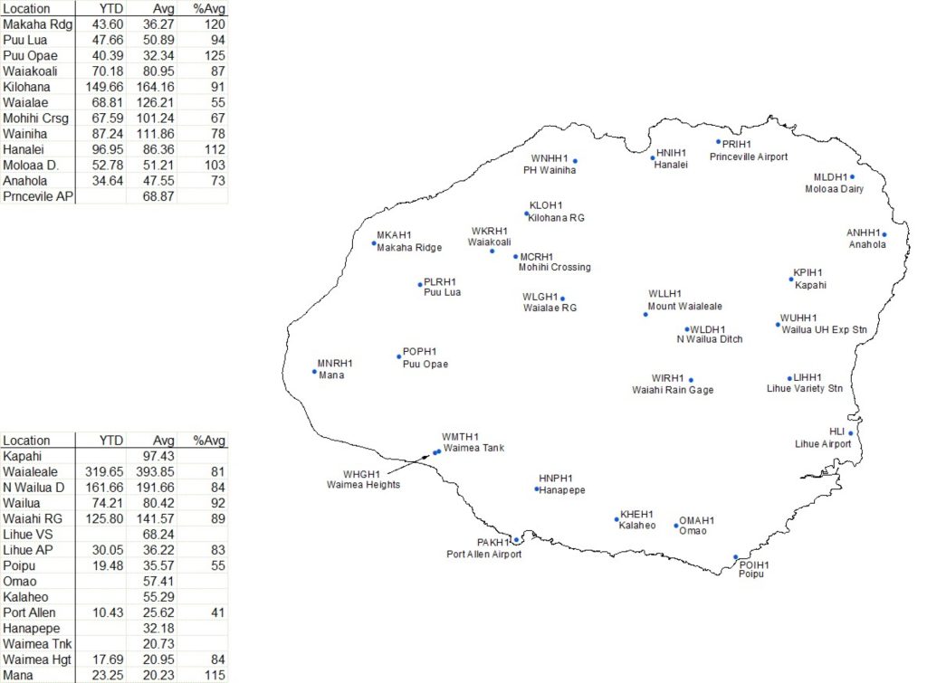
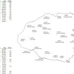
Port Allen was the only location around Kauaʻi that reported less than half of its annual rainfall average for 2025, collecting 10.43 inches for the year, which is 41% of its annual norm of 25.62 inches.
Poʻipū, with 19.48 inches for all of 2025 and Waiʻalae, with 68.81 inches of rain last year collected just more than half their normal annual average rainfall at 55%. Poʻipū’s annual norm is 35.57 inches and Waiʻalae’s is 126.21 inches.
December began with dry and stable conditions throughout the state, as light southeasterly winds and localized land and sea breezes prevailed ahead of an approaching front.
That weak front stalled near Kauaʻi on Dec. 3, bringing showers embedded in southerly flow to Kauaʻi and Niʻihau into Dec. 4.
High pressure rebuilt northeast of the state as the front retreated back to the west, allowing east to east-southeasterly trade winds to strengthen, with typical scattered windward and mauka showers.
Winds weakened and veered southeasterly to southerly again by about Dec. 8-9 as another front approached. That front brought a wetter pattern statewide through Dec. 11, followed by cooler northerly winds in its wake.
Then the stronger mid-month front that proved to be the most significant weather-maker of December moved over the islands, with trade winds returning from Dec. 21-23, bringing more stable conditions.
Moisture from a remnant front was pushed south during that period, enhancing showers along windward slopes, producing rainfall of about 1 to 2 inches on most islands.
Drier and locally breezy trades prevailed through Christmas Eve and Christmas Day, followed by weakening winds and a shift back toward an east-southeasterly direction ahead of another front.
The month ended with moderate trades and generally dry conditions, despite a brief surge of moisture the morning of Dec. 30 that slightly enhanced windward showers.
No significant impacts were reported.
The monthly rainfall summary was prepared by National Weather Service Forecast Office Honolulu Senior Service Hydrologist Tina Stall.
News reporter Nathan Christophel contributed to this story.
Sponsored Content
