

“Volcano Watch” is a weekly article and activity update written by U.S. Geological Survey Hawaiian Volcano Observatory scientists and affiliates.
The largest Hawaiʻi earthquake of the 20th century and so far in the 21st century happened 50 years ago this month.
Shaking as well as ground subsidence and a local tsunami contributed to a catastrophic sequence of events Nov. 29, 1975.
Named the “Kalapana earthquake” for its epicenter near Kalapana on the southeast side of Hawaiʻi Island, the earthquake struck at a depth of about 5 miles.
It was preceded by small foreshocks — several in the 4 to 5 magnitude range — that started a month before the mainshock. The largest foreshock was a magnitude-5.7 quake at 3:36 a.m. Nov. 29, 1975 — the same day as the historic quake.
The massive magnitude-7.7 temblor struck at 4:48 a.m., just more than an hour later.
Shaking lasted more than 30 seconds and was felt around the island and as far as Maui and O‘ahu.
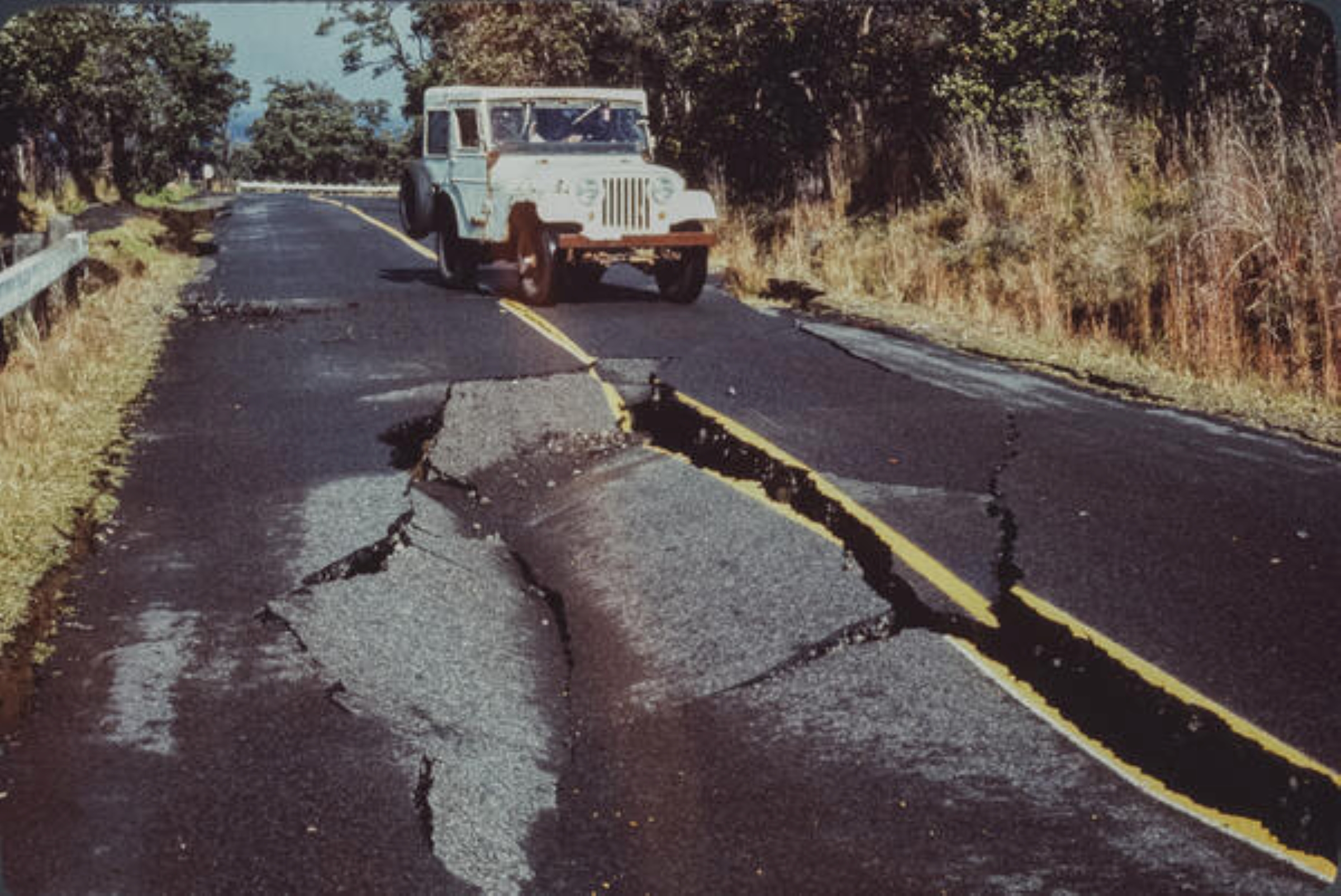
The earthquake caused an estimated $2.7 million in damages, mostly in Hilo, and included cracks in roads, water pipes and walls; toppled chimneys; collapsed water tanks, rock walls and fences; broken windows; and materials on shelves falling and breaking.
More damaging than the earthquake was the fatal tsunami that swept the island’s shores shortly afterward.
Campers at Halapē, on the south coast in Hawaiʻi Volcanoes National Park, were awakened by the shaking and rockfalls from the pali above triggered by it.
As recorded in a U.S. Geological Survey report detailing the survivor accounts, the campers recognized that a tsunami could follow the earthquake. They saw the ocean noticeably rising and quickly fled for higher ground, but the water overtook them.
Most of the campers were swept into a crack, where one described the several tsunami waves as feeling like being inside a washing machine. The water receded about 10 minutes after the earthquake.
One camper was swept out and never found; another drowned or was battered to death by the waves; seven others were hospitalized afterward.
The tsunami wrapped around Hawaiʻi Island, with waves that damaged docks and piers, stranded and sunk boats, demolished homes and businesses in Punaluʻu and flooded Aliʻi Drive in Kona.
Its highest wave reached an estimated 48 feet above the shoreline east of Halapē, leaving a line of vegetation, rocks and other debris.
In total, the tsunami caused an estimated $1.4 million in damages, for a total of $4.1 million in damages from the earthquake and tsunami combined.
Tsunami waves arrived in Hilo just 20 minutes after the earthquake struck. This is much quicker than tsunami generated by distant earthquakes, such as on July 29, when a magnitude-8.8 earthquake struck the Kamchatka Peninsula, Russia.
The Pacific Tsunami Warning Center forecast that tsunami waves from the Kamchatka earthquake would arrive in Hawaiʻi more than 5 hours after the earthquake, giving time for evacuation of coastal zones.
When you feel strong shaking In Hawaiʻi, that is the warning for a potential tsunami. People near the coast should immediately head for higher ground.
If a local tsunami is generated, it will arrive quickly, possibly before any sirens can be sounded or emergency messages can be issued.
Whether or not a local tsunami is generated depends on if there is significant vertical submarine ground movement associated with the earthquake.
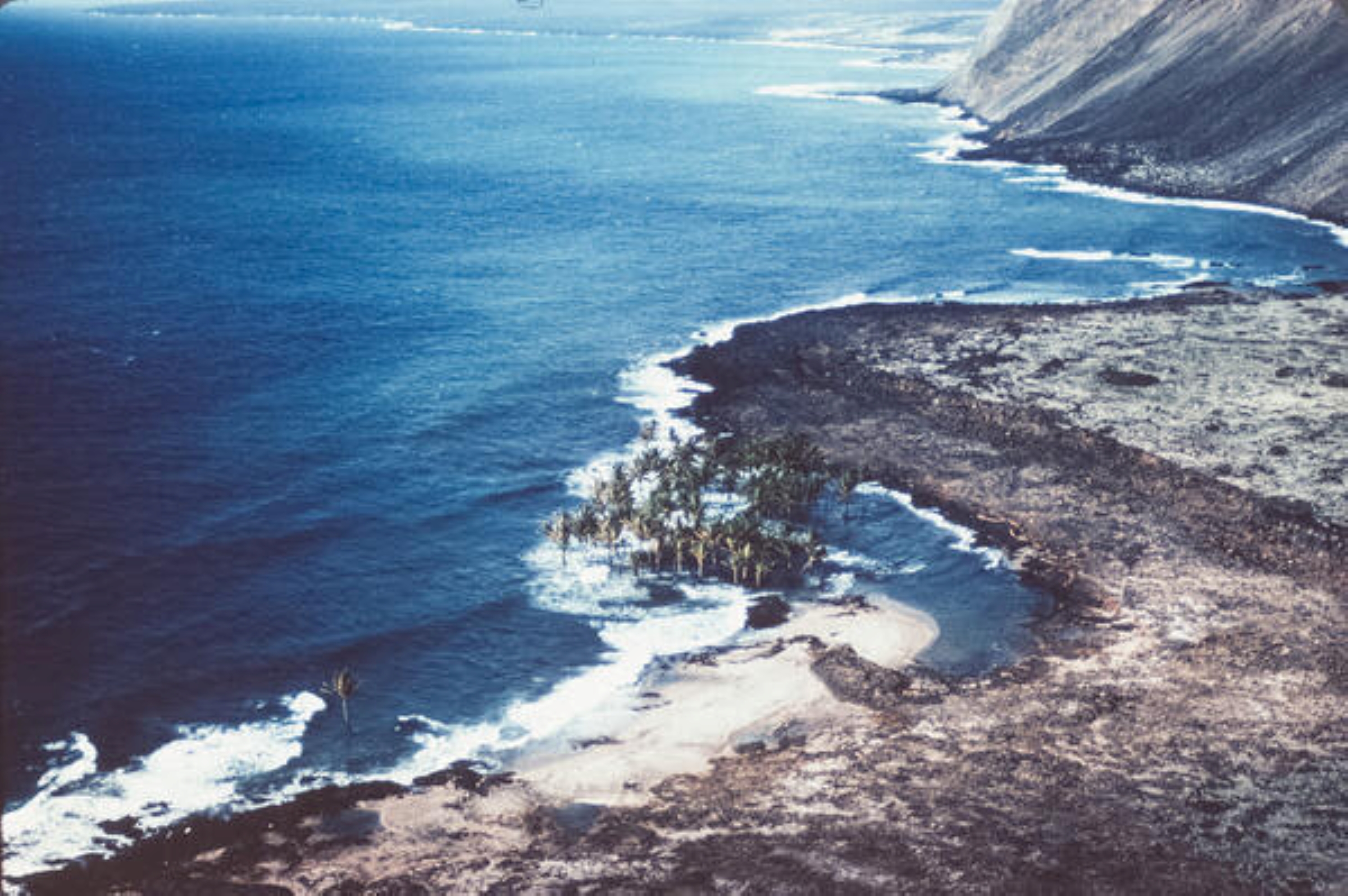
In 1975, areas along the south coast of Hawaiʻi Island, from Honuʻapo to Kaimū, moved as much as 26 feet horizontally and subsided by as much as 11.5 feet, submerging vegetation and inundating the former coastline.
The earthquake also produced extensive cracks on a 15-mile stretch of the Hilina fault system, with up to 5 feet of vertical offset.
Kīlauea was at a high level of inflation in November 1975 and the earthquake also triggered a small volume and brief eruption within Kaluapele, Kīlauea’s summit caldera. The eruption began less than an hour after the earthquake and was done within 24 hours.
While lava flows and fountains often change topography of portions of Hawaiʻi Island, less-frequent large earthquakes and ground movements have the potential to reshape the coastline and cause damage over larger areas.
Click here for more information about earthquake preparedness.
In next week’s “Volcano Watch,” we’ll learn about how our understanding and monitoring of Kīlauea’s south flank — and hazards associated with its movement — have changed since 1975.
The Pacific Tsunami Museum in Hilo will host a series of special events On Nov. 29 to remember the events of that day 50 years ago; learn more here.
VOLCANO ACTIVITY UPDATES
KĪLAUEA
VOLCANO ALERT LEVEL: Watch
Kīlauea has been erupting episodically within the summit caldera since Dec. 23, 2024.
Episode 36 lava fountaining happened for 5 hours Nov. 4. Glow from the vents was observed during the past week through nighttime hours. No unusual activity has been noted along Kīlauea’s East Rift Zone or Southwest Rift Zone.
WHAT’S NEXT? The summit is reinflating; forecasting models indicate Episode 37 is likely to start between Nov. 21 and 26.
MAUNA LOA
VOLCANO ALERT LEVEL: Normal
Mauna Loa is not erupting. Visit the U.S. Geological Survey’s Mauna Loa web page to learn more about what’s happening at Mauna Loa as it continue to show only minor inflation beneath the summit as the volcano recovers from the 2022 eruption and magma replenishes the reservoir system.
Hawaiian Volcano Observatory continues to closely monitor Kīlauea and Mauna Loa.
EARTHQUAKES
No earthquakes were reported felt in the Hawaiian Islands during the past week.
Visit the Hawaiian Volcano Observatory website for past “Volcano Watch” articles, Kīlauea and Mauna Loa updates, volcano photos, maps, recent earthquake information and more. Email questions to askHVO@usgs.gov. Learn even more here.
