

Volcano Watch: Volcano and earthquake monitoring in American Samoa
“Volcano Watch” is a weekly article and activity update written by U.S. Geological Survey Hawaiian Volcano Observatory scientists and affiliates. Today’s article is by Natalia Deligne.
American Samoa is a United States territory comprised of the easternmost islands of a volcanic island chain formed by the Samoan hot spot in the South Pacific Ocean. Its small islands are the tops of volcanoes, and there is an active volcanic seamount nearby.
The most recent eruption witnessed by local residents occurred in 1866, and submarine eruptions and earthquakes remind us that this region remains volcanically active.
American Samoa includes Tutuila Island, the main population center; Aunuʻu Island; and the Manuʻa Islands of Taʻū and Ofu-Olosega, about 70 miles to the east.
Vailuluʻu Seamount is about 30 miles east of the Manuʻa Islands on top of the Samoan hot spot, where submarine eruptions have occurred several times in the past few decades. Additionally, a nearshore eruption occurred in 1866 east of Ofu-Olosega.
Away from the Samoan hot spot, large earthquakes — sometimes greater than magnitude 8 — can happen along the Tonga Trench, located about 150 miles southwest of the Samoan archipelago.
An intense swarm of earthquakes was widely felt in the Manuʻa Islands from July 26 to October 2022, leading to an emergency declaration Aug. 8 by the American Samoa Department of Homeland Security.
The National Weather Service office at Pago Pago and Hawaiian Volcano Observatory deployed staff and resources to the Manuʻa Islands beginning Aug. 13.
Prior to the swarm, American Samoa had no local earthquake monitoring. The closest station was in the Independent State of Samoa, located about 150 miles west of the Manuʻa Islands.
Hawaiian Volcano Observatory and National Weather Service staff rapidly deployed local seismic sensors in the Manuʻa and Tutuila islands, which revealed hundreds of earthquakes per day were occurring about 10 to 15 miles north of Taʻū Island.
The data also showed that along with the intense earthquake activity, molten magma was likely migrating into the area. Fortunately, the number and size of earthquakes declined significantly after August, ending the crisis.
During the 3 years since, Hawaiian Volcano Observatory and U.S. Geological Survey earthquake hazards program continue to actively assess the region for local volcanic and earthquake activity.
All volcanoes in American Samoa are currently at Volcano Alert Level/Aviation Color Code Normal/Green, meaning they are in background/non-eruptive states. Regionally, however, the Tonga Trench continues to produce numerous earthquakes, as is common for subduction zones.
A recent example occurred Aug. 18 this year, when a magnitude-5.5 earthquake was observed and located by U.S. Geological Survey.
In collaboration with National Weather Service, Hawaiian Volcano Observatory staff members went to the Manuʻa Islands for joint outreach with the villages of Olosega, Ofu, Taʻū, Faleasao and Fitiʻuta.
They met with teachers and community leaders to share information about the volcanoes of American Samoa; National Weather Service staff shared information about tsunami, hurricanes and other weather and marine hazards.
Between community meetings, they also helped maintain and improve the monitoring network.
There were two major initiatives.
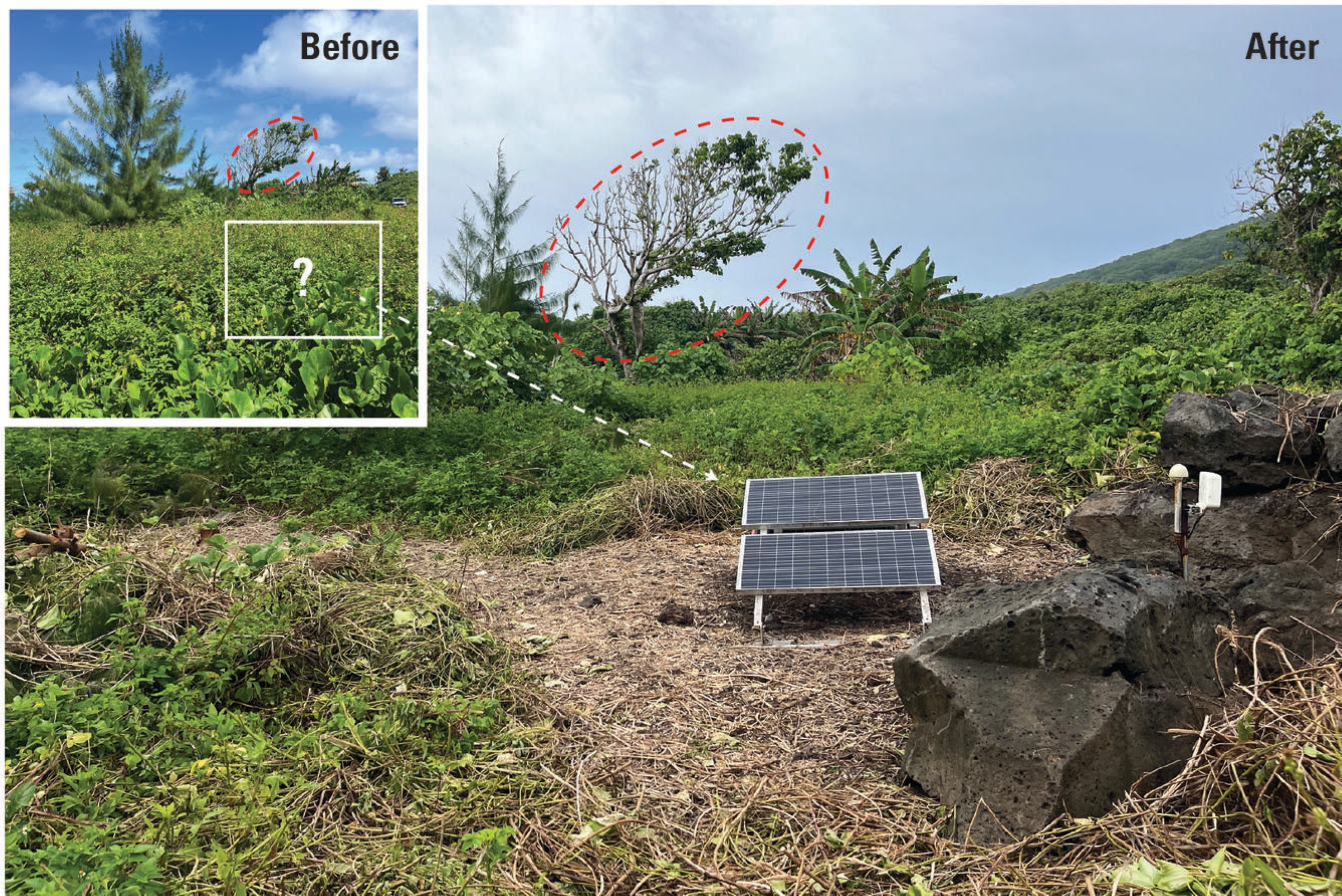
The first was to get a broadband seismic station — the gold standard for earthquake and volcano monitoring — back online in eastern Taʻū.
Unfortunately, during the past year, rapid vegetation growth covered the solar panels used to power the station. As a result, no data was received for several months; thankfully, the network had enough working stations to be able to continue monitoring.
A work party of staff from Hawaiian Volcano Observatory, National Weather Service and American Samoa’s Territorial Emergency Management Coordination Office along with local residents removed vegetation from the site, allowing the station to provide service to the community once again.
The loan of tools was greatly appreciated!
The second initiative was to replace sensors or install other new seismometers, used to supplement the broadband network.
Hawaiian Volcano Observatory thanks the American Samoan Department of Education, Department of Homeland Security, American Samoa Telecommunications Authority and a handful of Manuʻa residents for hosting these seismometers.
After a successful trip to the Manuʻa Islands, Hawaiian Volcano Observatory staff returned to Tutuila for further outreach, including attending the fourth annual Disaster Resilience Summit.
The observatory plans to be back next year for another round of monitoring network maintenance, strengthening partnerships and continuing to serve the people of American Samoa.
To learn more about earthquake and volcano monitoring in American Samoa, visit this U.S. Geological Survey website: Volcanoes in American Samoa.
Volcano Activity Updates
KĪLAUEA volcano, Hawai’i Island
U.S. Geological Survey Volcano Alert Level: Watch
Kīlauea has erupted episodically within its summit caldera since Dec. 23, 2024, with all activity confined to the summit region inside Hawai‘i Volcanoes National Park. Spattering and flames are putting on a show from the north vent. No unusual activity has been noted along Kīlauea’s East Rift Zone or Southwest Rift Zone.
WHAT’S NEXT? Many periods of precursory overflows have happened since shortly after 8:30 a.m. the morning of Sept. 18, marking the start of intermittent precursory eruptive activity of episode 33. No unusual activity has been noted along the volcano’s East Rift Zone or Southwest Rift Zone.
MAUNA LOA volcano, Hawai‘i Island
U.S. Geological Survey Volcano Alert Level: Normal
Mauna Loa is not erupting.
Hawaiian Volcano Observatory continues to closely monitor Kīlauea and Mauna Loa.
EARTHQUAKE report
Two earthquakes were reported felt in the Hawaiian Islands during the past week:
- MAGNITUDE-2.9 located 2 miles southwest of Kahaluʻu-Keauhou at a depth of 2 miles at 9:49 a.m. Sept. 15.
- MAGNITUDE-3.1 located 8 miles southeast of Fern Forest at a depth of 5 miles at 3:01 a.m. Sept. 13.
Visit Hawaiian Volcano Observatory’s website for past “Volcano Watch” articles, Kīlauea and Mauna Loa updates, volcano photos, maps, recent earthquake information and more. Email questions to askHVO@usgs.gov.
Sponsored Content
