

Final Kiko update: Storm continues to weaken as it passes north of Kauaʻi today
Final Update, 5 a.m., Sept. 10: The once powerful category 4 Hurricane Kiko is now a remnant low, with maximum sustained winds of 35 mph.
Swells generated by Kiko are diminishing today, as are the threats of high surf and rip currents.
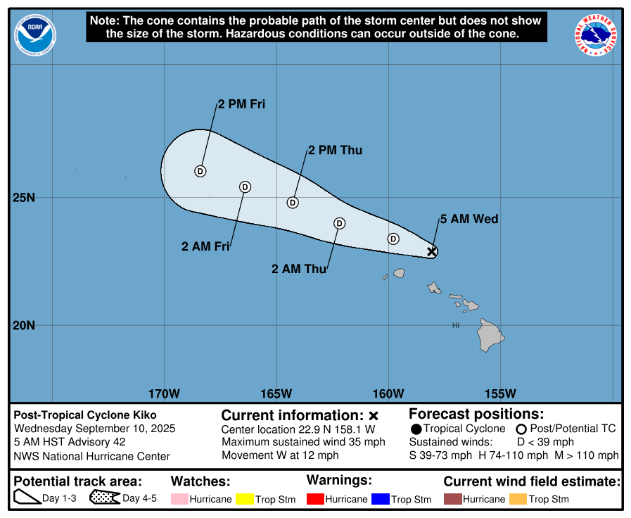
It has already has passed well north of the Big Island and is continuing moving west past the other Hawaiian Islands. As of the 5 a.m. National Hurricane Advisory, the storm was 110 miles north of Honolulu.
The storm is moving northwest at about 12 mph, but is expected to move toward the west-northwest soon. This general motion will continue for the next couple of days.
Update #18, 5 p.m. Sept. 9: Tropical Storm Kiko has passed the Big Island and now is 150 miles from Honolulu, although it is still producing life-threatening rip currents and high surf across the Hawaiian Islands.
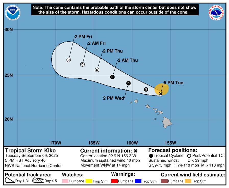
Swells generated by Kiko are building from east to west across the exposed Hawaiian waters and are forecast to peak tonight through Wednesday. Weakening is expected, and the system is forecast to become post-tropical in a couple days, according to the National Hurricane Center.
Maximum sustained winds are near 40 miles per hour with higher gusts, and tropical-storm-force winds extend outward up to 90 miles.
Swells from Kiko continues to fill in across Kauaʻi this afternoon and will likely peak this evening and tonight. Meanwhile, surf is on a steady decline over the Big Island and will likely begin its steady decline over Maui and Molokai this evening.
A high surf warning has been cancelled for the Big Island’s north- and east-facing shores. .
Update #17, 11 a.m. Sept. 9: Kiko is producing life-threatening rip currents and high surf across portions of the Hawaiian Islands.
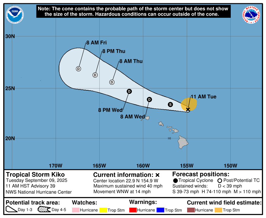
According to an 11 a.m. update from the National Hurricane Center, swells generated by the tropical storm are building from east to west across the exposed Hawaiian waters and are forecast to peak today through Wednesday.
A high surf warning remains in effect for east-facing shores till 6 p.m. According to the National Weather Service, large breaking waves of 10 to 15 feet are expected.
Kiko, now 220 miles north of Hilo, is forecast to pass north of the Hawaiian Islands today
and Wednesday. Additional weakening is expected, and the threat of direct impacts on the islands continues to diminish, though interests should still monitor Kiko’s progress and the latest forecasts.

The storm is moving toward the west-northwest near 14 mph and this motion is expected to continue for the next few days, while passing north of the main Hawaiian Islands.
Maximum sustained winds have decreased to near 40 mph with higher gusts. Additional weakening is expected, and the system may become post-tropical in a couple of days.
Tropical-storm-force winds extend outward up to 90 miles from the center.
Update #16, 5 a.m., Sept. 9: Kiko, which substantially weakened overnight to a tropical storm, will pass north of the Big Island later today.
The storm was 210 miles east of Hilo and 300 miles east of Honolulu as of the 5 a.m. advisory by the National Hurricane Center.
Maximum sustained winds have decreased to about 45 mph with higher gusts. These winds can be felt up to 105 miles from the storm’s center.
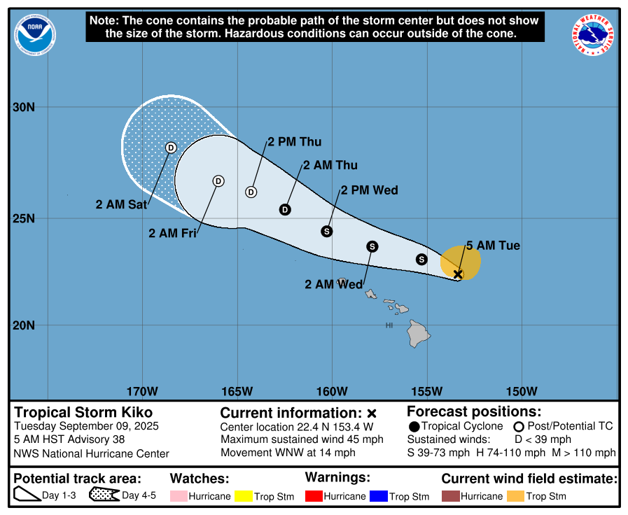
Kiko is moving toward the west-northwest near 14 mph. This track is expected to continue for the next few days, while passing north of the main Hawaiian Islands. Additional weakening is expected, and the system may become post-tropical in a few days, according to the National Hurricane Center
There remain no coastal watches or warnings in effect. But be wary of swells generated by Kiko, which are building from east to west across the exposed Hawaiian waters. They are forecast to peak today through Wednesday, potentially producing life-threatening surf and
rip currents.
Update #15, 5 p.m., Sept. 8: Hurricane Kiko is still a category 1 storm, but is expected to continue to weaken to a tropical storm late tonight.
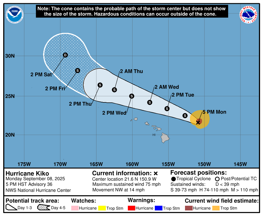
According to the National Hurricane Center, Kiko is moving toward the northwest near 14 mph and this motion is expected to continue for the next few days. On the forecast track, Kiko is expected to pass north of the main Hawaiian Islands on Tuesday and Wednesday.
There are no coastal watches or warnings in effect. However, the Hawaiʻi County Civil Defense Agency has issued a high surf warning all north- and east-facing shores on Hawaiʻi Island.
Swells generated by Kiko are gradually building from east to west across the exposed Hawaiian waters and are forecast to peak tonight through Wednesday, potentially producing life-threatening surf and rip currents
As of 5 p.m. on Monday, Kiko was about 300 miles east of Hilo and 450 miles east of Honolulu, with maximum sustained winds of 75 mph. Hurricane-force winds extend outward up to 45 miles from the center and tropical-storm-force winds extend outward up to 125 miles.
Update #14, 5 a.m. Sept.8: Kiko, now a category 1 hurricane, is expected to continue to weaken to a tropical storm later today and stay a tropical storm as it passes north of the Big Island tomorrow, according to the National Hurricane Center.
There are no coastal watches or warnings in effect. But the swells generated by Kiko are forecast to gradually build and peak along east-facing exposures of the Hawaiian Islands later today through midweek, potentially producing life-threatening surf and rip currents.
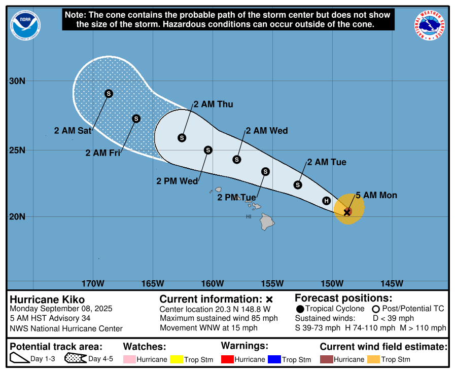
As of 5 a.m. on Monday, Kiko was about 410 miles east of Hilo and 590 miles east of Honolulu, with maximum sustained winds of 85 mph. Hurricane-force winds extend outward up to 35 miles from the center and tropical-storm-force winds extend outward up to 115 miles.
Kiko is moving west-northwest at nearly 15 mph. This track is expected to continue for the next few days, with the storm passing north of the main Hawaiian Islands on Tuesday through Wednesday.
Update #13, 5 p.m. Sept.7: Kiko remains a category 2 Hurricane.
As of 5 p.m., Kiko is 555 miles east of Hilo and 750 miles east of Honolulu with sustained winds of 105 miles per hour with higher gusts.
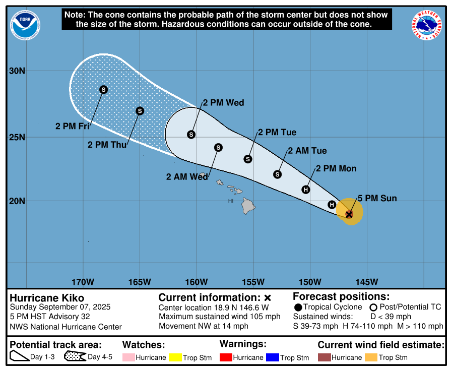
Further weakening is expected over the next few days. Kiko is forecast to become a tropical storm late Monday night.
The swells caused by Hurricane Kiko are expected to gradually increase and are forecast to reach their peak along east-facing shores of the Hawaiian Islands late Monday through midweek, potentially causing dangerous surf and rip currents.
There are no coastal watches or warnings in effect.
Update #12, 12 p.m. Sept. 7: The Air Force Reserve Hurricane Hunter Aircraft reports that Hurricane Kiko’s maximum sustained winds have decreased to near 110 miles per hour.
Additional weakening is forecast during the next few days, with Kiko expected to become a tropical storm by late Monday, according to the National Hurricane Center.
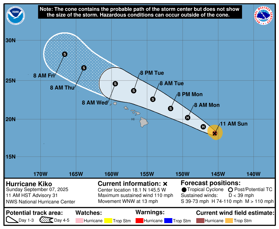
The hurricane, which was 635 miles east of Hilo as of 11 a.m. on Sunday, is expected to pass north of the Big Island on Tuesday, and the other Hawaiian Islands by Wednesday.
But swells generated by Kiko are expected to begin reaching the Big Island and Maui today. The swell is expected to gradually build and peak along east-facing shores Monday through midweek, potentially producing life-threatening surf and rip currents.
Kiko is moving west-northwest at nearly 13 mph, and is expected to keep this general direction through Wednesday with a slight increase in forward speed.
Hurricane-force winds extend outward up to 35 miles from the center and tropical-storm-force winds extend outward up to 80 miles.
There are no coastal watches or warnings in effect.
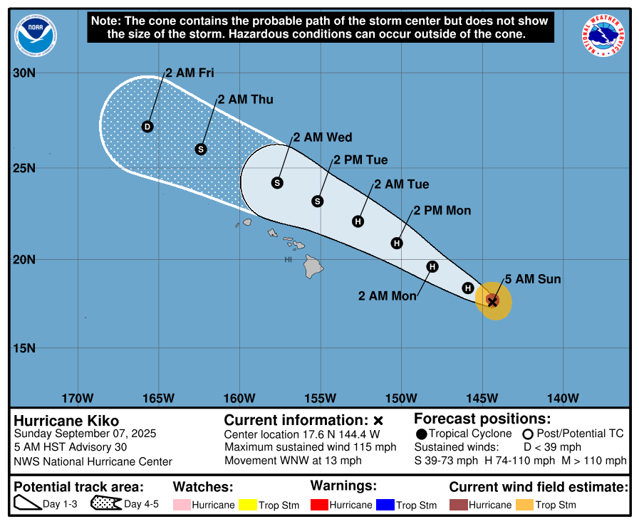
Update #11, 5 a.m. Sept. 7: Hurricane Kiko, now a category 3 hurricane with maximum sustained winds of 115 mph and higher gusts, is about 715 miles east of Hilo as of 5 a.m. on Sunday.
The hurricane, which gradually weakened over cooler waters, is forecast to pass north of the Big Island on Tuesday and the rest of the Hawaiian Islands on Tuesday and Wednesday, according to the National Hurricane Center.
Swells generated by Kiko are expected to begin reaching the Big Island and Maui later today, and gradually build.
The swells are forecast to peak along east-facing shores of the Hawaiian Islands late Monday through midweek, potentially producing life-threatening surf and rip currents.
Kiko is moving west-northwest at nearly 13 mph, and is expected to keep this general direction through Wednesday.
Hurricane-force winds extend outward up to 35 miles from the center and tropical-storm-force winds extend outward up to 80 miles.
There are no coastal watches or warnings in effect.
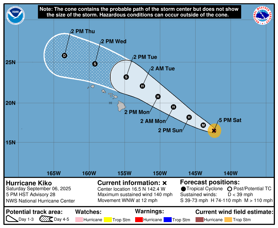
Update #10, 5 p.m. Sept. 6: Kiko has once again re-strengthen to a category 4 hurricane.
At 5 p.m., the National Hurricane Center reported the hurricane being 860 miles east-southeast of Hilo and about 1,065 miles east-southeast of Honolulu, with maximum sustained winds of 140 mph.
Only minor fluctuations in strength are anticipated tonight, with gradual weakening expected to begin by Sunday.
There are no coastal watches or warnings in effect. Kiko is moving toward the west-northwest near 12 mph and this general motion is expected to continue for the next few days, the latest advisory reports.
Hurricane-force winds extend outward up to 25 miles from the center and tropical-storm-force winds extend outward up to 70 miles.
Swells generated by Hurricane Kiko are expected to reach the Big Island and Maui by Sunday. These swells will gradually build and are forecast to peak along east-facing exposures of the Hawaiian Islands late Monday through midweek, potentially producing life-threatening surf and rip currents.
While the forecast track currently calls for Kiko to pass north of the islands, it is still too soon to determine the exact location or magnitude of potential impacts from the cyclone’s winds or rains.
Update #9, 11 a.m. Sept. 6: Kiko is weakening as the hurricane moves west-northwest through the central Pacific.
As of 11 a.m. Saturday, the hurricane was 935 miles east-southeast of Hilo and about 1,135 miles east-southeast of Honolulu, with maximum sustained winds of 120 mph, according to a public advisory from the National Hurricane Center.
Click here for previous hurricane updates.
Kiko, now a category 3 hurricane, is moving toward the west-northwest near 12 mph and this general motion is expected to continue for the next few days. Gradual weakening is also expected, according to the advisory.
An Air Force Hurricane Hunter aircraft is scheduled to investigate Kiko later today to provide a better look at Kiko’s intensity and structure.
Kiko is forecast to approach the Hawaiian Islands during the early to middle portion of next week. While the forecast track currently calls for Kiko to pass north of the islands, it is still too soon to determine the exact location or magnitude of potential impacts from the cyclone’s winds or rains.
Swells generated by Hurricane Kiko are expected to reach the Big Island and Maui by Sunday. These swells will gradually build and are forecast to peak along east-facing exposures of the Hawaiian Islands late Monday through midweek, potentially producing life-threatening surf and rip currents.
Hurricane-force winds extend outward up to 25 miles from the center and tropical-storm-force winds extend outward up to 80 miles.
Sponsored Content
