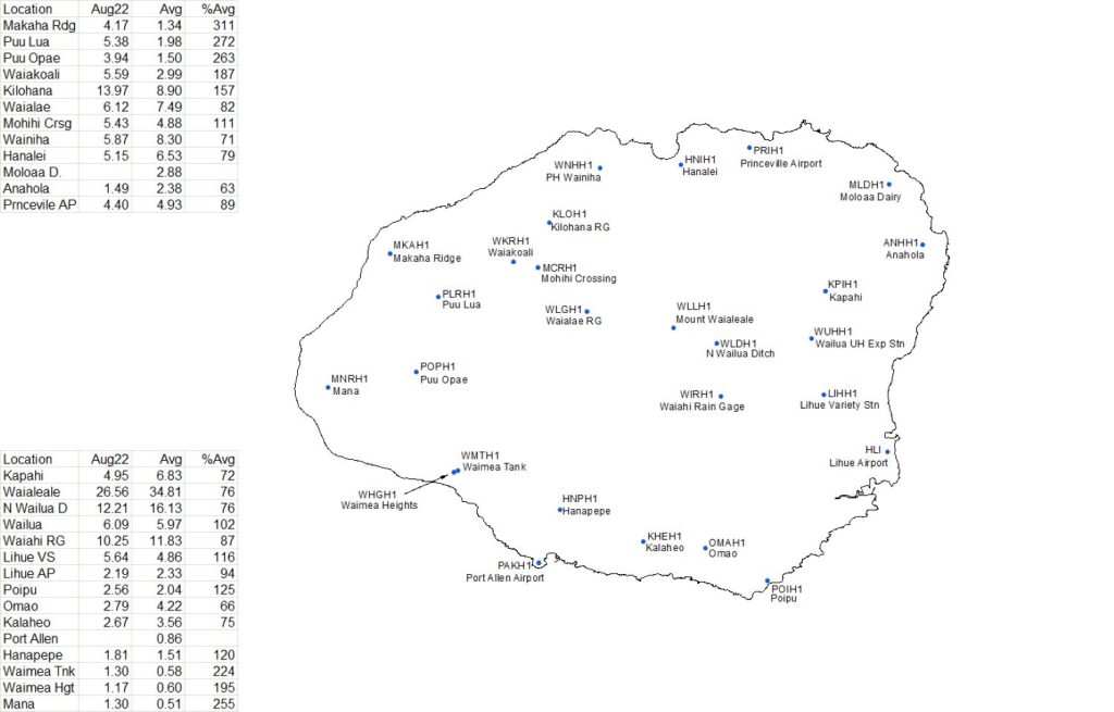
Thank goodness for a break in trade winds during the last week of August. That break allowed a weak low-level trough to bring rainfall to the island, helping push most rainfall totals for the month to near or above average.
The U.S. Geological Survey’s rain gauge on Mount Waiʻaleʻale had the highest monthly total for last month with 26.56 inches, or 76% of average, according to the monthly precipitation summary for August prepared by Kevin Kodama, senior service hydrologist with the National Weather Service in Honolulu. However, the highest daily total of 3.87 inches came Aug. 4 at the USGS Kilohana rain gauge as the first of three weak low pressure troughs passed north of the state.

But while several sites on Kauaʻi had higher than average rainfall, the Anahola rain gauge in northeast Kauaʻi posted its lowest August total since 2012.
“Despite the boost in rainfall for many locations, rainfall totals for 2022 through the end of August remained below average at most of the gauges on Kauaʻi,” Kodama’s report said. “Many of these totals were 40%-70% of average.”
The Mount Waiʻaleʻale gauge saw the highest year-to-date total of 194.58 inches, or 74% of average.
For a map of year-to-date rainfall totals on the island, click here.
Trade winds were present throughout the main Hawaiian Islands during most of August, but were weaker and less consistent than in June and July, Kodama’s report said. There were three breaks in the trades, all of which produced short periods of heavy rainfall for some parts of the state.
The first break was Aug. 3-5, which saw a weak low pressure trough pass westward just north of the state. That allowed land and sea breezes to dominate conditions. Parts of Maui and Oʻahu saw brief but heavy afternoon showers, with some spots on Oʻahu seeing some minor flooding but no significant damage.
The second break in trades from Aug. 15-17 was caused by another weak low-level trough. The windward slopes of the Koʻolau Range on Oʻahu, from Kāneʻohe to Kahuku, seeing the most significant rainfall during the break.
During the third break, from Aug. 22-25, Peak 24-hour rainfall totals were in the range of 1-2 inches over the windward side of the Kohala Mountains on the Big Island, portions of windward and west Kauaʻi and along the windward slopes of Oʻahu, Molokaʻi and Maui.
August also is normally the peak month for tropical cyclone activity in the central North Pacific basin, but there were no tropical cyclones the entire month. A weak tropical disturbance passed to the south of the state Aug. 10-11, but only caused an increase in trade winds and no significant spike in rainfall.
Kodama reported that while some parts of the islands received much needed rainfall during August, areas hardest hit by drought, including central Maui and west Molokaʻi, did not have enough rain to improve conditions. For additional drought details, refer to the Drought Information Statement online.


