


Tropical Storm Nolo was about 345 miles west of Līhuʻe as of the 2 a.m. Wednesday advisory from the National Hurricane Center. But the outer bands east of Nolo’s track will produce 3 to 6 inches of rain across Kauaʻi and Niʻihau through Thursday.
This rainfall could produce areas of flooding and mudslides, especially in areas of steep terrain, the advisory said..
Nolo has maximum sustained winds of 65 mph and was moving west at 6 mph. The storm has tracked farther west than expected and is weakening, but its wind field is expanding on the eastern side, toward the islands.
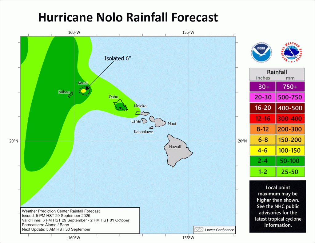
While wind no longer is a factor, the storm still is bringing rain and high surf to Kauaʻi and Niʻihau.
Swells generated by Nolo will affect south- and west-facing shores of the main Hawaiian Islands for the next few days. These swells are likely to cause life-threatening surf and rip current conditions.
Hurricane Nolo updates are available at the National Hurricane Center and Central Pacific Hurricane Center website.
Emergency preparedness
Kauaʻi Emergency Management Agency encourages every household, business and visitor to build or refresh an emergency kit, review family plans know evacuation routes now.
Preparation is the single most important step in keeping yourself, loved ones and neighbors safe.
Disaster kits should include:
- At least 14 days of non-perishable food.
- 1 gallon of water per person per day.
- Battery-powered radio.
- Flashlight with extra batteries.
- Extra supply of prescription medicines.
- Important documents in a waterproof container.
- Cash in small bills.
- Other items specific to individual needs, including those of keiki, kūpuna, pets and family members with access and functional needs.
Wildfire prevention
Ongoing hurricane cleanup increases wildfire risk. Residents and businesses are encouraged to:
- Avoid activities that could cause sparks, such as landscaping during hot, dry, windy afternoons.
- Keep a water source nearby in case a spark occurs.
- Do not burn green waste or storm debris.
- Before leaving a work area, check for smoldering material.
More storm forecast Information
For more scientific information about the storm forecast, click here.
Monitor products issued by the National Weather Service Honolulu forecast office for storm-specific information about your area, including possible inland watches and warnings.

