


Updated at 7:56 a.m. on Friday.
Strengthening to a Category 1 hurricane on Thursday, Nolo is now churning about 210 miles south of South Point on Hawai‘i Island.
Kaua‘i is expected to stay out of the path of Nolo as it is on track to pass well south of the Garden Isle.
Currently, the maximum sustained winds of the storm have increased to 85 mph, according to the Central Pacific Hurricane Center’s 5 a.m. Friday advisory. Nolo is expected to remain south of the Big Island through Saturday before turning westward and moving away from the island.
Tropical storm conditions are expected to begin on the Big Island tonight with hurricane conditions possible on Saturday, particularly in areas of steep terrain.
Big Island residents are being urged to finish preparing for the storm soon. Nolo is forecast to become a hurricane by Thursday night and could become a major hurricane by the weekend as it approaches the Big Island.
A hurricane watch and tropical storm warning are currently in effect for the Big Island.
Life-threatening, catastrophic flooding and mudslides are possible, especially in areas of steep terrain across the Big Island and Maui. Across the remainder of Hawai‘i, lesser rainfall totals are expected, with isolated flooding possible.
Large and damaging waves also are possible along portions of the Big Island’s coastline into the weekend.
Tropical storm-force winds extended outward up to 115 miles from the storm’s center as of Wednesday night.
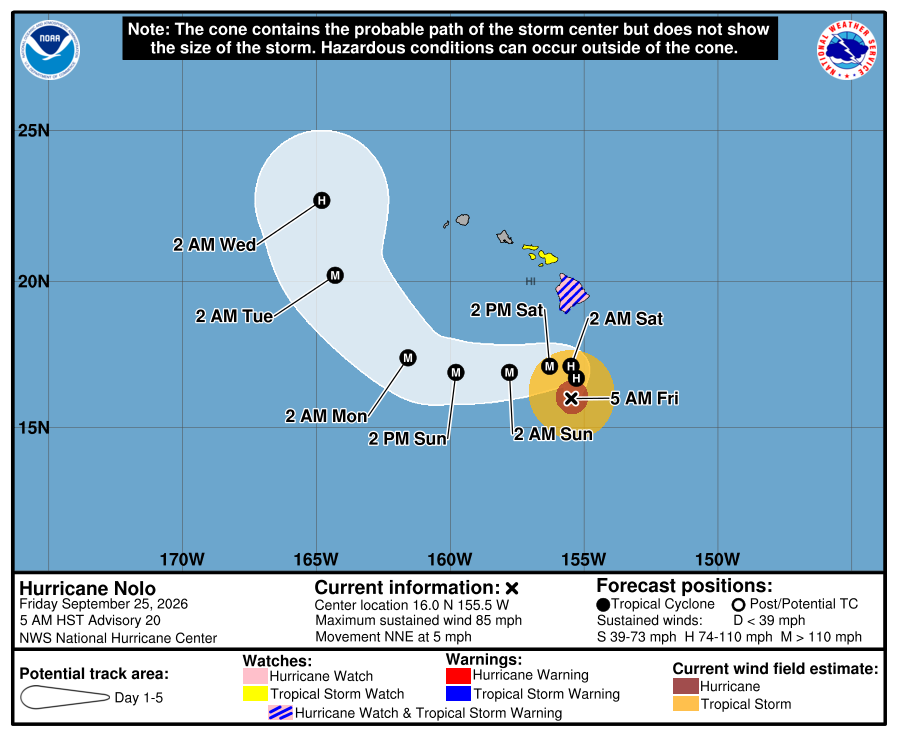
A track closer to the Big Island could also result in interactions with the island’s terrain that could further influence the cyclone’s subsequent motion.
“Given these uncertainties, confidence in the track forecast remains lower than normal,” the forecast said.
Hazards likely to impact land
WIND: Hurricane conditions are possible in the watch area starting as early as Friday night.
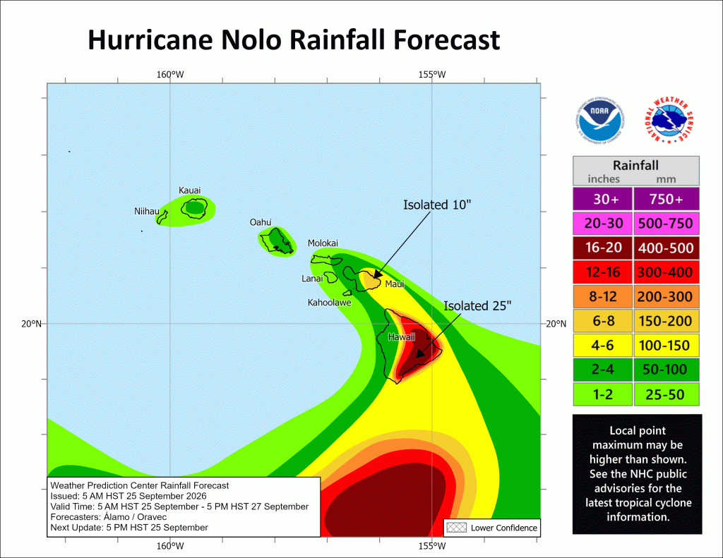
RAINFALL: For the eastern and southern portions of the Big Island, Nolo will produce rainfall totals of 10 to 15 inches with maximum amounts of 25 inches. This rainfall could produce catastrophic, life-threatening flooding and mudslides, especially in areas of steep terrain.
For the western portions of the Big Island, rainfall totals of 2 to 4 inches with maximum amounts of 8 inches are expected. For Maui, rainfall totals of 4 to 6 inches with maximum amounts of 10 inches are expected. Life-threatening flooding and mudslides are possible, especially in areas of high terrain.
Across the remainder of the Hawaiian Islands, rainfall totals of 1 to 3 inches with isolated maximum amounts of 6 inches are expected with isolated flooding possible.
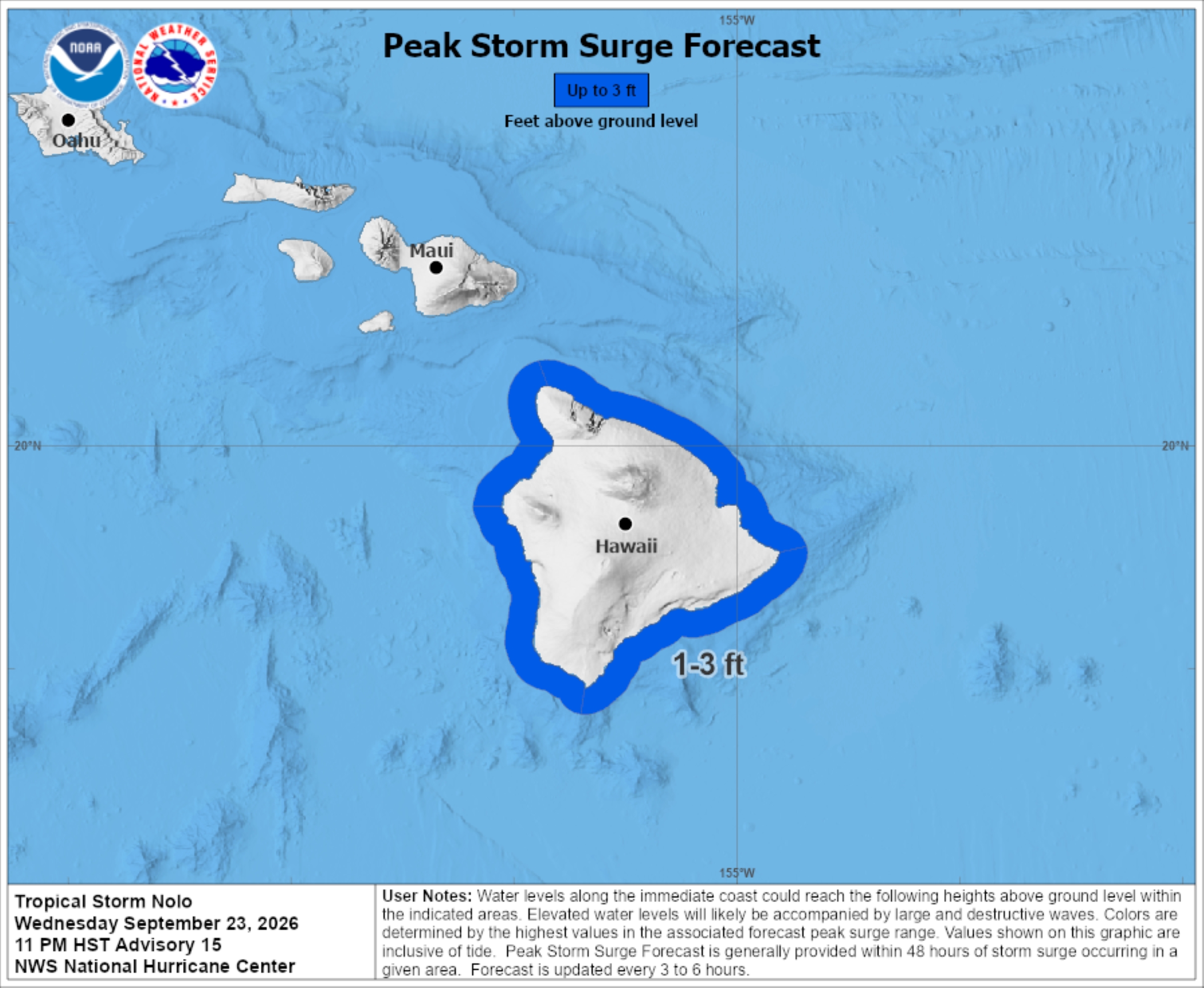
STORM SURGE: The combination of dangerous storm surge and tide will cause normally dry areas near the coast to be flooded by rising waters moving inland from the shoreline. The water could reach 1 to 3 feet above ground in some locations if peak surge occurs at the time of high tide.
The deepest water will occur along the immediate coast near and to the right of the landfall location, where the surge will be accompanied by large and dangerous waves. Surge-related flooding depends on the relative timing of the surge and the tidal cycle, and can vary greatly over short distances.
SURF: Swells generated by Nolo are expected to reach exposed east- and south-facing shores as well as southeast-facing shores of the Big Island by Friday, spreading westward and building through the weekend. These swells are likely to cause life-threatening surf and rip current conditions.
TORNADOES/WATER SPOUTS: Tornadoes and large waterspouts will be possible associated with Nolo, mainly over and near the Big Island, along and to the right of the track of the hurricane.
Additional sources of information
Disaster preparedness information: American Red Cross.
Appropriate preparations: Ready.gov.
For storm information specific to your area, including possible inland watches and warnings, monitor products issued by the National Weather Service Honolulu forecast office.
Kaua‘i Island Utility Cooperative is closely monitoring the depression which could bring weather impacts, such as high winds, to Kaua‘i as early as this weekend.
Members are encouraged to review their personal emergency preparedness plans and make sure they are ready for the possibility of prolonged power outages.
Preparedness tips include:
- Ensure that KIUC has your current contact information (phone, text and email) by calling us at 808.246.4300.
- Make an emergency plan: where to go, what to do and how to meet up if you are separated from your family.
- Know evacuation routes and refuge areas.
- Tie down or put away loose outdoor items to prevent them from becoming flying debris and causing damage.
- Know where your electrical and gas shutoffs are located.
Be prepared for prolonged power interruptions:
- Unplug electrical appliances and sensitive electrical equipment.
- Keep refrigerator and freezer doors closed as long as possible. Food may stay frozen in the refrigerator’s freezer compartment for 12 to 48 hours, and up to 72 hours in a fully loaded separate freezer
- Ensure you have an adequate supply of non-perishable food and water available.
- If you are dependent on electricity for medical reasons, consider backup power options provided by KIUC.
Additional preparedness information can be found on the Kaua‘i Emergency Management Agency website, as well as KIUC’s website.

