Updated at 11:42 p.m. Sept. 4
Hurricane Lowell seems to be going through somewhat of a personality crisis, it seems, as the storm is now a powerful Category 4 hurricane, weakening slightly from its Category 5 status Friday afternoon.
The storm as of the Central Pacific Hurricane Center 11 p.m. advisory update had sustained winds of 155 mph, continuing a westward motion now slightly faster at 11 mph. It was located about 625 miles south-southwest of Līhuʻe.
Lowell is still expected to continue in the same general motion, with a gradual decrease in forward speeed, during the next day or so before turning sharply to the north or north-northeast Sunday.
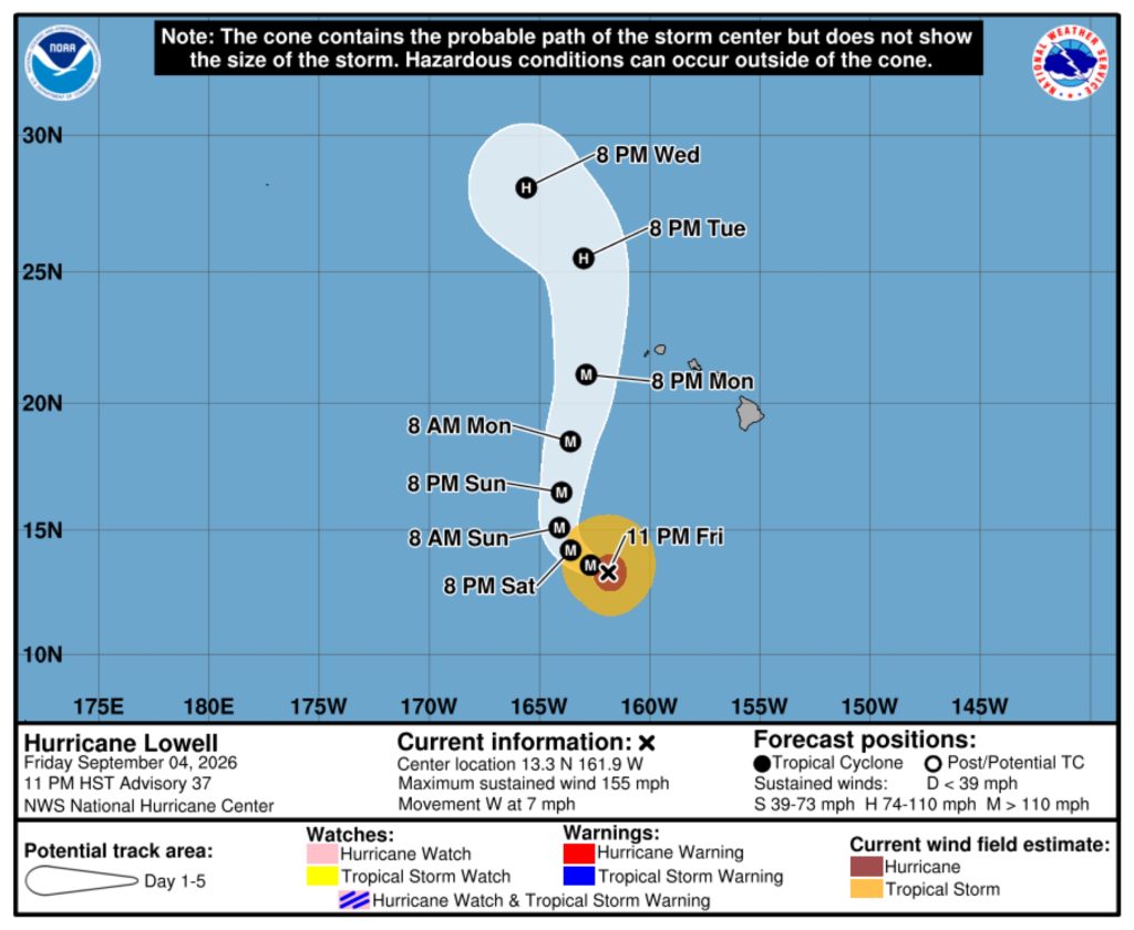
The center of the storm, based on National Hurricane Center graphics, is still expected to pass west of Kauaʻi County as a major hurricane sometime after 8 p.m. Monday and then move north of the state before taking a turn back to the north-northwest by 8 p.m. Tuesday.
Some fluctuations in strength are possible during the next day or so, followed by a gradual weakening trend by early next week.
Hurricane force winds extend outward up to 60 miles and tropical storm force winds extend 160 miles outward from Lowell’s center.
There are no coastal watches or warnings in effect.
However, there remains a high surf advisory in effect until 6 p.m. Saturday for south and east shorelines throughout the entire state as southerly swells from Lowell will keep surf elevated above high surf advisory conditions.
A large, medium-period east swell is filling in from Hurricane Karina to the east of the state producing advisory level surf along east-facing shores while Lowell continues to move water up from the south to impact south-facing shores.
Surf will build to 12 feet along south shorelines and up to 14 feet along eastern exposures, producing large breaking waves and strong currents, both of which could be life-threatening.
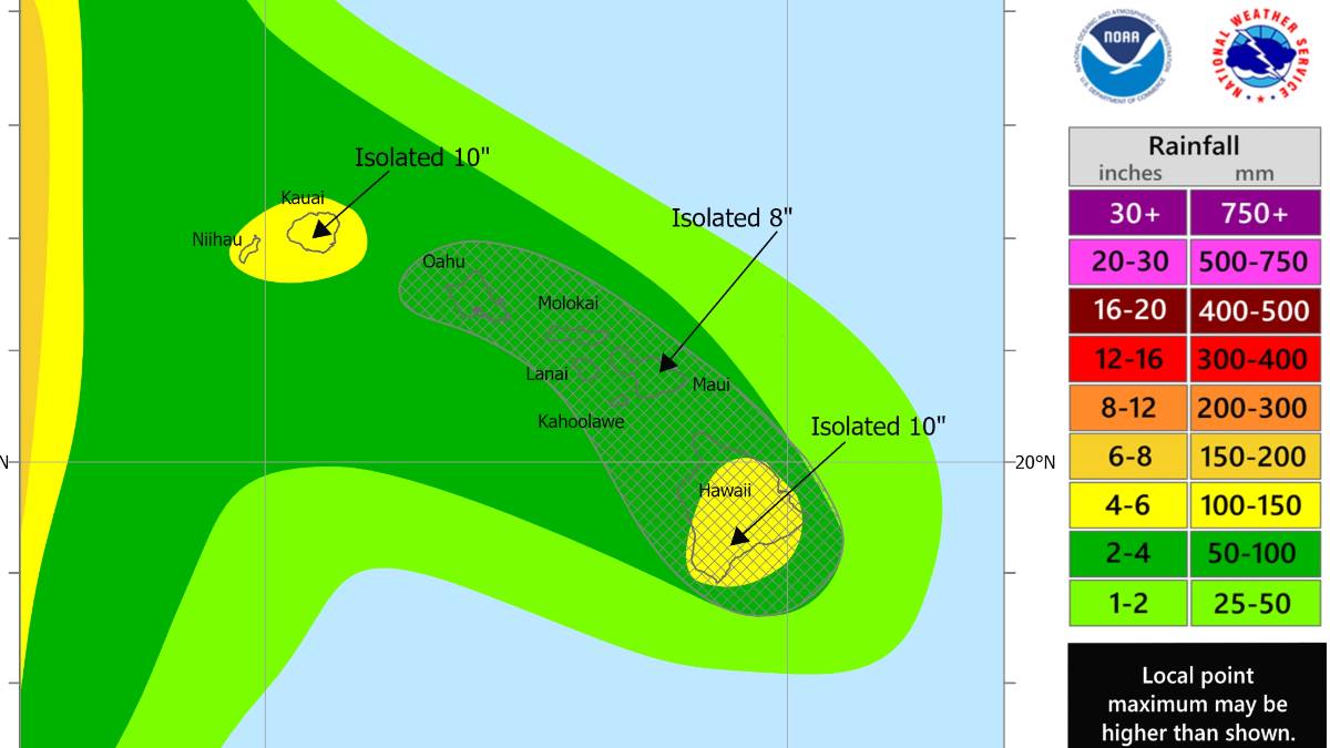
Heavy rain also remains a concern, with estimated rainfall totals from Lowell of 3 to 6 inches, with isolated maximum totals exceeding 10 inches, forecast for Kauaʻi County and the Big Island.
The rainfall could cause flash flooding and mudslides, especially in locations of steep terrain.
Maui is forecast to receive 2 to 4 inches of rain, with isolated maximum totals of up to 8 inches possible. Remaining islands of the state will likely see 1 to 2 inches, with up to 4 inches possible.
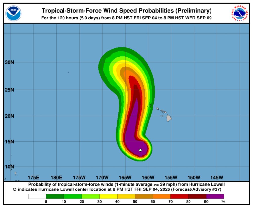
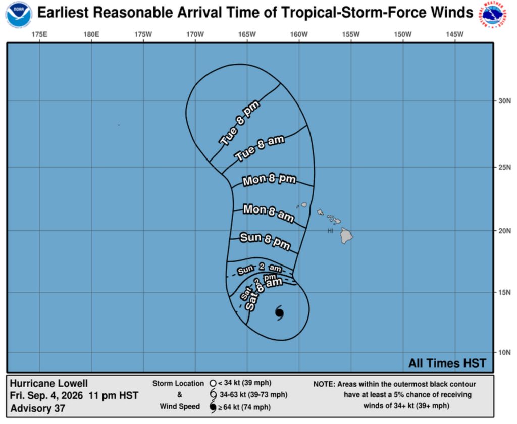
Winds could be an issue, with National Hurricane Center graphics showing Kaua’i County having a 5% to 40% chance of experienceing tropical storm force winds as Lowell moves by to the west.
Those winds are forecast to arrive sometime after 8 a.m. Monday.
The storm is bringing back memories for some Kauaʻi residents of the catastrophic Category 4 Hurricane ʻIniki, which in 1992 struck the island, killing seven people and doing an estimated $3 billion in damage.
“We need everyone on Kauaʻi to take this storm seriously and finish preparing now,” said Kauaʻi County Mayor Derek Kawakami. “Know where you will go if you need to leave your home, gather essential supplies and sign up for emergency alerts. Our county teams are ready, but preparedness begins with each household.”
Residents and visitors should monitor official forecasts, prepare emergency supplies, charge electronic devices, secure outdoor objects and avoid unnecessary travel as conditions worsen. Never drive, walk or swim through floodwaters.
Visitors should confirm flights, accommodations and activities directly with airlines, hotels and other providers. Visitor information is available online and by calling 1-800-GOHAWAII.
To receive county emergency alerts:
- Kauaʻi: Text KAUAIEMA to 888777
- Hawaiʻi Island: Text HAWAIIALERTS to 888777
- Maui County: Text MAUIALERTS to 38276
- Oʻahu: Text HNLALERT to 888777
The public should continue closely monitoring Lowell’s progress. Check National Weather Service forecasts and products for any additional advisories, watches or warnings issued and for specific weather information for your community.