


This story was updated on Sept. 3 at 11:55 p.m.
The center of Hurricane Lowell was located about 595 miles south of Līhuʻe as of the 11 p.m. advisory update from the Central Pacific Hurricane Center, still moving west at 9 mph and with sustained winds of 125 mph, making it now a Category 3 hurricane.
“This general motion, with a gradual decrease in forward speed, is expected during the next day or two, followed by a turn toward the northwest and north this weekend,” said the update.
Some fluctuations in intensity are expected during the next few days; however, Lowell is expected to remain at or near major hurricane status by late Monday and Monday night when it is expected to make its closest approach to Kaua‘i County.
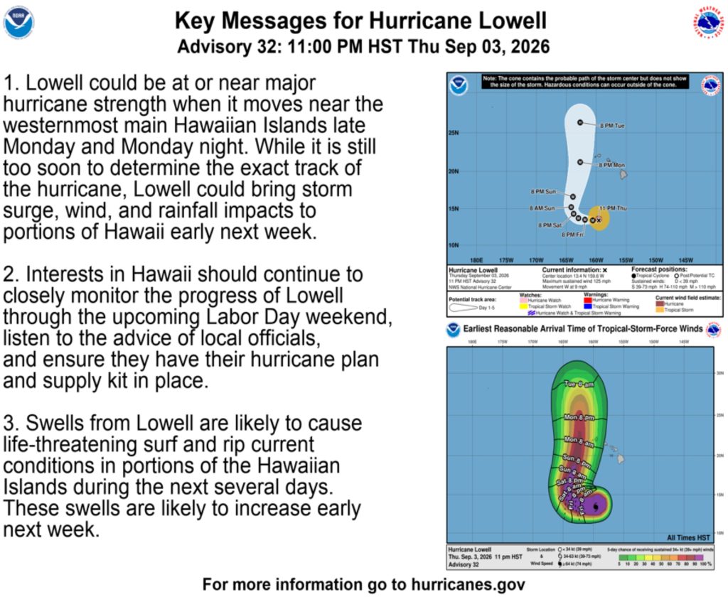
While it is still too soon to determine Lowell’s exact track, the hurricane could bring storm surge, wind and rainfall impacts to portions of Hawai‘i early next week, especially Kaua‘i County.
The new National Hurricane Center track forecast shows Lowell nudged westward in line with the latest consensus, but it should be noted that long-range track details are still of lower confidence.
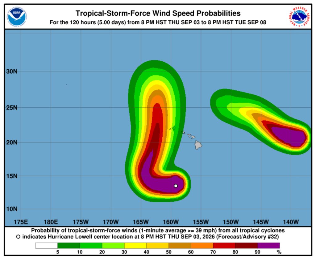
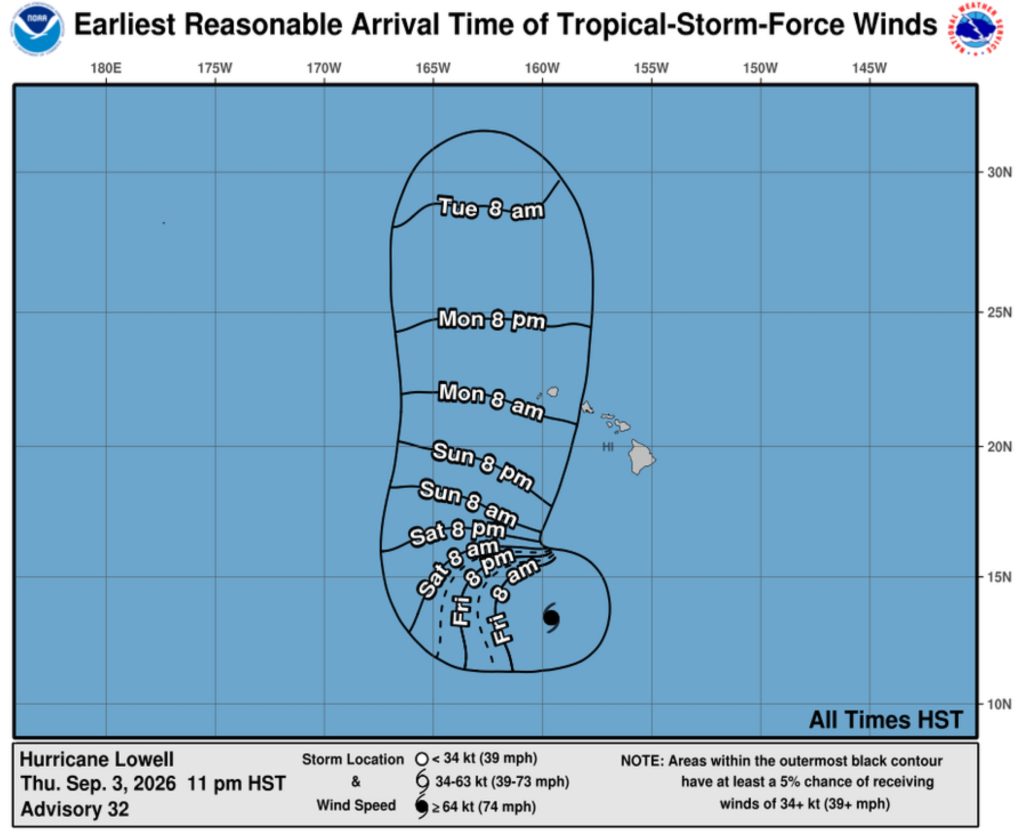
National Hurricane Center/Central Pacific Hurricane Center graphics show Lowell now moving slightly farther to the west of Kaua‘i County than the 5 p.m. Thursday update, with a 20% to 40% chance of tropical storm force winds.
Winds are still expected to arrive by about 8 a.m. or shortly after Monday.
Hurricane force winds on Thursday night extended outward up to 45 miles and tropical storm force winds extended outward up to 140 miles from the hurricane’s center.
Swells generated by Lowell are likely to cause life-threatening surf and rip current conditions in parts of the state during the next several days and forecast to likely increase early next week.
A high surf advisory remains in effect through 6 p.m. today for south and southeast exposures of all islands.
“Swells from Hurricane Lowell [have] filled in and will remain elevated above high surf advisory conditions through Friday,” said National Weather Service forecasters in Honolulu in an advisory update Thursday. “The swell will gradually veer from southeast toward the southwest early next week.”
There are no coastal watches or warnings in effect at this time.
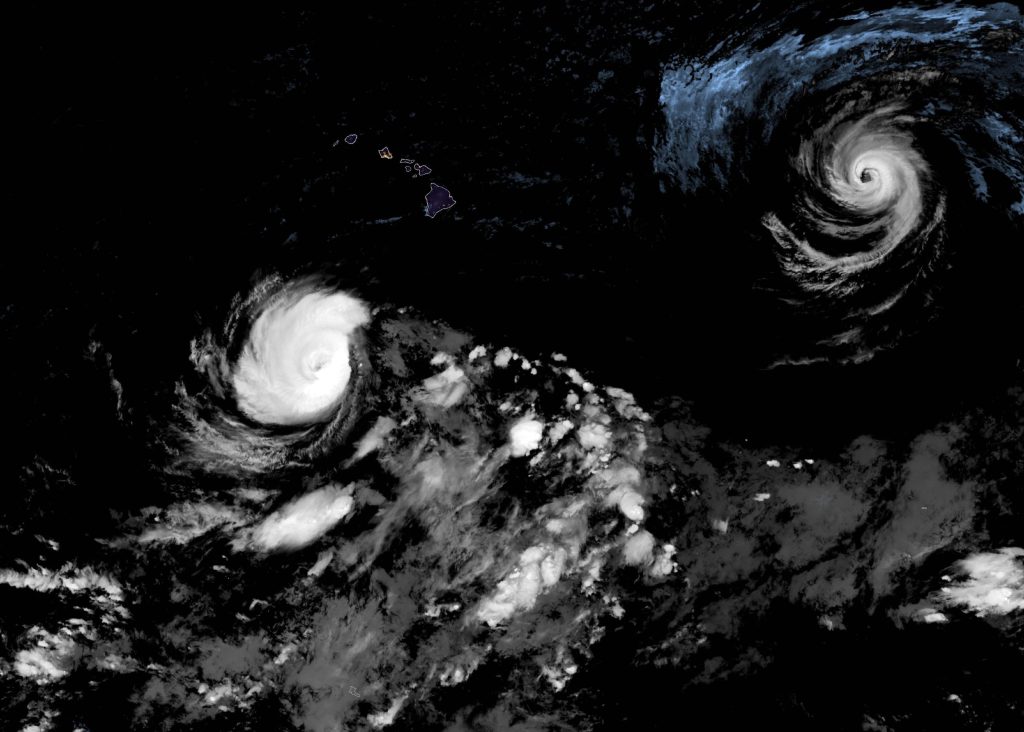
Satellite images show Lowell’s eye became less distinct during the past several hours before the 11 p.m. update, though very deep convection is ongoing in the eyewall.
The infrared presentation also suggests that Lowell has a double eyewall structure, which is confirmed by overnight microwave data.
Lowell still has plenty of time for re-strengthening, however, since it will remain in a low-shear, warm-water environment for the next few days.
“It should be noted that the wind shear has been higher than expected, especially in the mid-levels, which is possibly causing the sharp edge currently observed in the deep convection
in the eastern eyewall,” said the update. “However, this shear should abate by the weekend, and there is a long window of generally favorable conditions for the current eyewall replacement cycle to complete.”
Thus, the new forecast continues to show some re-intensification, similar to the previous advisory.
Lowell is expected to encounter increasing southwesterly shear in about 3 days, which should cause weakening sometime early next week
The hurricane also should gradually slow down during the next day or so because of a deepening mid- to upper-level trough north of the Hawaiian Islands, which should cause a weaker subtropical ridge.
“By late this weekend, the trough is forecast to break down the ridge, causing Lowell to move faster to the north or north-northeast late Sunday into Monday,” the 11 p.m. update said. “This track would bring the center of Lowell near or just west of the westernmost main Hawaiian Islands late Monday into early Tuesday.”
Additional activity to the east
There also are two storms in the Eastern Pacific: Hurricane Karina and Hurricane Marie. Neither are not expected to present any severe weather impacts to the state; however, forecasters continue to monitor them closely.
The public should continue to monitor local radio broadcasts for official advisories, watches or warnings as well as forecasts for specific locations on the National Weather Service website.
Kaua‘i County urges preparedness
Kaua‘i County officials encourage the public to check and replenish their emergency disaster kits, which should include at least a 14-day supply of non-perishable food, one gallon of water per person per day, a battery-powered radio, a flashlight, an extra supply of prescription medicines, and other items tailored to individual and family needs.
A smaller, portable go-kit is also recommended should you need to evacuate. County, state, and federal officials will continue to monitor the situation and actively coordinate in preparation for this potential event.
The public is advised to check conditions before venturing out for hiking, river, or beach excursions.
River and stream crossings, recreational trails, and other outdoor recreation areas may quickly become hazardous. During severe weather, emergency rescues might not be possible.
Do not cross swollen rivers or streams; always check with a lifeguard at any lifeguard station before entering the ocean. Know before you go.
Standard tips to prepare for power outages from Kauaʻi Island Utility Cooperative include:
- Use surge protectors to protect your appliances and equipment
- Turn off and unplug all unnecessary appliances or equipment
- Keep a portable battery-powered radio and flashlights with extra batteries
- Stay away from downed lines and report to 9-1-1
- Contact KIUC at 808-246-4300 to update your contact information & receive alerts
Other important numbers and resources
To stay updated, tune in to local media broadcast channels for the most current information. The following resources are available for emergency preparedness:
- Kauaʻi Emergency Management Agency – kauai.gov/KEMA
- National Weather Service – weather.gov/hfo, or automated weather line at 808-245-6001
- Kauaʻi Department of Water – 808-245-5400 and kauaiwater.org
- Road and closure conditions – 808-241-1725
Officials remind the public to use 9-1-1 only for life-threatening or time-critical emergencies. Calls to 9-1-1 for weather updates or general road conditions can significantly delay emergency response. To report non-emergency road hazards, contact KPD Dispatch (non-emergency) at 808-241-1711.
For up-to-date information about Kauaʻi ocean conditions and safety, please speak to a county lifeguard, visit safebeachday.com, or call the Ocean Safety Bureau at 808-241-4984.
To sign up for Everbridge, the County’s emergency notification service, please visit www.kauai.gov/KEMA and click “Notification Services.” You may also text “KAUAIEMA” to 888777, or call the Kauaʻi Emergency Management Agency at 808-241-1800.

