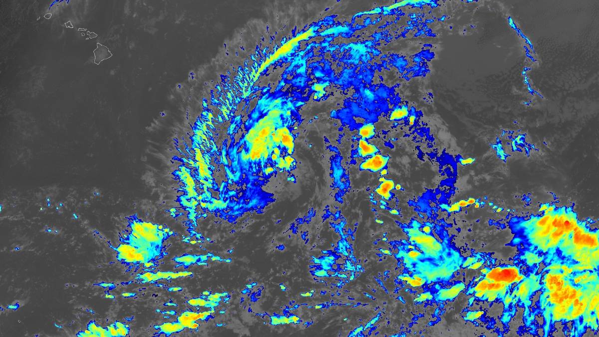
Updated 7:48 p.m. Thursday, Aug. 20, 2026.
Itʻs now Tropical Depression Two-C, but the system is expected to become a strong tropical storm this weekend by the time its forecast track takes it south of the Big Island.
“This is not the same as Lala,” reassured National Weather Service Warning Coordination Meteorologist John Bravender during a press conference Thursday. “Looks like the track is going to be a little [farther] south and the wind field is not as large.”
But the message from Bravender, who was with Hawaiʻi Gov. Josh Green during the press conference, is that people — for the second time in less than 2 weeks — should prepare now for any possible impacts.
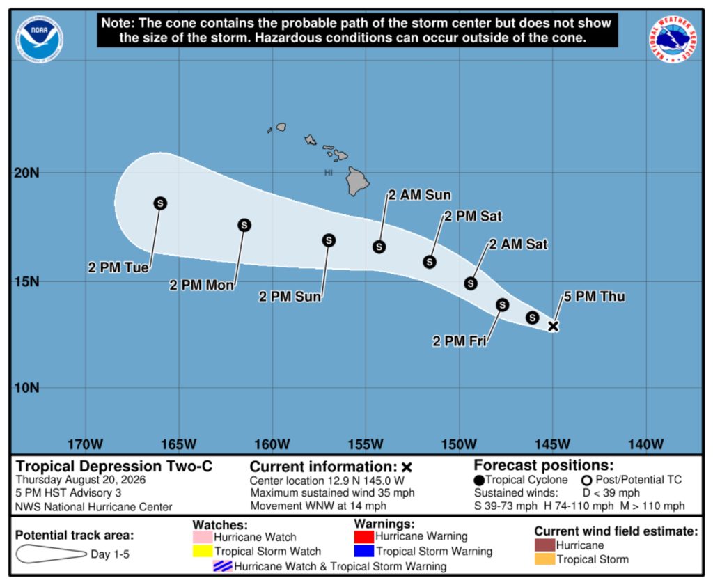
Tropical Depression Two-C as of an early Thursday evening update from National Hurricane Center forecasters had sustained winds of 35 mph and was about 815 miles east-southeast of Hilo, traveling north-northwest at 14 mph.
That general motion is expected to persist during the next few days, with a gradual turn to the west thereafter and the center of the storm passing south of the Big Island by this weekend and then the smaller main Hawaiian Islands, including Kauaʻi, by early next week.
It is expected to strengthen during the next 2 days to a high-end tropical storm. Wind speeds of 39 to 73 mph are classified as tropical storm force winds.
The most severe hazards will likely be additional heavy rainfall for some locations, possibly dangerous swells and potentially some wind.
Unfortunately, the developing tropical storm likely will have the greatest impact on some of the same Big Island areas devastated less than a week ago by Hurricane Lala. That storm killed 2 people while damaging or destroying a reported 263 homes and 18 businesses on Hawaiʻi Island.
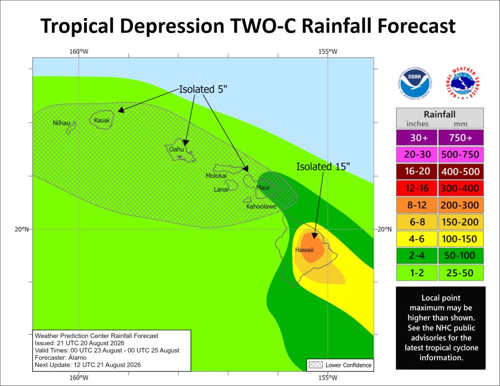
While the heaviest rainfall from the new storm is forecast on the Big Island, a total of 1 to 2 inches of rain are possible, with maximum amounts of up to 5 inches possible in some locations, late this weekend and into early next week for most of the other islands, including Kauaʻi.
That might not seem like an unusual amount, but it still could produce flooding and other hazards, especially in areas of steep terrain and over locations still recovering from Lala.
Swells generated by the storm also are expected to affect portions of the Hawaiian Islands by this weekend, and could cause life-threatening surf and rip current conditions.
Keep an eye out for any advisories, watches or warnings issued by National Weather System forecasters in Honolulu as the storm approaches.
 Courtesy Graphic: National Hurricane Center and Central Pacific Hurricane Center website
- Courtesy Graphic: National Hurricane Center and Central Pacific Hurricane Center website
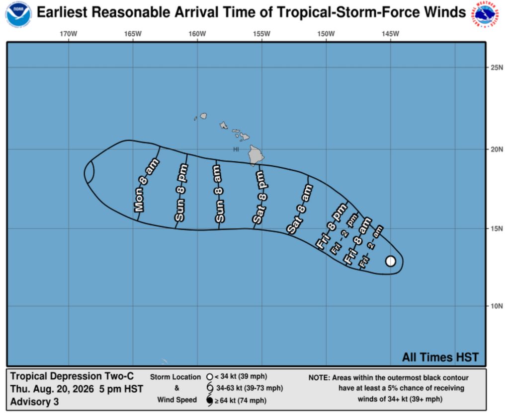
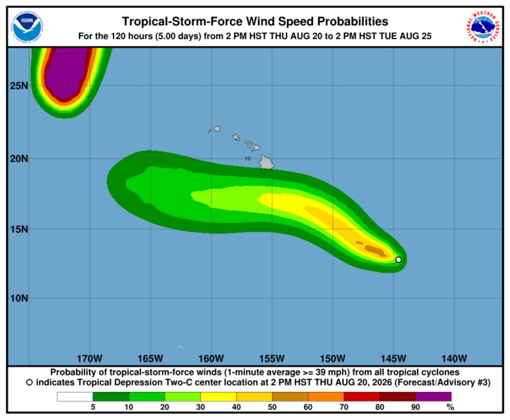
There also is a risk of wind impacts regardless of the exact track and intensity of the storm, with watches possibly necessary by Friday for portions of the Hawaiian Islands.
Again, residents should closely monitor the latest forecast updates from National Weather Service in Honolulu and ensure they have preparations in place.
Because it is expected to become a tropical storm in the Central Pacific, once it becomes a tropical storm, the cyclone will be named Tropical Storm “Moke,” a commonly used direct equivalent to the name “Moses” in historical Hawaiian records and family genealogies.
Two-C also is the closest of 3 tropical systems in the Pacific being monitored by forecasters.
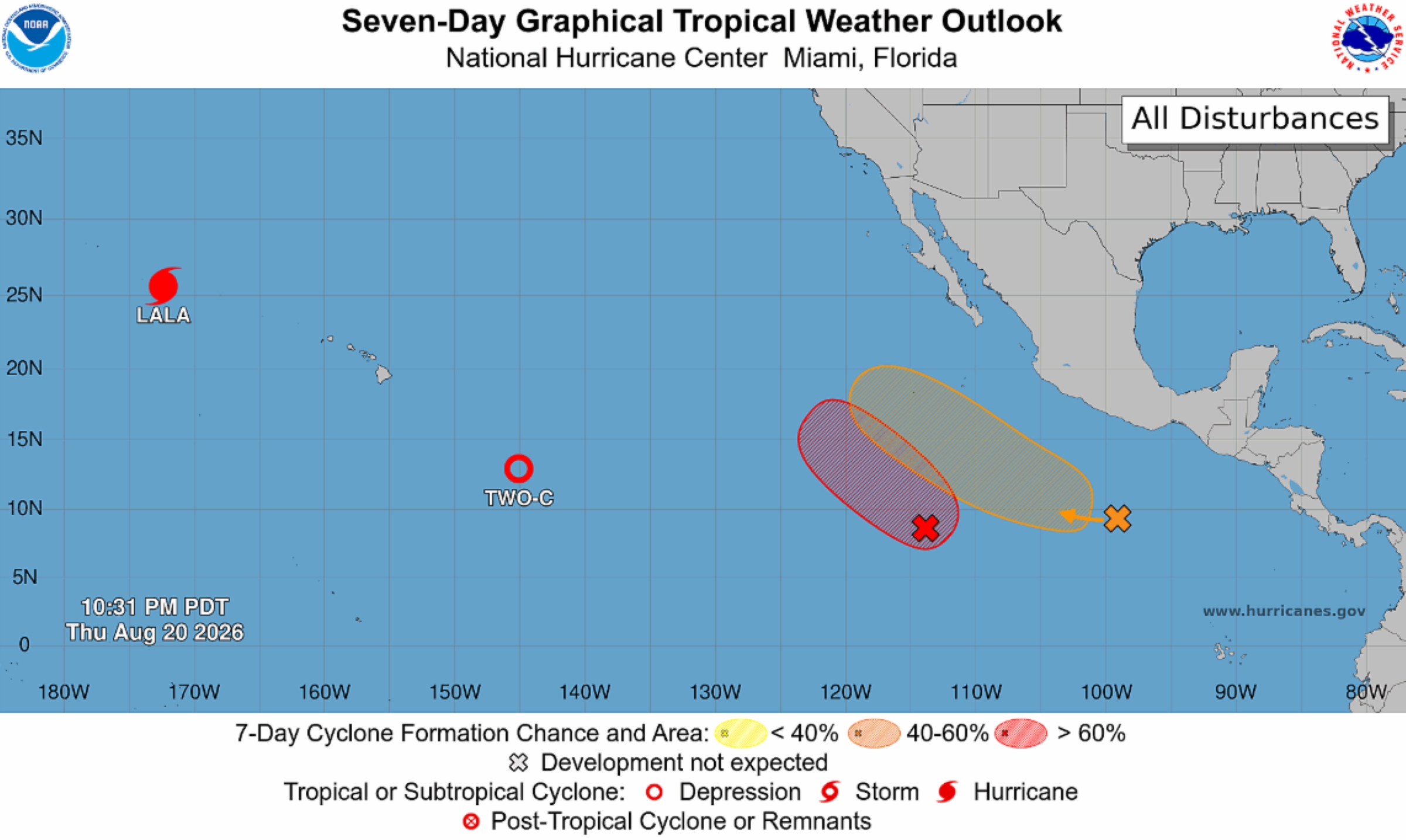
Disturbance 2 (in yellow on the above map) is a weak are of low pressure several hundred miles south of the southern tip of the Baja California Peninsula. It is producing a large area of disorganized showers and thunderstorms.
Environmental conditions are forecast to be marginally favorable for development. It has a 40% chance of developing into a tropical cyclone during the next 2 days and 60% chance during the next week as it moves west-northwestward or northwestward at 5 to 10 mph.
Disturbance 1 (in red on the above map) is located a few hundred miles south of the coast of southern Mexico. It is producing gusty winds and disorganized showers and thunderstorms.
Environmental conditions appear favorable for this tropical wave also to gradually development. A tropical depression is likely to form this weekend or early next week while the system moves west-northwestward, remaining well offshore of Mexico.
It has a 20% chance tropical cyclone formation within the next 2 days and 70% chance of formation during the next week.