


Updated at 8 p.m. on Aug. 14.
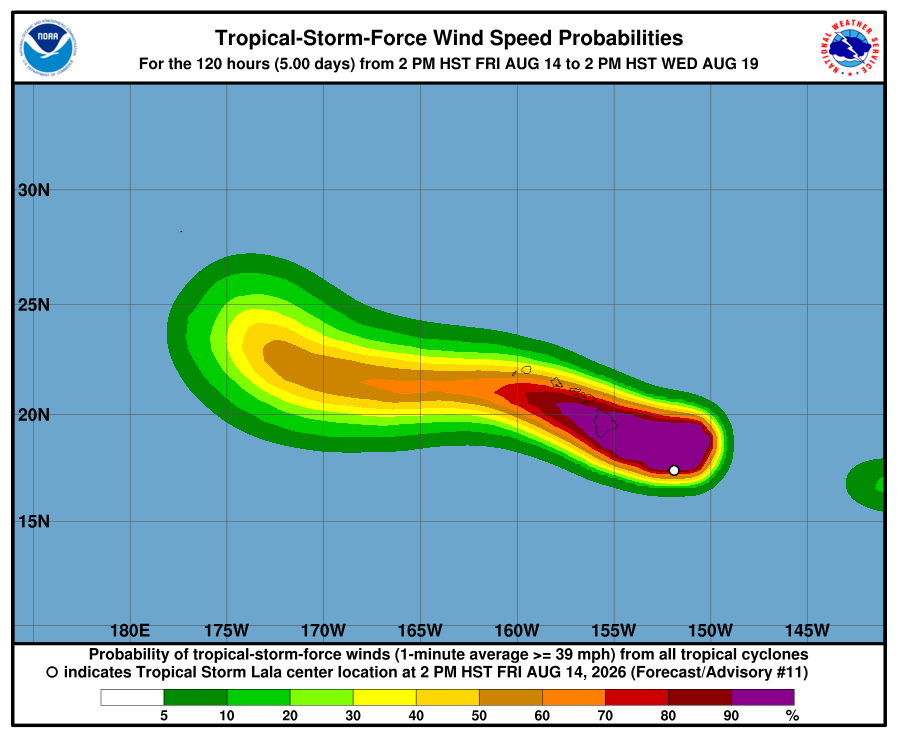
Kaua‘i County is under a tropical storm warning, with high winds and rain from Tropical Storm Lala expected to arrive early Sunday morning into early Monday morning, according to the National Weather Service.
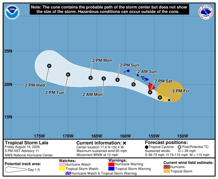
Lala is expected to strengthen into a hurricane before it makes landfall over or near the southern end of the Big Island on Saturday and pass south of Kauaʻi and Niʻihau and the rest of the Hawaiian Islands on Sunday into Monday.
The storm is now 200 miles east-southeast of South Point on the Big Island and moving 13 mph with sustained winds of 65 mph and higher gusts.
Lala also is bringing big waves. The National Weather Service has issued a high surf advisory for east-facing shores of Kauaʻi from 6 a.m. Saturday to 6 a.m. Sunday.
According to the National Weather Service, tropical storm-force winds are expected within the areas of Waimea, Barking Sands and Hanapēpē within the next 36 hours.
Peak winds for Kauaʻi are forecast at 25 to 35 mph with gusts to 45 mph. But there is potential for wind up to 57 mph.
Large breaking waves of 8 to 12 feet are forecast. Medium-period swell will quickly build tonight through Saturday as Tropical Storm Lala approaches from the east.
A flood watch also is in effect with peak rainfall amounts of 1 to 3 inches, with locally higher amounts.
Maui County, including the islands of Maui, Lānaʻi, Molokaʻi and Kahoʻolawe, and Oʻahu also are under a tropical storm warning.
Tropical-storm-force winds extend outward up 220 miles from the center.
Central Pacific Hurricane Center forecasters say preparations to protect life and property on the island should be rushed to completion.
The National Weather Service now has upgraded an advisory to a high surf warning for east-facing shores of the Big Island through Saturday night.
Medium-period swell generated by Tropical Storm Lala will begin to quickly build Friday night. By Saturday morning, east-facing surf for the Big Island increases to warning criteria.
Residents and others elsewhere throughout the main islands and in Papahānaumokuākea Marine National Monument should keep monitoring Lala’s progress.
On Kauaʻi, Department of Public Works crews at the district baseyards have begun storm preparations, including clearing ditches, cleaning drains and checking and fueling equipment.
On Friday and Saturday, crews will pre-stage equipment in flood-prone areas so they can respond quickly if flooding or other storm impacts occur. County crews are also preparing signs, cones, barricades and electronic message boards for deployment during road closures, traffic control and public alerts as conditions change.
Expected hazards from Lala
- Wind: Hurricane conditions are expected on the Big Island of Hawaiʻi on Saturday, with tropical storm conditions expected in Maui County Saturday night. Tropical storm conditions are possible in Oʻahu and Kauaʻi counties on Sunday. Wind speeds atop and on the windward sides of slopes and mountains are often up to 30 percent stronger than the near-surface winds indicated in this advisory, and in some elevated locations could be even greater.
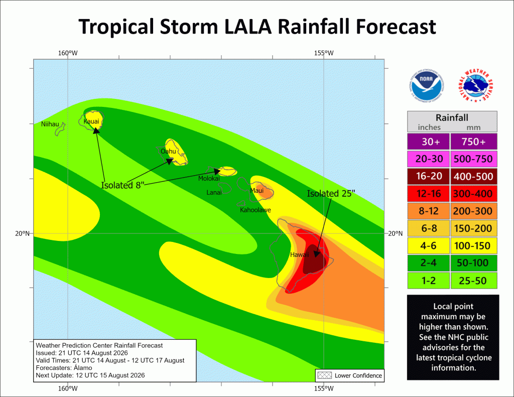
- Rainfall: Tropical Storm Lala is expected to produce rainfall totals of 8 to 12 inches across Maui and the Big Island, with maximum totals of 25 inches possible across the Big Island. Rainfall totals of 2 to 4 inches with maximum amounts of 8 inches is expected across the remainder of the island chain. This rainfall may produce life-threatening flooding and mudslides, especially in areas of steep terrain.
- Surf: Swells generated by Lala are expected to reach the east-facing shores of the state on Friday, spreading westward and building through the weekend. These swells are likely to cause life-threatening surf and rip current conditions.
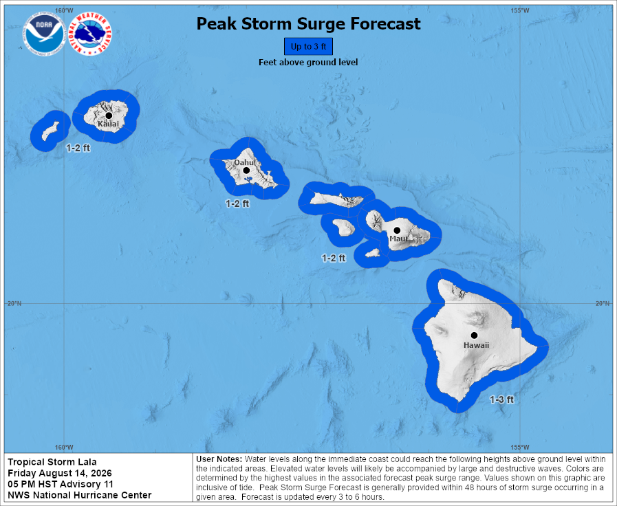
- Storm surge: The combination of a dangerous storm surge and the tide will cause normally dry areas near the coast to be flooded by rising waters moving inland from the shoreline. The water could reach 1 to 3 feet above ground in the indicated areas if the peak surge occurs at the time of high tide.
The deepest water will occur along the immediate coast, where the surge will be accompanied by large and dangerous waves. Surge-related flooding depends on the relative timing of the surge and the tidal cycle, and can vary greatly over short distances.
- Isolated tornadoes: Twisters are possible around the Big Island, which could hinder execution or emergency plans, cause damage as well as power and communications disruptions. Roofs peeled off buildings, chinmeys toppled, mobile homes pushed off their foundations or overturned, large tree tops and branches snapped off, shallow-rooted trees knocked over, moving vehicles blown off roads and small boats pulled from moorings are all potential impacts from a tornado if one should strike.
Visit the National Weather Service Honolulu forecast office website to check on specific storm details for expected storms hazards your area plus any advisories, watches or warnings among additional forecast information.

