

Volcano Watch is a weekly article and activity update written by U.S. Geological Survey Hawaiian Volcano Observatory scientists and affiliates.
As Hilo was bustling with activity for the 63rd annual Merrie Monarch Festival on the east side of the Big Island, Kīlauea was brewing for Episode 44 of lava fountaining, which happened for 8.5 hours the day that the renowned hula competition began.
Lava began to flow from the south vent in Halemaʻumaʻu the morning of April 3 and continued intermittently until fountaining started at 11:10 a.m. April 9.
It’s likely this extended period of precursory activity contributed to the delayed start of Episode 44. Interestingly, while more than 50 precursory lava flows came out of the south vent, only the north vent erupted lava fountains, which reached a maximum height of about 800 feet.
About half as much lava erupted during Episode 44 as during Episode 43.
The eruption plume reached 15,000 feet above sea level and did not extend through the inversion layer. It was transported to the north-northeast by southerly winds, with pieces of tephra softball-sized and larger falling on Hawaiʻi Volcanoes National Park, Kilauea Military Camp, Highway 11 and parts of Volcano Golf Course and Volcano Village.
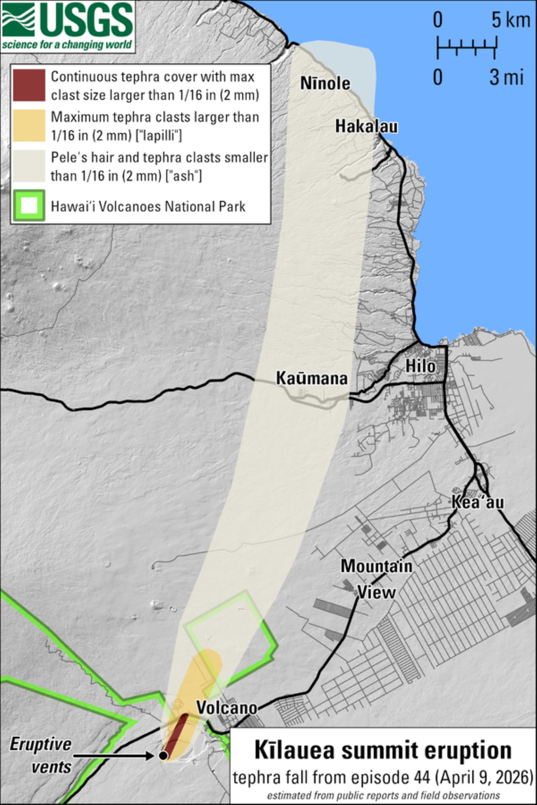
Despite the relatively low fountains and plume, ash and Pele’s hair was reported as far as Nīnole, about 35 miles away in North Hilo.
The Volcano Alert Level/Aviation Color Code for Kīlauea was raised to Warning/Red given the hazardous conditions on the ground and in the air being created by the fallout and plume.
Parts of Hawaiʻi Volcanoes National Park and Highway 11 were temporarily closed where tephra was falling and as it was cleared.
After the episode ended, Kīlauea was lowered to Advisory/Yellow indicating volcanic activity decreased significantly but continues to be closely monitored for possible renewed increase.
Measuring volcanic gas emissions during the episodic eruption has been difficult given that the predominant downwind direction during trade winds resulted in Crater Rim Drive being buried under tephra and no longer drivable.
Gas monitoring stations also were partially buried or damaged by tephra fall.
The southerly kona winds during Episode 44 pushed the plume over Highway 11, which allowed for measurement of sulfur dioxide emission rates averaging more than 200,000 tonnes per day. This value — which is comparable to the 2018 lower East Rift Zone eruption — suggests past episodes when both vents erupted higher volumes of lava might have had even higher emission rates.
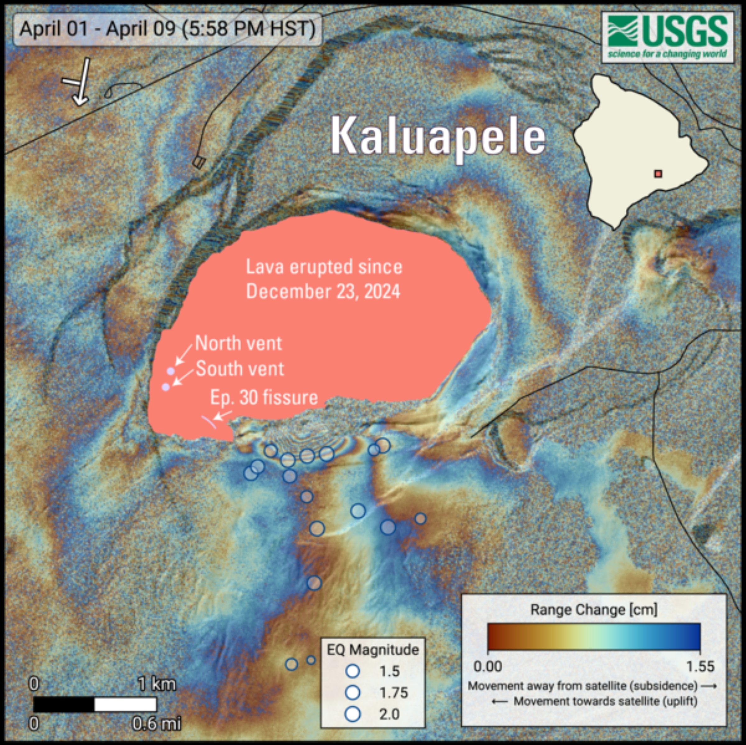
Part of the way through Episode 44 fountaining on April 9, earthquakes began occurring just south of Halemaʻumaʻu.
Between 4 p.m. and midnight, there were 15 shallow earthquakes size magnitude-2 or smaller, extending 0.6 of a mile to 1.2 miles below the south rim of the caldera.
Though the events were small, some were large enough to be felt by Hawaiian Volcano Observatory staff in the area at the time. This region was showing some sparse small earthquakes during the past few weeks to months.
Satellite-based observations also show that the area on the south rim of the crater, above where the earthquakes occurred, moved upward — possibly by as much as 5 inches.
The origin of this deformation is not known for certain, and Hawaiian Volcano Observatory will be monitoring this area for signs that this pattern is repeating or extending. It is a reminder of the hazardous and dynamic nature of the closed area in Hawaiʻi Volcanoes National Park.
Episode 44 might have some significance in comparing the ongoing episodic eruption at the summit of Kīlauea to previous episodic eruptions.
While there were 47 episodes at the start of the Puʻuʻōʻō eruption before activity transitioned to effusive lava flows, only 44 of those episodes came from the Puʻuʻōʻō vent alone; other episodes included lava erupting from the initial fissure system and nearby vents.
Likewise, the first episode in the ongoing eruption consisted of an initial fissure system that centralized to the north and south vents during subsequent episodes.
Smaller vents were also active in subsequent episodes but did not erupt the high fountains that now characterize the episodes from the north and south vents.
Comparing different eruptions can be a bit like comparing apples to oranges. But no matter how you compare, the ongoing eruption made an impression in terms of its longevity, with two active vents and impacts to areas downwind, including the changing topography of the summit.
The earthquakes and deformation associated with Episode 44 are a reminder that changes are always a possibility on an active volcano.
VOLCANO ACTIVITY UPDATES
KĪLAUEA volcano
USGS VOLCANO ALERT LEVEL: Watch
Kīlauea has erupted episodically within the summit caldera since Dec. 23, 2024. Episode 44 of summit lava fountaining happened for 8.5 hours April 9. No unusual activity has been noted along Kīlauea’s East Rift Zone or Southwest Rift Zone.
WHAT’S NEXT? Summit region inflation since the end of Episode 44 indicates another fountaining episode is possible; models suggest Episode 45 could begin between April 20 and 25, and could be preceded by precursory spatter and/or lava flows from the north and south vents.
MAUNA LOA volcano
USGS VOLCANO ALERT LEVEL: Normal
Mauna Loa is not erupting. Click here to read more from the volcano’s monthly activity report.
Hawaiian Volcano Observatory continues to closely monitor Kīlauea and Mauna Loa.
EARTHQUAKES
One earthquake was reported felt in the Hawaiian Islands during the past week:
- MAGNITUDE-3.5 earthquake at 10:44 a.m. April 12 located 7 miles south-southeast of Volcano at a depth of 3 miles.
Visit the Hawaiian Volcano Observatory website for past “Volcano Watch” articles, Kīlauea and Mauna Loa updates, volcano photos, maps, recent earthquake information and more. Email questions to askHVO@usgs.gov.
