

“Volcano Watch” is a weekly article and activity update written by Hawaiian Volcano Observatory scientists and affiliates. Today’s article was written by Hawaiian Volcano Observatory geologist Katie Mulliken.
Past “Volcano Watch” articles have summarized the episodic lava fountaining eruptions in Kīlauea’s recent history — within the past couple hundred years.
A look further back in the geologic record reveals that several lava fountaining eruptions similar to the ongoing one in Halemaʻumaʻu occurred within Kīlauea caldera within the past 500 years.
The Puʻuʻōʻō (1983–1986) and Maunaulu (1969) eruptions began with lava fountaining episodes like the ones on display intermittently at Kīlauea summit for over the past year.
These eruptions took place on the East Rift Zone, whereas the Kīlauea Iki (1959) eruption took place in a small crater next to Kaluapele (Kīlauea caldera). There, lava fountains built Puʻupuaʻi, a hill of tephra similar to the growing tephra mound from the ongoing eruption, on the crater rim.
No other puʻus exist on the caldera rim, but geologic deposits of tephra fall mapped in Kīlauea’s summit region indicate that high lava fountains erupted within Kaluapele around the years 1500, 1650, and in the first two decades of the 1800s.
These are part of a larger suite of deposits called the Keanakākoʻi Tephra, which retired USGS Hawaiian Volcano Observatory geologist Don Swanson spent much of his career characterizing.
Most of the Keanakākoʻi Tephra was created by fundamentally different types of explosive activity involving groundwater, making them unlikely to occur now. But within the Keanakākoʻi Tephra, three discrete deposits suggest that similar high lava fountains erupted previously within Kaluapele.
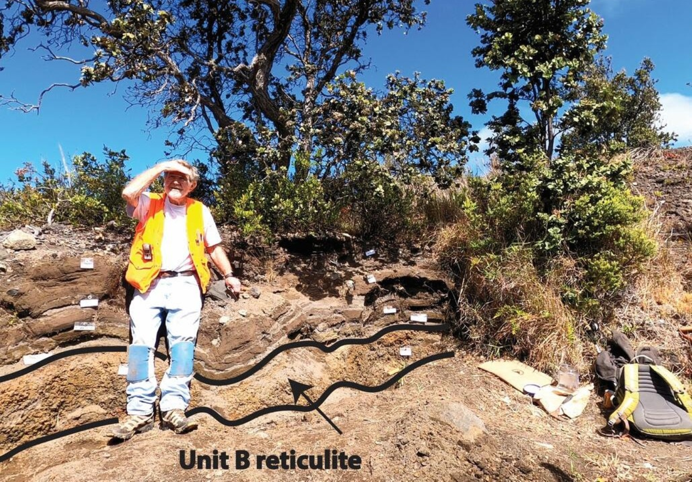
The oldest is a deposit formed of pieces of tephra that consist of more than 95% bubbles—essentially a lava foam called reticulite — that erupted around 500 years ago and is present below ground in areas of the Volcano Golf Course subdivision and Volcano village.
Named unit B, the eruption that produced this deposit occurred after formation of the present-day caldera, though the caldera was probably much deeper than it is currently.
These lava fountains could have been associated with lava flows within the caldera, similar to how the ongoing eruption in Halemaʻumaʻu produces tephra and lava flows inside the caldera. Around the time of this eruption, there was a brief eruption near Kilauea Military Camp, and the unit B tephra is found both below and above this lava flow.
Unit B is usually about 4 inches (10 cm) thick, but it can be thicker close to the caldera, and it is separated into six discrete subunits potentially erupted from different vents within Kaluapele or the same vent at slightly different times (like the ongoing episodic eruption).
The deposits are distributed completely around the caldera but are thickest to the northwest and northeast of the summit caldera, suggesting that they were produced by lava fountains reaching more than 1,900 ft (600 m) above the vents possibly during the winter months, when Kona winds were blowing.
Another deposit formed during an eruption around the year 1650 and is found to the east, southeast, and south of Kaluapele.
This deposit was also sourced from lava fountains within the caldera, possibly from a single vent or several contemporaneous vents (unit E). It’s mostly made up of scoria, which is tephra that has 50–90% bubbles, but is also crystal-rich.
The deposit is as thick as 21 in (53 cm) just north and northwest of Keanakākoʻi Crater and its distribution to the southeast, reaching as far as the coastline, suggests that the eruption was powerful, producing an eruptive plume that reached jet stream elevations.
Pumice is another word for tephra that is made up of 50–90% bubbles.
Two other pumice-rich deposits are mainly distributed to the south and southwest of Kaluapele and were the result of lava fountaining eruptions within the caldera sometime in the early 1800s (units K1 and K2). Unit K1, the older of the two and sometimes referred to as the “golden pumice,” is up to 12 in (30 cm) thick in some areas west of the caldera and it thins rapidly to the southwest. Unit K2, sometimes referred to as the “eastern pumice”, has a maximum thickness of 7 in (18 cm) near Keanakākoʻi Crater and it contains distinctive Pele’s hairs and tears near its base.
This deposit thins and grain size decreases rapidly to the southwest of Kaluapele.
These tephra deposits are like clues from Kīlauea’s past, telling us that the current eruption style is not unprecedented for the volcano’s summit region.
As we document and measure the ongoing lava fountaining eruption, we can better understand and interpret these deposits from the past.
Volcano Activity Updates
Kīlauea has been erupting episodically within the summit caldera since December 23, 2024. Its USGS Volcano Alert level is WATCH.
Episode 43 of summit lava fountaining happened for 9 hours on March 10. Summit region inflation since the end of episode 43 indicates that another fountaining episode is possible; models suggest that episode 44 could begin between now and April 15, with precursory lava flows ongoing since the morning of April 3. No unusual activity has been noted along Kīlauea’s East Rift Zone or Southwest Rift Zone.
Mauna Loa is not erupting. Its USGS Volcano Alert Level is at NORMAL.
One earthquake was reported felt in the Hawaiian Islands during the past week: a M4.0 earthquake 3 km (1 mi) E of Pāhala at 8 km (5 mi) depth on April 5 at 11:41 a.m. HST.
HVO continues to closely monitor Kīlauea and Mauna Loa. Visit HVO’s website for past Volcano Watch articles, Kīlauea and Mauna Loa updates, volcano photos, maps, recent earthquake information, and more. Email questions to askHVO@usgs.gov.
