

UPDATE: Kūhiō Highway near Hanalei River Bridge reopen to traffic; flood watch still in effect
Update at 12:04 p.m. Feb. 21, 2026: Kaua‘i Emergency Management reports that Kūhiō Highway near Hanalei River Bridge is reopen to traffic.
Officials also said that would be the final weather update the emergency management agency would release today (Feb. 21) unless other significant weather events happen.
The public is reminded that a flood watch remains in effect until 6 p.m. today for Kaua‘i and Ni‘ihau, meaning conditions will continue to remain favorable for further flooding from heavy rainfall throughout the day.
It does not, however, mean flooding will happen.
Update at 11:40 a.m. Feb. 21, 2026: The flash flood warning that was in effect until noon for Kaua‘i is canceled as flood waters have receded and heavy rainfall ended.
National Weather Service forecasters expect flooding to no longer pose a threat to the island.
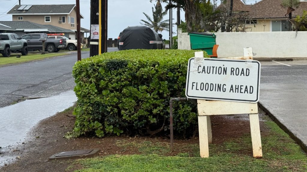
However, Kaua‘i Emergency Management officials report Kūhiō Highway near Hanalei River Bridge will remain closed until further notice because of elevated water levels.
The public is advised to stay tuned to local media for updates on road closures.
A flood watch also remains in effect until 6 p.m. today (Feb. 21) for Kaua‘i and Ni‘ihau.
Update at 9:49 a.m. Feb. 21, 2026: A flash flood warning in effect for the Garden Island will continue now until noon today as persistent heavy rainfall continues to cause ongoing flooding of rivers, streams and other low-lying areas as well as flash flooding in others.
National Weather Service forecasters in Honolulu say that radar indicated at 8:41 a.m. heavy rain showers over the island, with rain falling at a rate of 2 to 3 inches per hour observed offshore to the south of Kauaʻi and expected to move onshore yet this morning.
“Ponding, low visibility and other hazardous driving conditions are expected,” said Kauaʻi Emergency Management in its latest weather update. “If you must drive, please do so with extreme caution.
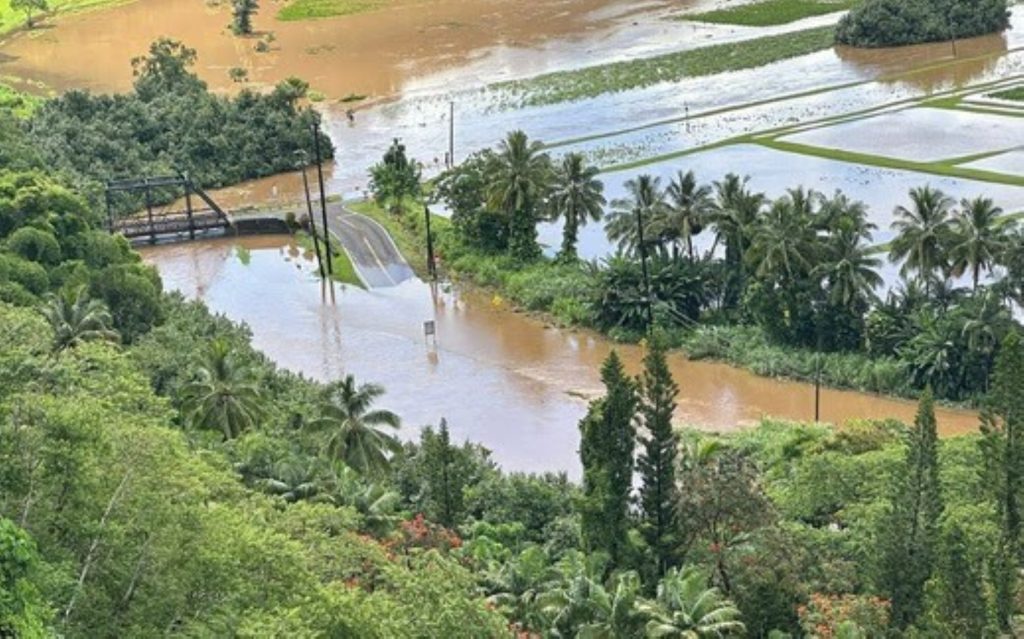
Hanalei River water levels also continue to be high enough to cause the closure of Kūhiō Highway near Hanalei River Bridge because of significant water over the roadway.
Kauaʻi Emergency Management reports the bridge and roadway will remain shuttered until further notice.
Officials advise the public to stay tuned to local media for updates about road closures. You can also call 808-241-1725; do not call Kaua‘i police or 9-1-1 unless you have an emergency.
The inclement weather is affecting services and utilities around the island now, too.
Kaua‘i County Public Works also reports that because of the inclement weather, Kapa‘a transfer station is not accepting green waste today.
Kaua‘i Island Utility Cooperative reports on social media that there is a power outage affecting co-op members in Hāʻena. An update from the utility cooperative at 8:45 a.m. today said because of flooding, its crews must wait until Hanalei River Bridge reopens.
“Plan on at least 4 hours for restoration … ,” the co-op’s message said. “We will provide more information and an updated estimated time of restoration as it becomes available. Mahalo for your patience.”
Call the National Weather Service automated weather line at 808-245-6001 or visit the National Weather Service Honolulu forecast office website for more weather updates.
Update at 7:58 a.m. Feb. 21, 2026: Kauaʻi will remain under a flash flood warning until likely at least 9 a.m. today (Feb. 21) as heavy rainfall causes ongoing flash flooding on the island.
Forecasters at the National Weather Service office in Honolulu extended the warning that went into effect early today as radar continued to show by about 5:30 a.m. heavy rainfall of up to 2 to 4 inches per hour.
Hanalei River water levels also are high enough that Kūhiō Highway near Hanalei River Bridge was closed because of significant water flooding the roadway.
Heavy rainfall began falling over windward portions of the island shortly before 3 a.m. today.
Forecasters said in a Friday afternoon (Feb. 20) email that the extended period of strong trade winds the state had been experience would come to an end that night, ushering in chances for heavy rain and thunderstorms, fueled by moisture moving east and west over the state meeting an upper level trough swinging through the northwestern islands.
Expect light and variable winds to generate isolated afternoon downpours and thunderstorms.
The risk for flooding should diminish Sunday.
Update at 3:52 a.m. Feb. 21, 2026: Kauaʻi Emergency Management officials notify the public that Kūhiō Highway near Hanalei Bridge is closed because of flooding.
National Weather Service forecasters said that waters of Hanalei River were already rapidly rising just before 3 a.m. today as heavy rainfall moved over windward portions of the island.
Kauaʻi County emergency management officials also say ponding, low visibility and other hazardous driving conditions are expected. They advise that if you must drive, do so with extreme caution.
Update at 3:28 a.m. Feb. 21, 2026: All of Kauaʻi is now under a flash flood warning until 6 a.m. today (Feb. 21) as heavy rain moves over windward sections of the island.
National Weather Service forecasters in Honolulu report radar indicated at 2:50 a.m. rain falling at a rate of 2 to 3 inches an hour.
Hanalei River also is rapidly rising. Water already reached a level that typically results in water running over the roadway and shuttering Kūhiō Highway near the bridge.
Flooding was expected to begin soon.
Heavy rainfall also is expected to cause flooding in drainages, streams, rivers, roads, properties and other low-lying areas.
Public road closures are possible in some areas. Landslides, rockslides and mudslides also are possible in areas of steep terrain.
The public is advised to stay away from streams, rivers, drainage ditches and culverts, even
if they are dry now. Do not cross fast-flowing or rising water in your vehicle or on foot.
Remember: turn around, don’t drown.
Also be especially cautious in the dark, when it is harder to recognize the dangers of flooding.
A flood watch in effect for the Garden Island and Niʻihau also was extended until 6 p.m. today
An upper level trough swinging through the northwestern islands today will continue to produce periods of heavy showers and isolated thunderstorms.
Additional flooding remains possible around both islands, especially on flood-prone roads and in other low-lying areas, which both could be closed because of elevated runoff and overflowing streams or rivers.
Urban areas also could receive more significant flooding and property damage because of rapids runoff.
The upper-level trough axis should lift north of the area later this afternoon, likely diminishing the flooding threat.
Story originally posted at 3 a.m. Feb. 20, 2026: The National Weather Service has issued a flood watch for Kauaʻi and Niʻihau, warning residents and visitors to prepare for the possibility of flash flooding from Friday afternoon through Saturday morning.
Forecasters say heavy rainfall, fueled by moisture moving over the state from both the east and west, along with an upper-level disturbance, could lead to rapid runoff and localized flooding.
Kauaʻi is expected to be the hardest hit, particularly in low-lying and flood-prone areas.
The flood watch goes into effect at 3:30 p.m. on Feb. 20 and will remain in effect until 6 a.m. on Feb. 21. Residents are urged to monitor updates and be ready to take action if flash flood warnings are issued.
Officials advise avoiding driving through flooded streets, keeping children and pets away from fast-moving water, and staying informed through local weather updates. Isolated thunderstorms are also possible over the western end of the state during this period.
The National Weather Service cautioned that conditions may deteriorate quickly and that residents should stay alert for potential emergency instructions.
To sign up for the county’s emergency notification service, the Wireless Emergency Notification System, visit the Kauaʻi Emergency Management Agency website.
Sponsored Content
