

National Weather Service forecasters in Honolulu didn’t mince their words in a weather briefing Wednesday afternoon.
Instead, they started with the bottom line.
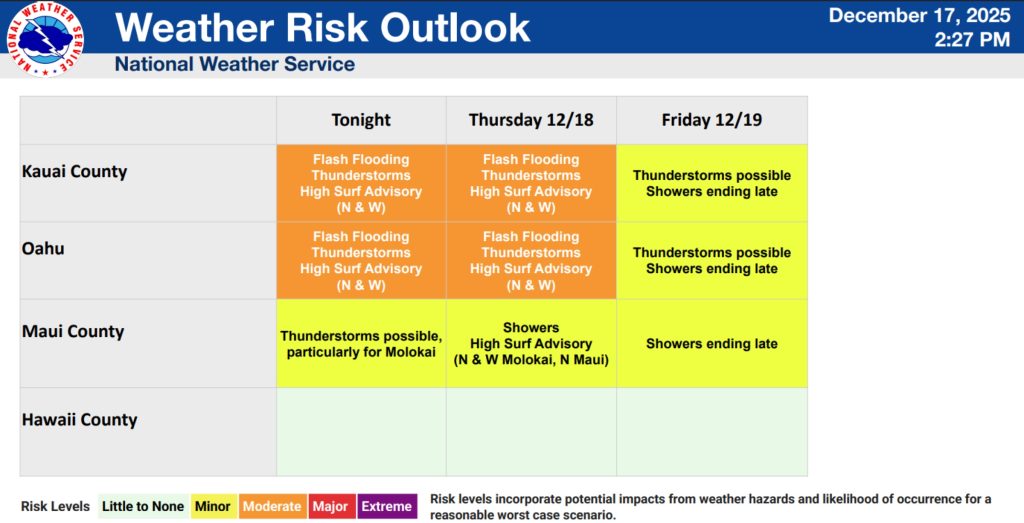
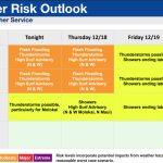
“The potential for heavy rain across Kaua‘i County and O‘ahu will continue through Thursday afternoon,” said the briefing materials sent by the forecast office. “Bands of showers training over the same areas could result in flooding concerns.”
Flash flooding is possible. Thunderstorms are also possible.
Kaua‘i County and O‘ahu remain under a flood watch through 6 p.m. today as the threat for heavy rainfall and flash flooding stands at a moderate level.
Forecast confidence is moderate, with periods of heavy rain likely; however, there is lower confidence in where flash flooding could occur. Thunderstorms continue to be possible into Friday, with rain expected to decrease to showers that are forecast to end later that day.
The northwest portion of Kaua‘i is expected to receive the most rain through 6 p.m. Friday, with much of the area forecast to get 1.5 to 2 inches of rain. There is a small portion of northwest Kaua‘i that is forecast to receive 2 to 3 inches of rain during the same time period.
Interior locations as well as south and eastern parts of the island could get anywhere from a quarter-inch up to 1.5 inches of rain through Friday evening.
So the island will be soggy. And any heavy rainfall will add to the flooding risk — and possibility of flash flooding.
Forecasters said the chance of heavy rainfall with the possibility of flash flooding will continue through Friday, but the best chance is throughout today, with a moderate risk of flooding on roads as well as in streams and poor drainage areas.
If a flash flood warning is issued, it means flash flooding is happening or imminent and there is a direct threat to life and property.

Forecasters advise the public to keep an eye on the weather and watch for updates, especially if there are any extensions or new advisories, watches or warnings issued.
A high surf advisory also remains in effect until 6 a.m. Friday for the north and west shorelines of the Garden Isle, Ni‘ihau and O‘ahu.
And a small craft advisory is in place for waters around Kaua‘i and O‘ahu, with seas of 10 to 12 feet forecast.
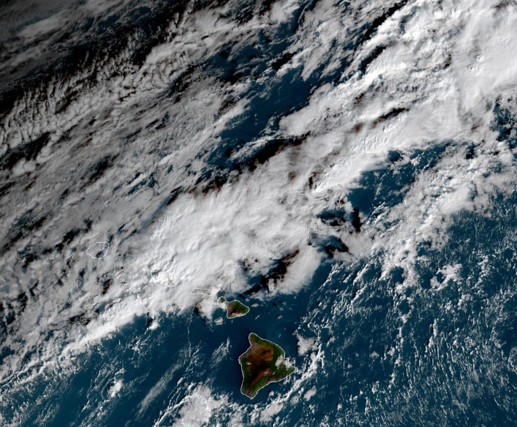
“An active weather pattern continues across the western portion of the state this morning as a weakening front remains stalled west of Kaua‘i,” said the National Weather Service in its 3:48 a.m. area forecast update for the state. “A band of clouds with heavy showers with isolated thunderstorms training from the southwest to northeast has remained nearly stationary over northern O‘ahu.”
Rainfall totals from overnight ranged from 1 to 3 inches.
High resolution models continued to suggest a band of showers to train over O‘ahu through much of the day while gradually becoming more diffused with a few stray showers reaching Moloka‘i.
“This band will shift northwestward later this morning and afternoon, keeping chances of heavy rain possible for O‘ahu and Kaua‘i,” the forecast said. “Southeast winds build in over Maui County and the Big Island.”
The flood watch will continue through this afternoon for Kaua‘i County and O‘ahu, and it could need to be extended through Friday morning for Kaua‘i as another upper level shortwave trough swings down, increasing instability over the Garden Isle.
“Depending on surface level convergence and where the lingering band of showers ends up this afternoon and evening, this pattern could reinvigorate an active shower pattern through the evening hours,” the forecast said.
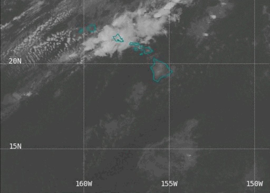
 Infrared satellite image from about 6:30 a.m. Dec. 18, 2025, taken by the National Weather Service forecast office in Honolulu.
- Image Courtesy: National Weather Service Honolulu forecast office
A low level ridge will build in Friday over the islands from the south, drawing low level moisture up to the mid levels, generating a mix of high-, mid- and low-level layered clouds.
“Best chances of showers will linger over the western half of the state, where the greatest upper level instability will linger,” said the early morning Thursday forecast.
Visit the National Weather Service Honolulu forecast office website to get the latest up-to-date weather forecast and information for your area.
News reporter Nathan Christophel contributed to this story.
