

Update at 9:04 a.m. Dec. 6, 2025: Surf heights declined to moderate levels — just below advisory level — earlier this morning along north and west shorelines of Kauaʻi and Niʻihau, so National Weather Service forecasters in Honolulu at about 3:30 a.m. canceled the high surf advisory that was previously in effect.
A threat of minor coastal flooding will continue through today and and Sunday morning (Dec. 7) as the moderate surf will continue to combine with monthly tides that are rising higher than predicted.
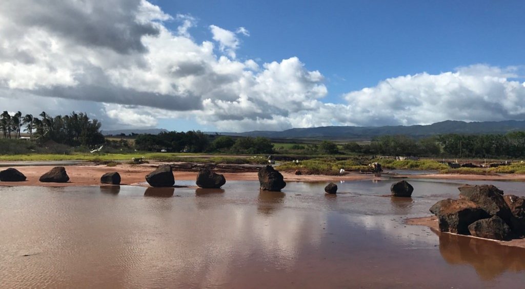
Brief periods of minor flooding are forecast along shorelines and in low-lying areas of the state during the early morning peak high tide.
Vulnerable low-lying coastal roadways, docks, boat ramps and other coastal infrastructure could see impacts from coastal flooding. Beaches that are normally dry also could be briefly inundated and coastal erosion is possible.
Forecasters remind the public:
- Avoid driving through flooded roadways.
- If you are forced to drive through salt water, be sure to rinse your vehicle with fresh water as soon as possible.
- Move electronics, vehicles or other valuables to higher ground.
- Monitor vessels to ensure mooring lines don’t get too tight and watch out for overwash around boat ramps.
- Secure canoes or other watercraft stowed on beaches.
Members of the public are encouraged to submit their coastal flooding photos to the University of Hawaiʻi Sea Grant College Program Hawaiʻi and Pacific Islands King Tides Project.
Update at 5:07 p.m. Dec. 5, 2025: Large surf will will continue to impact north- and west-facing shores of Kauaʻi and Niʻihau through tonight.
As a result, National Weather Service forecasters in Honolulu have extended a high surf advisory until 6 a.m. Saturday (Dec. 6) for those shorelines.
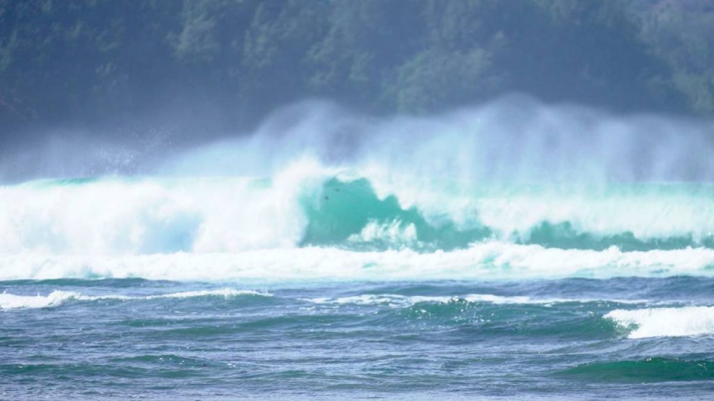
Large breaking waves of 12 to 16 feet are forecast for northern shorelines and up to 10 to 14 feet for west-facing shores.
A coastal flood statement also remains in effect until 8 a.m. Saturday.
A combination of that large surf and peak monthly tides that are coming in higher than predicted could lead to flooding along shorelines and in low-lying coastal areas.
Isolated minor coastal flooding will be possible, especially at and around daily peak high tide, which will be during the early morning hours.
Vulnerable low-lying coastal roadways, docks, boat ramps and other coastal infrastructure could be impacted by the expected coastal flooding. Beaches that are normally dry could be inundated as well, and minor coastal erosion is possible.
Strong breaking waves and strong currents in high surf advisory areas will make swimming dangerous.
Forecasters advise the public to:
- Avoid driving through flooded roadways.
- Rinse your vehicle with fresh water as soon as possible if you are forced to drive through salt water.
- Move electronics, vehicles and other valuables to higher ground.
- Monitor vessels to ensure mooring lines don’t get too tight and watch out for overwash around boat ramps.
- Secure canoes and other watercraft stowed on beaches.
- Heed all advice from ocean safety officials. Remember: when in doubt, don’t go out.
Original story posted at 10:14 a.m. Dec. 4, 2025: The National Weather Service has issued a minor coastal flood statement for vulnerable low-lying coastal roadways and a high surf advisory for north- and west-facing shores of Kauaʻi and Niʻihau, effective at noon today.
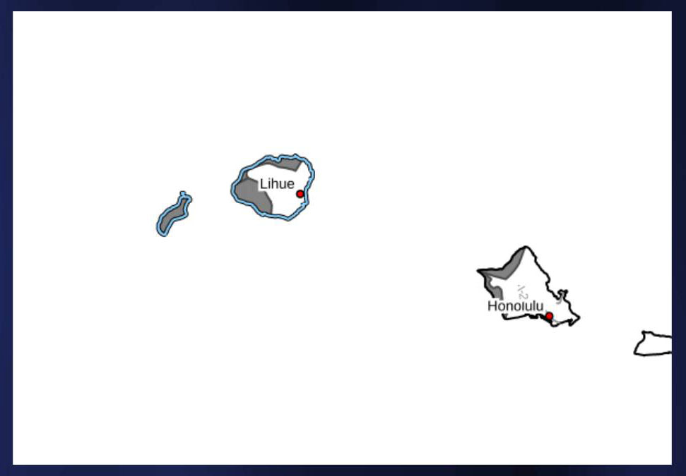
Forecasters predict large breaking waves of 10 to 16 feet along north- and west-facing shores of Niʻihau and Kauaʻi. Peak monthly high tides, combined with higher-than-predicted water levels, could lead to minor flooding along the shoreline and in low-lying coastal areas.
The minor coastal flooding statement and the high surf advisory will be in effect from noon through Saturday morning. Coastal flooding is possible around the daily peak high tide, which will occur during the early morning hours.
According to the National Weather Service, minor flooding could affect coastal infrastructure such as docks and boat ramps and beaches that are normally dry, with minor coastal erosion and saltwater inundation. Strong breaking waves and currents will make swimming dangerous.
Ocean safety officials advise motorists to avoid driving through flooded roadways and to move electronics, vehicles, and other valuables to higher ground. If compelled to drive through salt water, rinse vehicles with fresh water.
Monitor vessels to ensure mooring lines do not become too tight, and watch for overwash around boat ramps. Secure canoes and other watercraft stored on beaches.
To submit coastal flooding photos to the University of Hawaiʻi Sea Grant College Program’s Hawaiʻi and Pacific Islands King Tides Project, visit pacificislandskingtides.org.
