

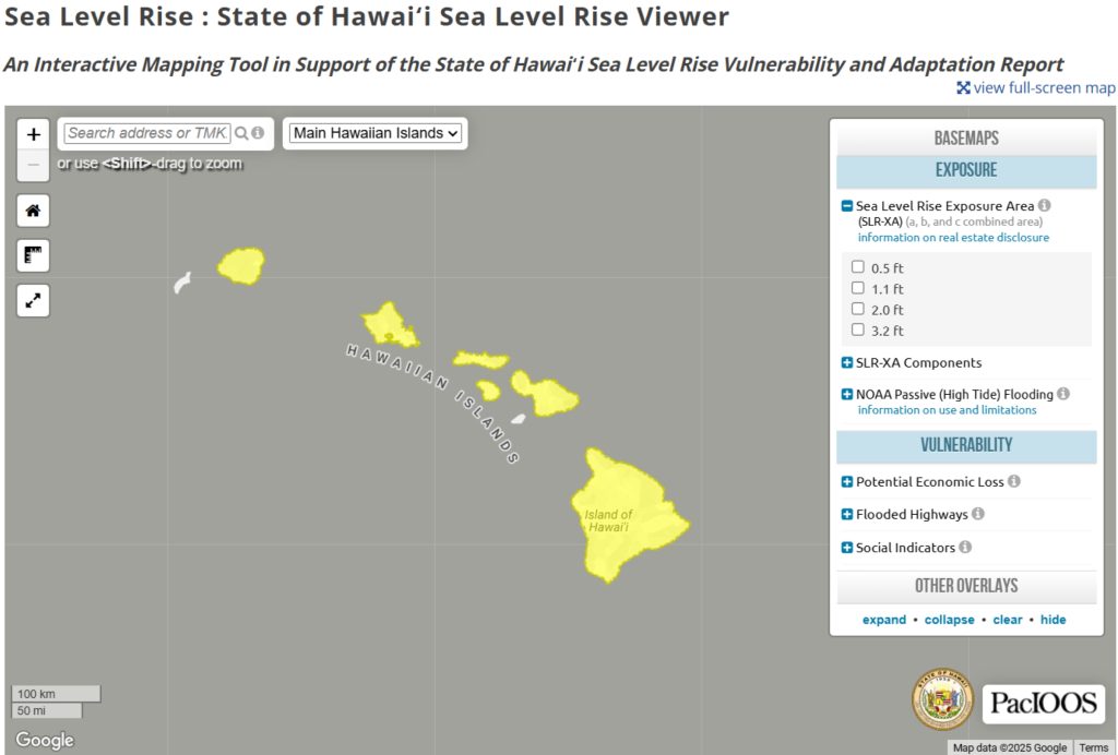
Hawaiʻi Climate Change Mitigation and Adaptation Commission recently launched an updated version of the State of Hawaiʻi Sea Level Rise Viewer, an online tool giving communities and local officials clearer insight into the growing threats facing the state’s coastlines.
Hawaiʻi is projected to experience 4 feet of sea level rise — up from 3.2 feet — by the end of this century. The Intergovernmental Panel on Climate Change says sea level rise will continue for thousands of years, even with drastic reductions in greenhouse gas emissions.
The viewer was developed through a partnership between the Pacific Islands Ocean Observing System, Coastal Research Collaborative at the University of Hawaiʻi and the University of Hawaiʻi Sea Grant College Program, along with Hawaiʻi Climate Change Mitigation and Adaptation Commission, Hawaiʻi Department of Land and Natural Resources and Hawaiʻi Office of Planning and Sustainable Development.
Improvements include expanded data, user-friendly guidance and social vulnerability indicators.
First released in 2017, this update seeks to help Hawaiʻi residents, planners and beachgoers get a better picture of how sea level rise could impact them at a range of projected heights.
A new feature is the addition of passive flooding layers between 4 and 8 feet from the National Oceanic and Atmospheric Administration, providing valuable information about high-tide still-water flooding in higher sea level rise conditions.
The viewer contains descriptions of the National Oceanic and Atmospheric Administration data as well as guidance on when to use different sea level rise scenarios and data sets from state sea level rise reports.
Updates also include the addition of a “social indicators” layer that allows users to view factors that can contribute to vulnerability from sea level rise impacts — such as houses built before 1970 — with household members 65-plus years old and those identified as low income.
Organizations can use this data to enhance community resilience and inform adaptation planning in coastal areas.
“Sea level rise isn’t a distant forecast — it’s happening now and its impacts are already being felt across Hawai‘i,” said State of Hawai‘i Climate Coordinator Leah Laramee in a state release about the viewer updates. “We need tools like the sea level rise viewer to make informed planning and policy decisions.”
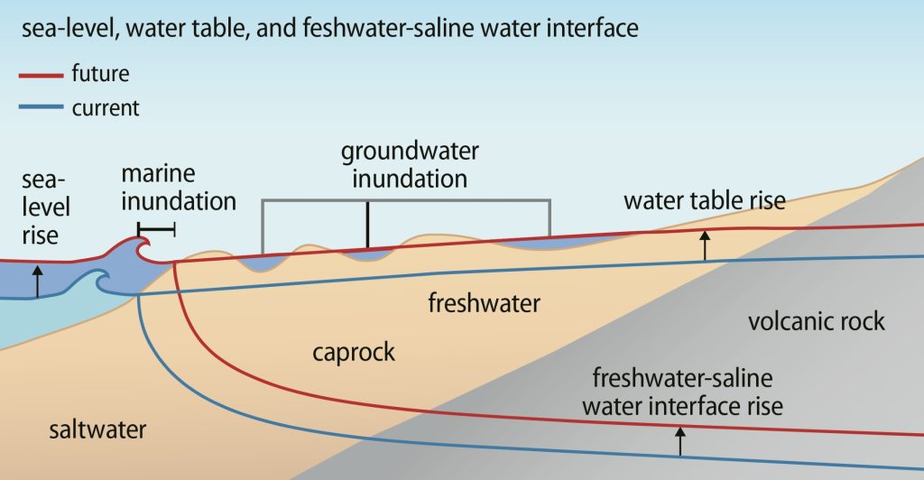
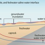
 Schematic diagram showing passive marine and groundwater flooding from current sea level (blue) to future sea level (red) (Adapted from Rotzoll and Fletcher 2012). (Image Courtesy: Pacific Islands Ocean Observing System website)
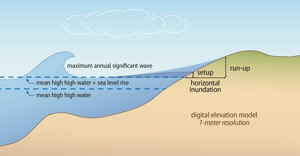
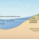
- Schematic diagram showing key inputs and outputs of modeling annual high wave flooding. (Image Courtesy: Pacific Islands Ocean Observing System website)
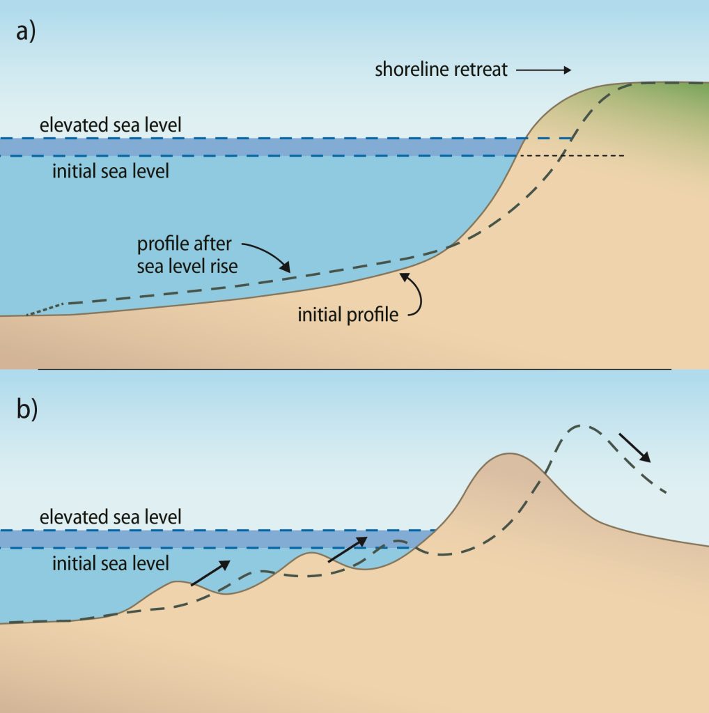
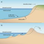
- Schematic diagram showing key inputs and outputs of modeling coastal erosion (top) and the change in shoreline profiles with sea level rise (bottom). (Image Courtesy: Pacific Islands Ocean Observing System website)
This update also takes steps toward addressing the many planning and design recommendations in the 2017 and 2022 Sea Level Rise Vulnerability and Adaptation Reports.
Hawaiʻi Climate Change Mitigation and Adaptation Commission is continuing those efforts, beginning work on a 10-year update to the 2017 Sea Level Rise Vulnerability and Adaptation Report.
“These updates give our communities and leaders clearer, more actionable information so we can plan smarter, protect people and respond to the realities unfolding along our shores,” Laramee said.
Check out the State of Hawaiʻi Sea Level Rise Viewer to learn more, discover what it has to offer and what you can learn by using it.
