

“Volcano Watch” is a weekly article and activity update written by U.S. Geological Survey Hawaiian Volcano Observatory scientists and affiliates.
The episodic eruption at the summit of Kīlauea volcano on the Big Island continues, with 36 episodes of lava fountaining so far since it began nearly a year ago on Dec. 23, 2024.
Let’s catch up on the events and hazards associated with the volcano’s most recent few eruptive episodes and review the current status of Kīlauea itself.
Fountaining episodes during the past month and a half broke several records for this eruption.
Recent episodes featured the highest lava fountains, the most volume of lava erupted and the highest rate of lava effusion for this event, which has now lasted more than 10 months.
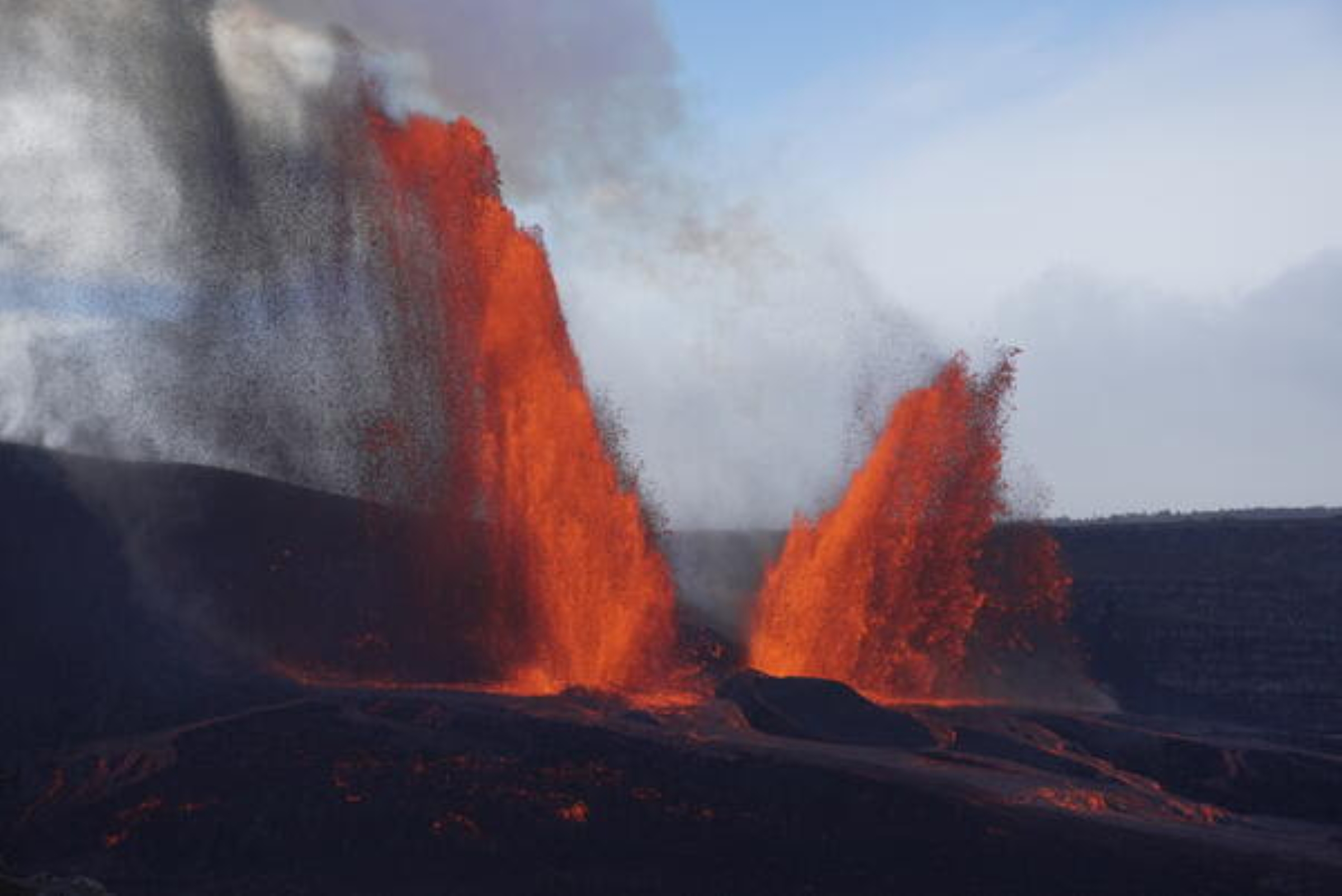
Episode 34 was characterized by inclined fountains from the north vent, which showered the crater floor with tephra, while the south vent fountains soared vertically to about 1,200 feet during the early morning of Oct. 1.
About 2.4 billion gallons of lava erupted during the 6 hours of Episode 34.
Episode 35 occurred overnight Oct. 17–18. Fountains at the north and south vents increased in height during the first two hours of the eruptive episode, with lava from the south vent reaching 1,475 feet — the highest lava fountain observed yet in this eruption — with the north vent fountains reaching only a few hundred feet lower.
The dual fountains geysered molten rock for about 7.5 hours, adding the greatest volume of all episodes in this eruption so far: 2.7 billion gallons of lava onto the crater floor, raising it by an average of about 9 feet.
Kīlauea’s summit region deflates when eruptive episodes are happening as magma previously stored within the volcano erupts onto the surface. The summit consistently inflates between eruptive episodes as magma again accumulates within shallow storage areas.
This pattern of inflation and deflation is what allows Hawaiian Volcano Observatory to forecast timeframes for when new eruptive episodes could start.
The summit resumed inflation after Episode 35 ended. Lava began to overflow from the south vent Nov. 4 as the window for when Episode 36 could start approached.
These overflows were driven by gas-piston events, which have been observed prior to the start of many episodes.
Magma develops a cooler crust as it rises inside the eruptive conduit beneath the vents, preventing gas within the molten rock from escaping.
The cooler crust is removed and gas-rich material below is exposed when magma rises enough to overflow, often spattering as it erupts. Eventually, conduit pressure subsides and the remaining lava drains back into the vent.
Overflows continued intermittently from both vents inside Halemaʻumaʻu Crater until mid-morning Nov. 9, when Episode 36 finally began.
The north and south vents erupted 2.1 billion gallons throughout the next 5 hours — one of the shortest episodes since the summit eruption started.
This amount of lava erupted during the short-lived Episode 36, however, makes it the eruptive phase with the highest rate of lava effusion so far.
Recent episodes also continued to add tephra to the growing cone on the rim of Halemaʻumaʻu Crater, with about 30 feet accumulated during Episode 36 alone.
The new cone has grown to a total of about 138 feet above the pre-eruption ground surface on the crater rim.
Tephra deposited during recent episodes also impacted nearby Hawaiian Volcano Observatory monitoring stations. Several monitoring stations were buried, needing to be manually dug out after lava fountaining ended.
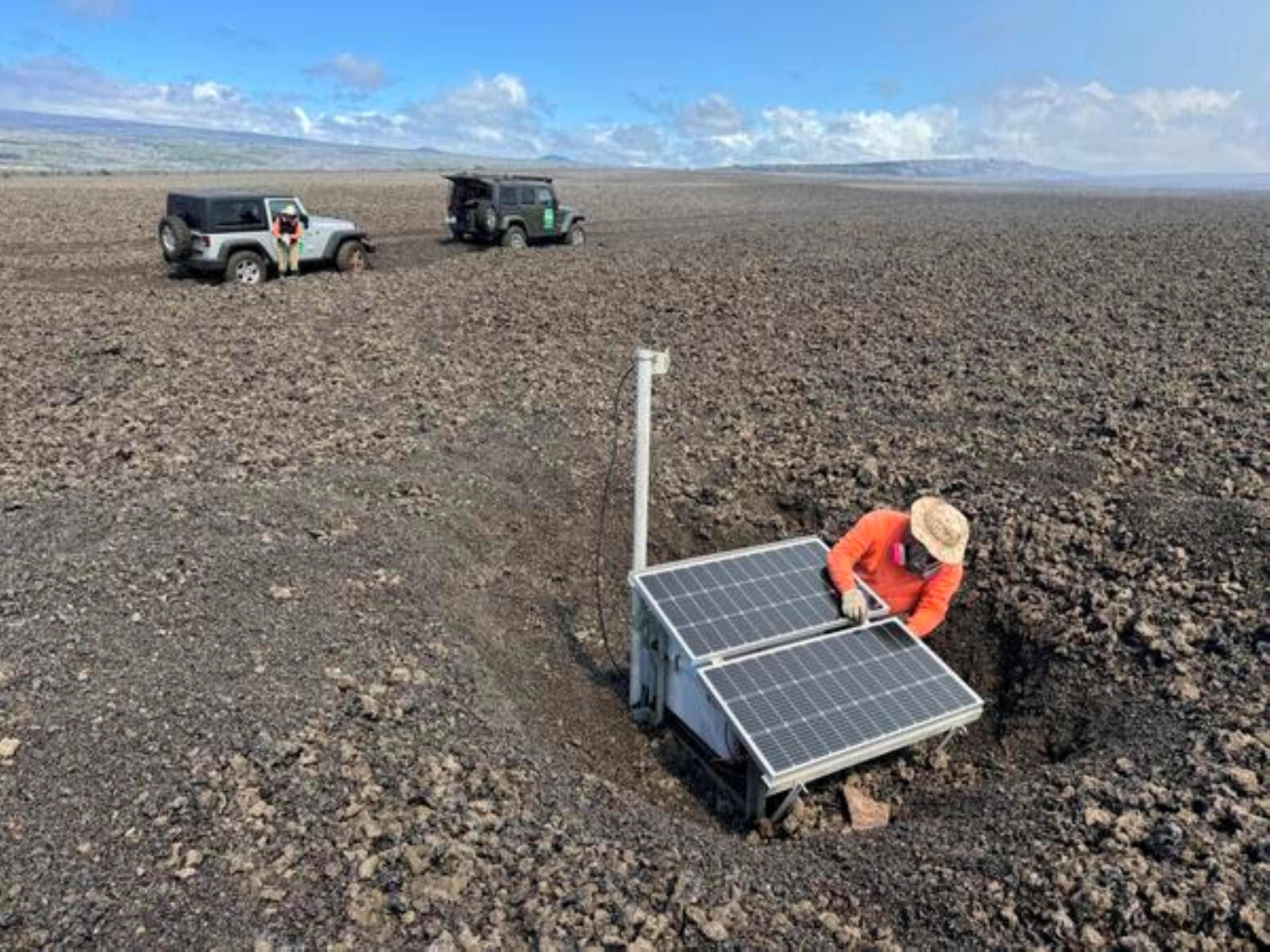
Solar panels that provide power to several stations downwind were broken and some camera equipment on the crater rim was partially melted as a result of the highest lava fountains during Episode 35.
High fountains and wind combined during Episode 35 to deposit up to fist-size tephra on Highway 11, prompting a advisory message about the roadway from Hawaiʻi County Civil Defense Agency. Pele’s hair was transported farther downwind, too, falling over and into southwestern Big Island communities.
Wind also carries elevated volcanic gas emissions during eruptive episodes, contributing to volcanic air pollution called vog.
As long as the pattern of lava fountaining deflating the summit during an eruptive episode is followed by changing to inflation after the episode ends, it’s likely the ongoing episodic eruption and its associated hazards will continue.
The forecast for when Episode 37 will begin calls for lava geysers to reappear — at the earliest — as Nov. 22.
Hawaiian Volcano Observatory continues to monitor Kīlauea closely.
VOLCANO ACTIVITY UPDATES
KĪLAUEA volcano
VOLCANO ALERT LEVEL: Watch
Kīlauea has erupted episodically since Dec. 23, 2024, within its summit caldera inside Hawai’i Volcanoes National Park.
Episode 36 lava fountaining happened during a period of 5 hours Nov. 4. Glow from the vents was observed overnight Nov. 12 into Nov. 13. No unusual activity has been noted along Kīlauea’s East Rift Zone or Southwest Rift Zone.
WHAT’S NEXT: The summit is reinflating, with forecast models indicating Episode 37 is likely to start between Nov. 22 and 29.
MAUNA LOA volcano
VOLCANO ALERT LEVEL: Normal
Mauna Loa is not erupting.
Seismicity rates increased by about 75% relative to October, according to the Hawaiian Volcano Observatory monthly Mauna Loa update Nov. 6; however, that rate is still within the volcano’s background levels. A total of 151 magnitude-1+ and smaller earthquakes were detected beneath Mauna Loa’s summit region, as well as 3 magnitude-2+ quakes and 1 magnitude-3+ earthquake.
Data from global positioning system instruments continued to show only minor inflation beneath the summit as magma replenishes the reservoir system and Mauna Loa recovers from its 2022 eruption.
Hawaiian Volcano Observatory continues to closely monitor Kīlauea and Mauna Loa.
EARTHQUAKES
No earthquakes were reported felt in the Hawaiian Islands during the past week.
Visit the Hawaiian Volcano Observatory website to find past “Volcano Watch” articles, Kīlauea and Mauna Loa updates, volcano photos, maps, recent earthquake information and more. Email questions to askHVO@usgs.gov.
Click here to learn even more.
