

This year’s dry season was wetter than usual for Kaua‘i.
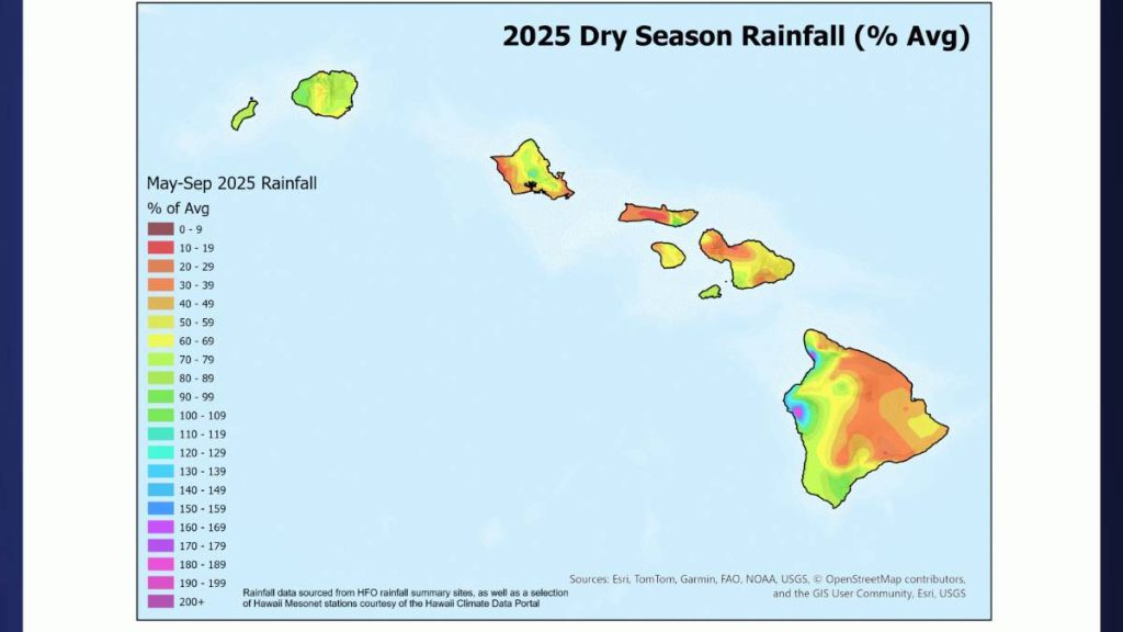
According to the National Weather Service in Honolulu, the rainfall during the dry season, which runs from May through September, was slightly above average on the Garden Isle, while less rain was seen on the Big Island, O‘ahu and Maui County.
In September, rainfall improved after August’s dismal showing, especially for Kauaʻi, though many parts of the state remain significantly below average for the year so far.
The typically dry leeward areas all came in above their monthly averages, with a few spots in the northwest portion of the island reaching 2 to 3 times higher. This was mainly the work of a few days of heavy rain near the end of the month, but still gave these areas some much-needed precipitation.
The September rainfall helped to make up some of the summer deficit, though only about half of the sites were near to above average to end the dry season, according to the September rainfall summary from the National Weather Service. The remaining year-to-date totals are mainly in the 60% to 85% range. The Mt. Waiʻaleʻale gauge still holds the highest year-to-date total for the island and the state as a whole with 232.09 inches, 79% of average.
Overall, the 2025 season ranked as the third driest in the last 30 years across the state, with 2010 being the driest and the 2007 season coming in second.
Drought conditions (D1 or greater) changed little in terms of areal coverage through the dry season, with around 70% of the state affected. Drought severity increased most significantly over the Hāmākua and Ka‘ū Districts of the Big Island, as well as the windward and leeward coasts of O‘ahu.
With the wet season officially here, the National Oceanic and Atmospheric Administration’s Climate Prediction Center reports La Niña Advisory in effect. These conditions emerged in September and are expected to continue through the January to February 2026 period, with a 55% chance that conditions will transition to the El Niño-Southern Oscillation cycle, where neither El Niño nor La Niña conditions are present.
These neutral conditions are predicted to continue through March.
According to the National Weather Service, rainfall is predicted to be consistent with a cold-season La Niña event, with the climate model consensus supporting enhanced probabilities for above-normal rainfall through early spring 2026, with the greatest probabilities over the northwestern half of the state.
Rainfall amount and distribution can be influenced by the strength of La Niña. Weaker La Niña events have generally favored above-normal rainfall during winter in Hawaiʻi in recent decades (since the 1980s), with the potential for more weather systems capable of producing widespread significant rainfall.
However, weather experts state that weak La Niña events do not necessarily result in Hawaiʻi’s wettest wet seasons on record.
