

Below average rainfall leaves county, state drier than normal
Almost every rain gauge recorded around or below 50% of the average rainfall totals for August.
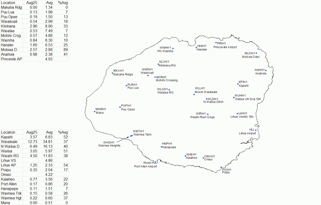
The highest reported totals were in higher terrain and windward slopes of the island, while leeward areas struggled to reach 20% of the August averages.
The Mount Waiʻaleʻale rain gauge recorded its driest August on record since its installation in 2003. However, it also had the highest monthly total at 12.73 inches, which is 37% of the average rainfall.
Mount Waiʻaleʻale’s monthly and highest daily totals were also the highest across the entire state for August. The site continues to hold the highest year-to-date total for Kauaʻi County and the state as a whole with 211.81 inches.
The majority of the state reported below-average rainfall totals for the month, except for a few modest rainfall events that helped some sites reach average or above.
On Aug. 6, humid conditions developed as the remnants of Tropical Cyclone Gil passed north of the islands, disrupting the trade winds and allowing land-sea breezes. The moisture brought 0.25 to 0.5 inches of rain over windward and some leeward slopes, including up to 0.3 inches in Kaʻū, which has been affected by drought.
Trade winds and drier weather returned until Tropical Cyclone Henriette passed north, bringing light winds, humid conditions, and only isolated showers on Aug. 10 and 11.
Moderate to breezy trade winds resumed from Aug. 12 to 24, with lower humidity and limited windward showers.
Between Aug. 25 and 27, a stalled surface low north of the islands created a hybrid pattern of east-southeast trade winds and land-sea breezes. This produced showers along east- and southeast-facing slopes of Hawaiʻi Island, while the rest of the state remained mostly dry.
From Aug. 28 to 31, another trough kept winds light to moderate with leeward sea breezes. The Kona coast saw the most rain to start, with 0.25 to 1 inch on Aug. 28 and 0.75 to 1 inch on Aug. 29.
A surge of deep tropical moisture, associated with a trough passing just south of the islands on the 30th and 31st, increased showers statewide, bringing 0.33 to 0.75 inches to windward areas on Hawaiʻi Island, Kauaʻi, Maui, and Oʻahu, with over 1 inch in the Koʻolau Mountains.
Sponsored Content
