

Volcano Watch: Discovery of massive submarine landslide near 1957 Aleutian earthquake epicenter
“Volcano Watch” is a weekly article and activity update written by U.S. Geological Survey Hawaiian Volcano Observatory scientists and affiliates.
As part of a growing national effort to understand seafloor hazards, scientists from the U.S. Geological Survey Volcano Science Center are working across agencies to investigate how submarine earthquakes, landslides and volcanic activity shape tsunami risk — not just in Hawaiʻi, but throughout the broader Pacific region.
A multi-agency expedition in June led by the U.S. Geological Survey, Bureau of Ocean Energy Management, National Oceanic and Atmospheric Administration, Smithsonian and Woods Hole Oceanographic Institution explored more than 2,200 miles of the Aleutian margin aboard the Office of Naval Research vessel Atlantis.
U.S. Geological Survey geophysicist and oceanographer Ashton Flinders with Hawaiian Volcano Observatory led the volcano, earthquake and landslide hazard component of the expedition.
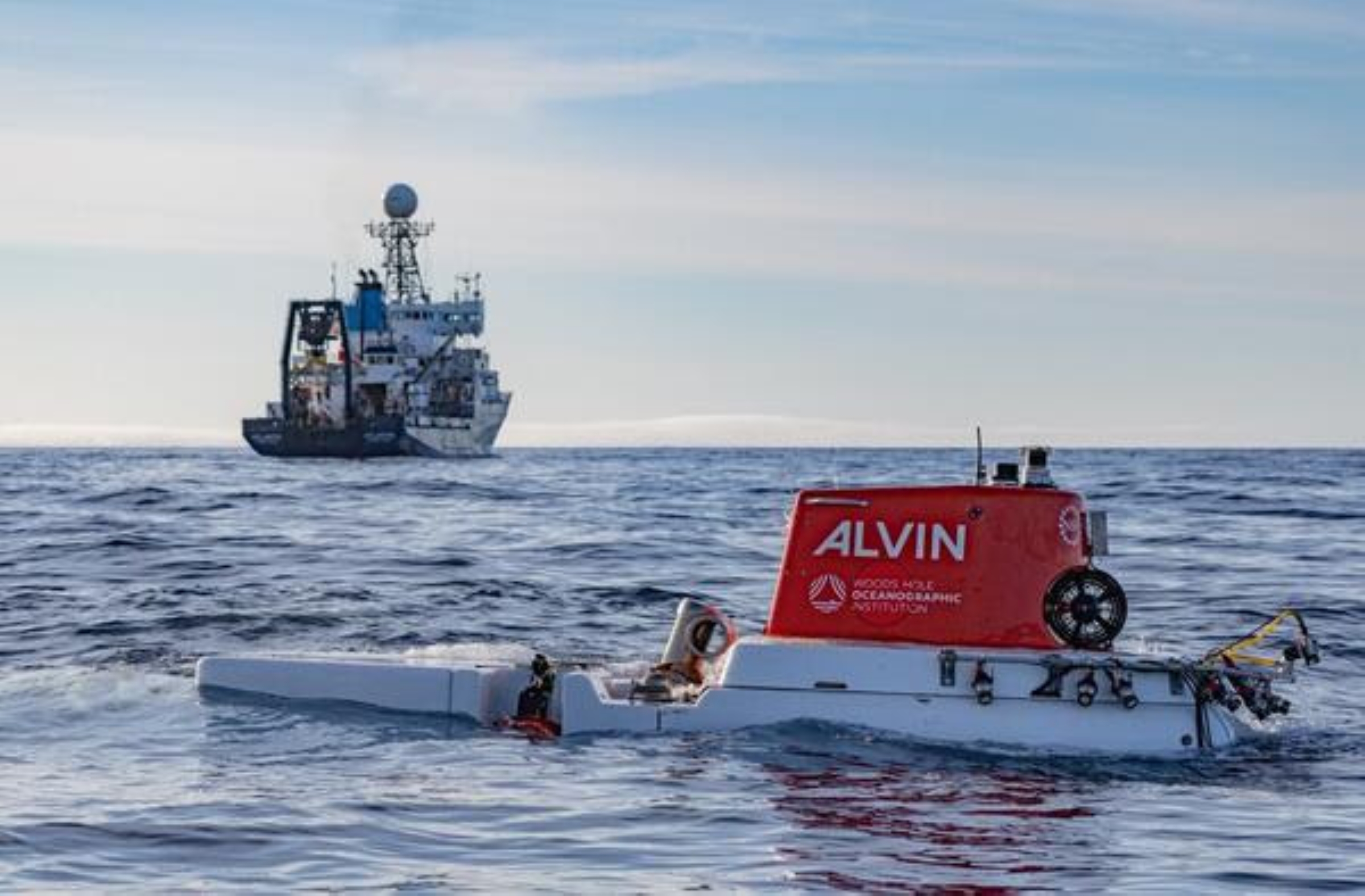
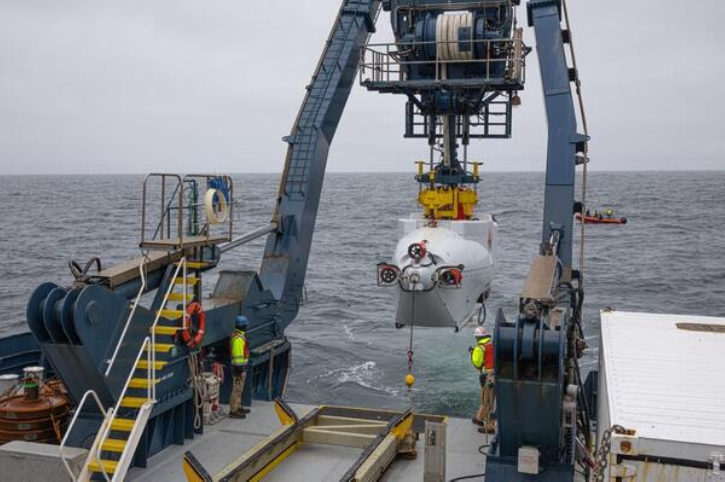
Using the U.S. Navy’s human-occupied vehicle Alvin, the mission focused on understanding how tectonic activity, submarine volcanoes and deep-sea ecosystems interact to shape geologic hazards and ocean-floor habitats.
Alvin is a deep-diving submarine capable of carrying two scientists and a pilot to depths of more than 20,000 feet to explore and sample the seafloor.
The human-occupied vehicle underwent numerous upgrades, including a major retrofit completed in 2022, and since launch in 1964 played a key role in historic missions such as the exploration of the RMS Titanic wreck and hydrothermal vent discoveries.
A highlight of the Aleutian margin mission included Flinders’ dive to 5,300 feet below the ocean surface on the flanks of Bogoslof volcano to investigate its eruptive history and submarine structure.
Flinders’ team collected 884 scientific samples — including 444 biological specimens, 29 geologic samples and hundreds of liters of seawater — throughout the course of their expedition.
The Atlantis traveled nearly 2,200 miles, with the ship’s multi-beam sonar mapping more than 2,500 square miles of previously uncharted seafloor.
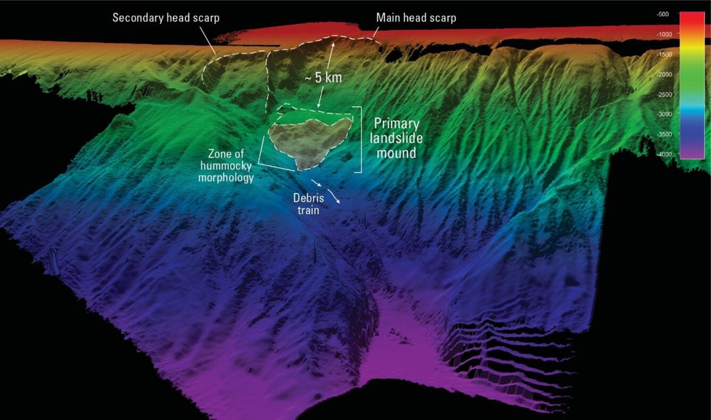
Among the most significant discoveries was a massive submarine landslide structure along the southern slope of the Aleutian Shelf, about 10 miles northwest of the epicenter of the 1957 Andreanof Islands earthquake.
It spans more than 10 miles across and exhibits classic signs of rapid slope failure: a scalloped headwall, chaotic debris zone and long runout lobes descending toward the deeper basin.
The magnitude-8.6 earthquake struck March 9, 1957, and produced a Pacific-wide tsunami that devastated parts of Alaska and Hawaiʻi.
Waves reached 53 feet at Hāʻena, Kauaʻi, and up to 12 feet in Hilo Bay, and caused millions of dollars in damage throughout the Hawaiian Islands.
Seismic and tsunami models raise questions about whether a submarine landslide helped generate the large runups observed, similar to the April 1, 1946, tsunami that caused $26 million in damage — which would be nearly $429 million today — and a total of 162 fatalities in Hawaiʻi.
The 1946 tsunami was caused by a magnitude-7.4 earthquake in the Aleutian Islands — south of Unimak Island. Waves reached a maximum height above sea level of 55 feet near the mouth of Pololu Valley and 26 feet at Hilo on Hawaiʻi Island. On Kaua’i, maximum wave height was 45 feet.
Pololu Valley at 55 feet would be the highest wave observed throughout the islands during the 1946 tsunami.
The 1946 tsunami led to the development of tsunami travel time charts for the Pacific Ocean and the Pacific Tsunami Warning Service.
This newly discovered submarine landslide by Flinders and his expedition team might help resolve the mystery of whether it could have acted as a secondary source to the tsunami triggered by shaking from the 1957 earthquake, enhancing wave energy directed toward Hawaiʻi and elsewhere in the Pacific region.
That would parallel the 1946 Aleutian tsunami, which was later linked to a massive submarine landslide off Unimak Island.
Further study is needed to determine the slide’s precise age and volume, but its scale, location and alignment with tsunami deposits preserved locally in the onshore stratigraphy on several Aleutian islands and in Hawaiʻi make it a potential candidate for involvement in the 1957 earthquake and tsunami.
Scientists from the U.S. Geological Survey Alaska Volcano Observatory will lead follow-up investigations to assess the potential tsunami effects of this slide, as well as several newly mapped volcanic landslides throughout the Aleutian Arc.
This discovery highlights the power of modern ocean exploration tools such as multi-beam and backscatter sonar to uncover long-hidden geologic hazards as well as the importance of imaging the submarine geology.
It also underscores the importance of revisiting historical disasters with new perspectives — and new technology — to better assess tsunami risks for Alaska, Hawaiʻi and the broader Pacific region.
Volcano Activity Updates
KĪLAUEA volcano, Hawai‘i Island
U.S. Geological Survey Volcano Alert Level: Watch
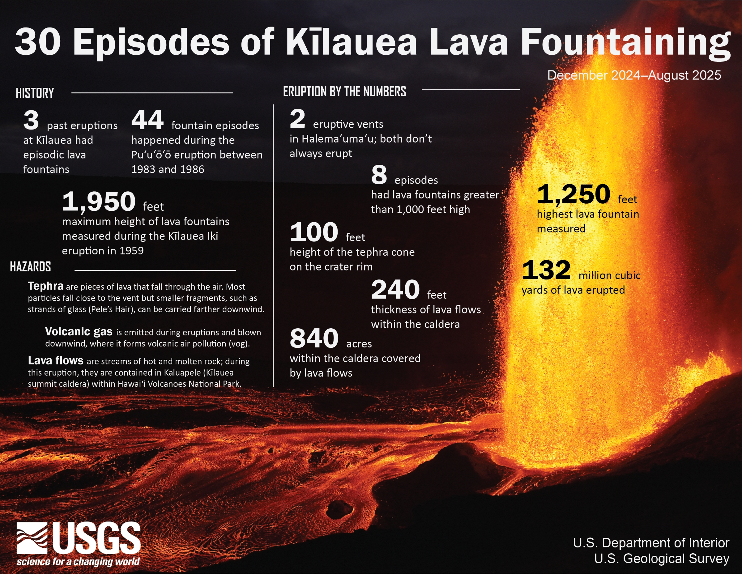
Kīlauea has been erupting episodically within the summit caldera since Dec. 23, 2024. Episode 30 of the ongoing eruption within in Halemaʻumaʻu Crater — and confined inside Hawai‘i Volcanoes National Park — happened Aug. 6.
Sulfur dioxide emission rates are elevated in the summit region during active eruption episodes. No unusual activity has been noted along Kīlauea’s East Rift Zone or Southwest Rift Zone.
WHAT’S NEXT? Summit region inflation since the end of episode 30, along with low-level tremor, suggests another episode is possible.
MAUNA LOA volcano, Hawai‘i Island
U.S. Geological Survey Volcano Alert Level: Normal
Mauna Loa is not erupting.
Hawaiian Volcano Observatory continues to closely monitor Kīlauea and Mauna Loa.
EARTHQUAKE report
There was one earthquake reported felt in the Hawaiian Islands during the past week:
- MAGNITUDE-3.2 at 3:43 a.m. Aug. 6 located 1 mile south of Pāhala in Kaʻū on Hawai‘i Island at a depth of 19 miles.
Visit Hawaiian Volcano Observatory’s website for past “Volcano Watch” articles, Kīlauea and Mauna Loa updates, volcano photos, maps, recent earthquake information and more. Email questions to askHVO@usgs.gov.
Sponsored Content
