

For the Central Pacific Basin, forecasters expect near to below average tropical cyclone activity during the 2025 hurricane season.
This is because of near normal sea temperatures along the equator coupled with typical to weaker than normal wind shear across the basin.

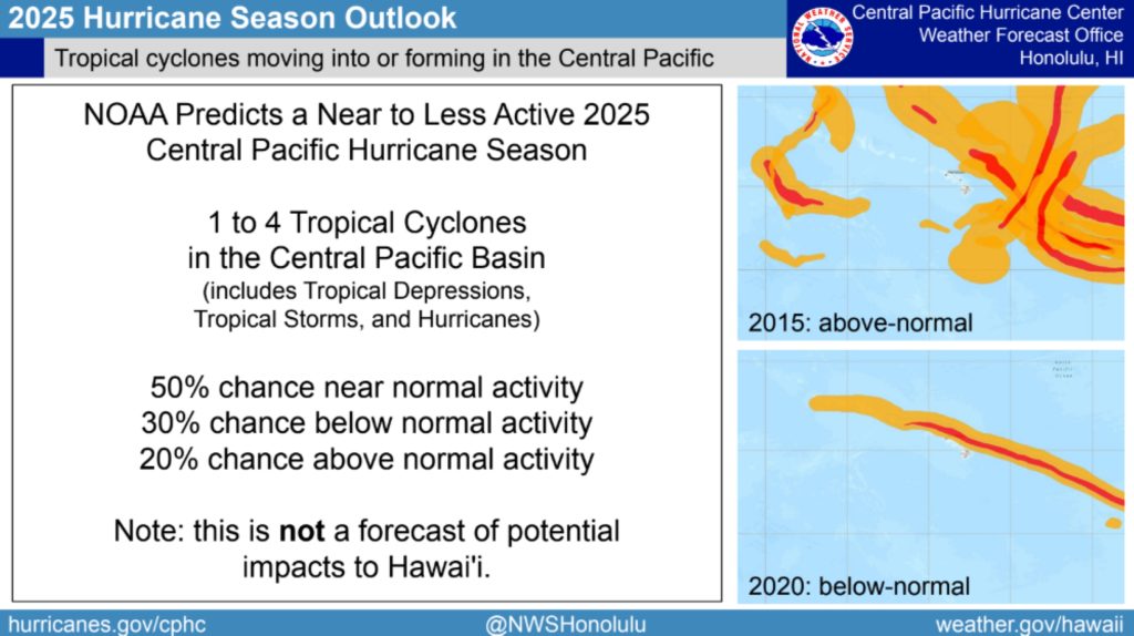
“So the outlook, specifically, is for 1 to 4 tropical cyclones, and that includes tropical depressions, tropical storms and hurricanes,” said Chris Brenchley, director of the National Oceanic and Atmospheric Administration Central Pacific Hurricane Center.
A near normal season typically has 4 or 5 tropical cyclones.
While speaking Thursday morning during a news conference at University of Hawaiʻi at Mānoa, Brenchley was adamant the seasonal outlook does not predict whether any of those cyclones will directly impact Hawaiʻi.
A further breakdown of the seasonal forecast for the 2025 hurricane season — which runs from June 1 through Nov. 30 in the Central Pacific — shows:
- A 30% chance of below normal tropical cyclone activity.
- A 50% chance of a near normal hurricane season.
- A 20% chance of above normal activity in the basin.
Brenchley explained the annual outlook is developed and coordinated by experts at NOAA’s National Weather Service Climate Prediction Center.
The center’s meteorologists analyze long-term global weather and water circulation patterns to make their outlook forecasts. The improving and increasingly accurate long-range models show where water will be warmer and upper air currents might favor hurricane development.
With El Niño conditions across the tropical Pacific stuck in neutral, meaning ocean temperatures are forecast to be near normal through summer, the warm waters that tropical cyclones need to form and feed on will exist, but nothing out of the ordinary.
That will keep waters to the east of Hawai‘i cooler, as usual, cutting off any additional energy source for storms that move close.
Typical wind shear patterns — a change in wind speed or direction because of plenty of prevailing northeast trade winds at the surface and southwest winds aloft — also will help eat away at any tropical cyclones that get close enough to threaten the islands, destroying them from above.
However, with a chance of weaker than normal wind shear forecast in the outlook, that could be an issue if a tropical system moves into the area at the right time.
“So there’s a balancing act,” Brenchley said about the circumstances that can lead to a tropical cyclone impacting the state.
Of some 72 tropical cyclones — including hurricanes and tropical storms — that have impacted the islands since the mid-20th century, Hawai‘i’s record is about only 12 of them making landfall.
The number does seem somewhat manini compared to the sheer volume of tropical cyclones that bombard the U.S. Eastern Seaboard and Gulf Coast each year, but it is still nearly 20% in the landfall column — or almost a 1 in 5 chance.
 Graphic Courtesy: National Oceanic and Atmospheric Administration Central Pacific Hurricane Center
- Graphic Courtesy: National Oceanic and Atmospheric Administration Central Pacific Hurricane Center
- Graphic Courtesy: National Oceanic and Atmospheric Administration Central Pacific Hurricane Center
- Graphic Courtesy: National Oceanic and Atmospheric Administration Central Pacific Hurricane Center


So despite the 11,000-square-mile Aloha State’s “small target in a big ocean” defense along with several atmospheric conditions and topographic features that can make it more difficult, it’s still a very real possibility each year a tropical cyclone can strike the islands head-on.
Hawaiʻi Gov. Josh Green proclaimed May 18-24 as Hurricane Preparedness Week in Hawai‘i, asking the residents of the state to be aware, educated and ready to take action to safeguard their ‘ohana, homes and businesses before hurricane season starts.
“Hawaiʻi and it’s kamaʻāina must always be vigilant to these weather events … and ready to take action when storms develop in the Pacific Ocean,” said Don ʻAweau, executive officer of the Hawai‘i Emergency Management Agency, as he he presented the governor’s proclamation during Thursday’s news conference. “It only takes one storm to change your life, your family, your ‘ohana and your community.”
Not all tropical cyclones become hurricanes, but they all have the potential.
Brenchley reiterated that even during seasons when the outlook calls for below normal tropical cyclone activity, storms that do develop can impact the islands.
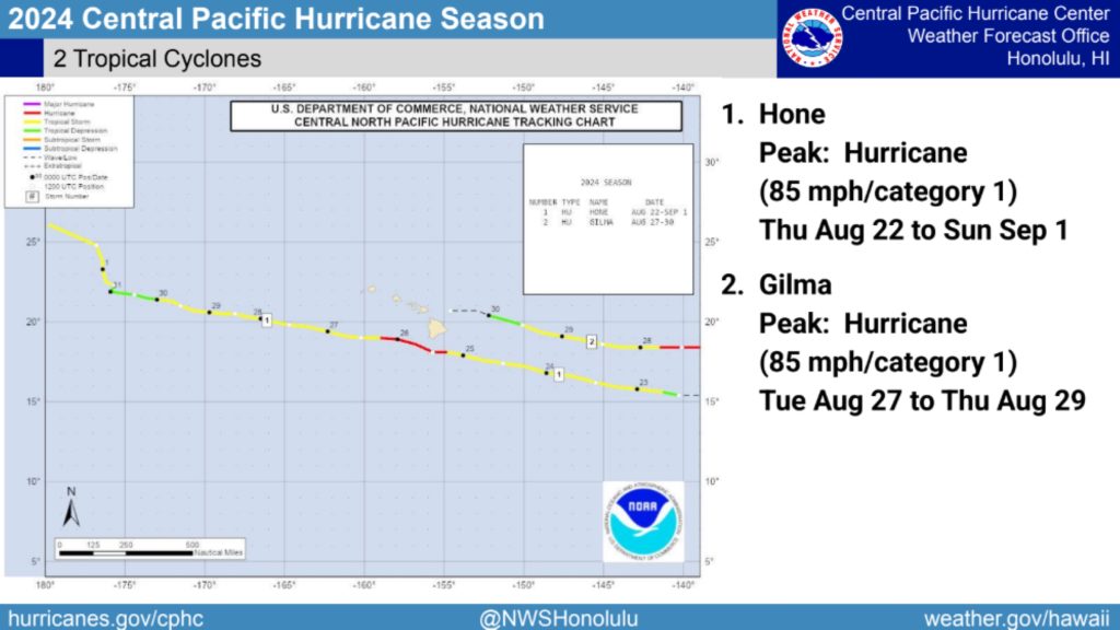
Last year is one example, with just 2 tropical cyclones moving through the Central Pacific; however, one of them was Hurricane Hone, which made its closest approach to the state as a Category 1 storm just more than 50 miles south-southeast of Ka Lae, the southermost tip of the Big Island.
Hawaiʻi County took the brunt of Hone’s wrath from Aug. 24 to 26 as it skirted to the south of the island, causing several millions of dollars in damages from flooding, high winds and power outages.
Then there have been other hurricane seasons, such as 2015, when the Central Pacific was littered with tropical cyclones and none impacted the Aloha State.

Brenchley said anytime there is a tropical cyclone in the Central Pacific, the staff at the Central Pacific Hurricane Center and National Weather Service in Honolulu will be watching closely.
Now, he added, is the time to prepare.
“All of us as residents play a role, as well as businesses, in preparing for whatever the hurricane season may bring us this year,” Brenchley said. “Know where you can get the latest official information and have a plan.”
