

“Volcano Watch” is a weekly article and activity update written by U.S. Geological Survey Hawaiian Volcano Observatory scientists and affiliates.
When magma moves into the rift zone of a Hawaiian volcano, there is understandably a lot of excitement and apprehension.
How far will the magma go? Will it erupt?
But even long after the activity stops — regardless of whether it erupts — the subsurface magma continues to have a noticeable impact on the landscape.
Hawaiian volcanoes are rightly famous for eruptions along their rift zones — geologic structures undergoing extension and through which magma can move over great distances.
Kīlauea and Mauna Loa each have two major rift zones that radiate away from their summits, and rift zone eruptions are common.

Mauna Loa’s 2022 eruption, Kīlauea’s 1983 to 2018 Puʻuʻōʻo eruption and Kīlauea’s 2018 AhuʻAilā’au eruption each occurred from rift zones.
Magma moves through Hawaiian rift zones as dikes, which are tabular sheets of magma that move laterally and vertically beneath the ground. When a dike reaches the surface, it often erupts as a linear curtain of lava, as several recent eruptions on Hawaiʻi Island demonstrated.
As dikes form in a rift zone, they wedge the zone apart, creating lots of surface displacement.
Sometimes, the amount of horizontal and vertical deformation that occurs in the vicinity of a dike intrusion can exceed several feet.
Once the dike stalls and any eruption (if one occurred) ends, one might think that is the end of the story.
Not so. The signs of magma beneath the surface can be detected for years thereafter.
One rather obvious sign of recently active magma below the ground is thermal energy. Where a dike reached shallow levels, the ground will remain hot.
Vapor emissions are common in those areas because rainwater that circulates below ground is warmed by the still-hot rock and rises to the surface as steam.
The ground can also continue to deform long after dike activity ends.
As magma cools, it solidifies and continues to drop in temperature. During this process, it contracts, or shrinks, like most materials (except water). Because magma underground cools very slowly (it is very well insulated down there), it can take years to decades, and perhaps even centuries, before reaching background temperatures.
Thermal contraction is fastest during the initial, most rapid phases of cooling, and that is reflected in the way the surface responds.
As magma cools and contracts, the ground above the shallow parts of a dike subsides, or sinks. This deformation is especially easy to see by comparing satellite radar images through time — a technique known as interferometric synthetic aperture radar, or InSAR.
The subsidence looks like a linear streak that occurs directly above the dike in InSAR data. In that sense, using InSAR to map subsidence after a dike intrusion can help geologists understand where exactly a dike is located, how much magma is in the dike and how quickly it is cooling.
The linear pattern of subsidence seen in InSAR images is apparent after nearly all dike intrusions at Hawaiian volcanoes.
For example, subsidence occurred for a few years above the so-called “Fathers Day” dike that intruded between Maunaulu and Makaopuhi Crater in June 2007, feeding a very small eruption on Kānenuiohamo.
Subsidence also marks the lower East Rift Zone of Kīlauea above the trace of the dike that erupted in 2018.
Streaks of subsidence are likewise apparent above the dikes that erupted from Mauna Loa’s Northeast Rift Zone in 2022 and from Kīlauea’s Southwest Rift Zone in 2024.
There is obviously a lot to measure when magma moves through the rift zones of Hawaiian volcanoes, and it is a time of special vigilance, given how many residents live on the flanks of our active volcanoes.
But the action doesn’t stop just because the eruption or intrusion ends.
There’s still much that can be learned about the characteristics of magma within Hawaiian rift zones from mapping deformation patterns after the magma stops moving!
Volcano Activity Updates
Kīlauea has been erupting episodically within Kaluapele, the summit caldera, since Dec. 23, 2024. Its U.S. Geological Survey Volcano Alert Level remains at Watch.
The eruption in Halemaʻumaʻu Crater continued during the past week with Episode 15.
Low-level spatter fountains and lava flows marked the start of the most recent eruptive episode of the summit eruption just after noon March 25.
High lava fountaining commenced at about 10:20 a.m. March 26, continuing for about the next 9 hours and producing lava geysers more than 1,000 feet tall, the largest so far since the this eruption began and some of the tallest erupted by the volcano in at least the past 40 years since the first 3 years of the Pu’u’ō’ō eruption from 1983-86.
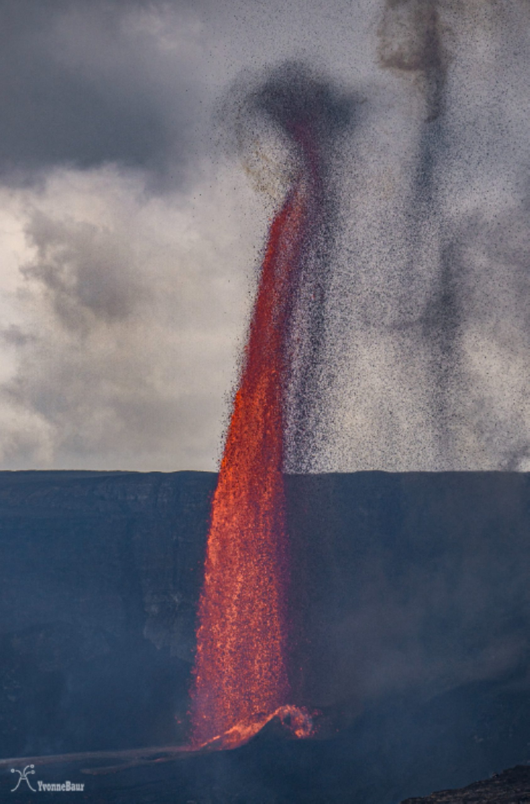
Kīlauea’s summit region has been inflating again since Episode 15 ended at 7:10 p.m. March 26, after 31 hours and 6 minutes of erupting, the longest active phase of the eruption since Episode 4, which lasted 3 days, 1 hour and 10 minutes.
Hawaiian Volcano Observatory data from the morning of March 27 showed that during the few hours following the end of Episode 15, about a dozen small seismic events occurred near the summit; following those events, variably weak seismic tremor returned.
Tiltmeters at two different locations in the volcano’s summit region had each recorded about 2 microradians of inflation by almost 10:30 a.m. Thursday as well, suggesting another eruptive episode is possible.
Sulfur dioxide emission rates are elevated in the summit region during active eruption episodes. No unusual activity has been noted along Kīlauea’s East Rift Zone or Southwest Rift Zone.
Mauna Loa is not erupting. Its U.S. Geological Survey Volcano Alert Level remains at Normal.
Two earthquakes were reported felt in the Hawaiian Islands during the past week:
- MAGNITUDE-3 located 7 miles northeast of Pāhala at a depth of 19 miles at 3:37 a.m. March 26.
- MAGNITUDE-3.2 located 19 miles west-southwest of Kailua-Kona at a depth of 18 mi at 2:36 p.m. March 25.
Hawaiian Volcano Observatory continues to closely monitor Kīlauea and Mauna Loa.
Visit the volcano observatory website for past “Volcano Watch” articles, Kīlauea and Mauna Loa updates, volcano photos, maps, recent earthquake information and more.
Email questions to askHVO@usgs.gov.
