

Unsettled weather expected; surf advisory begins later today for north, west shores
This story was updated at 8:18 a.m. Feb. 17.
A cold front more than 200 miles northwest of Kaua‘i was slowly approaching the islands Sunday night, causing showers to develop over Kaua‘i and Ni‘ihau.

That front is expected to stall out today before eventually dissipating near Kaua‘i, bringing additional unsettled wet weather — including a chance for isolated thunderstorms and possibility of localized flooding — to both islands.
A high surf advisory also goes into effect later today with the arrival of a new large northwest swell.
Rainfall was already heavy early this morning.
The National Weather Service issued a flood advisory until 8:30 a.m. today for the entire Garden Isle because of a threat of flooding from excessive rainfall on roads and in poor drainage areas and streams.
Heavy rainfall started moving over Kaua‘i by about 4:30 a.m., with rain falling at 1 to 2 inches an hour over the entire island.
The flood advisory was canceled at about 8:15 a.m. after radar showed heavy rain had diminished as the cold front continues to move east and flooding was no longer expected at the time.
National Weather Service satellite and local radar imagery Sunday night just before 9 p.m. showed a band of clouds and embedded showers streaming up from the south over Kaua‘i and Ni‘ihau.
Rainfall amounts from 0.10 to 0.50 of an inch were expected overnight into this morning for portions of the Garden Isle before the cloud band drifts slowly eastward as the cold front approaches from the northwest.
The area forecast discussion said a wet weather trend will continue through today.
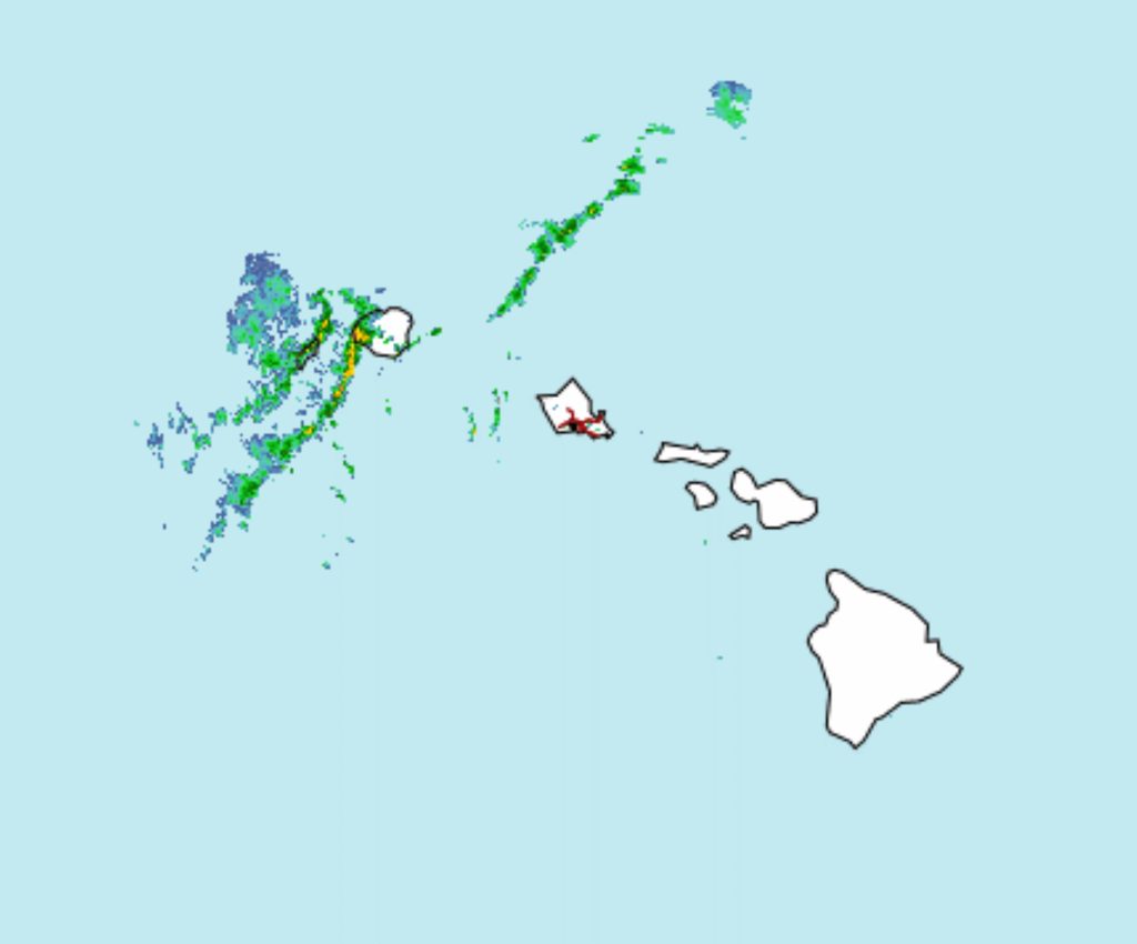
 National Weather Service radar image from early Monday morning, Feb. 17, 2025.
- National Weather Service radar animation from early Monday morning, Feb. 17, 2025.


Forecast models show the frontal band slowing down and stalling near Kaua‘i by tonight.
Shower bands moving up from the south have the potential to produce localized flooding in some areas where they can line up and train over island mountains, with an elevated threat over the Garden Isle and Ni‘ihau.
There also is a chance for isolated thunderstorms over both islands as the front moves over the western half of the state.
The main band of moisture should begin to diminish by this afternoon as the frontal band dissipates and more stable air moves in from the east.
Enhanced shower activity will rapidly diminish from Monday night into Tuesday.
A high surf advisory is in effect from noon today through 6 p.m. Tuesday for north and west shores of Kaua‘i and Ni‘ihau as a large northwest swell builds surf to advisory levels by this afternoon.
Surf of 12 to 20 feet is forecast along northern shorelines and 9 to 16 feet for western coasts, causing strong breaking waves and strong currents that will make swimming and likely other ocean activities dangerous.
Forecasters urge members of the public who will be on or near the impacted shorelines to heed all advice from ocean safety officials — when in doubt, don’t go out.
National Weather Service forecasters in Honolulu say more stable easterly trade winds will return Tuesday to the state, with periods of windward and mountain showers through Wednesday night.

A strong ridge aloft builds in Thursday, producing dry and stable conditions through the rest of the week and upcoming weekend.
Lighter winds are forecast from Friday onward, however, as another shallow cold front approaches the state from the northwest.
Visit the National Weather Service Honolulu forecast office website for additional and updated weather forecasts and information.
Sponsored Content
