

UPDATE: Officials advise public to prepare for possible impacts of Tropical Storm Calvin
Updated story at 12:34 p.m. on July 16: As Tropical Storm Calvin continues its track toward the Hawaiian Islands, Kaua‘i County officials are reminding residents and visitors to get prepared and stay informed.
“While it’s still too early to know what impacts Calvin will have here on Kaua‘i, now is the time to start preparing,” said Mayor Derek S.K. Kawakami in a press release. “Weather forecasts are very helpful, but can change quickly. It’s important to remain vigilant and informed on updates as they develop.”
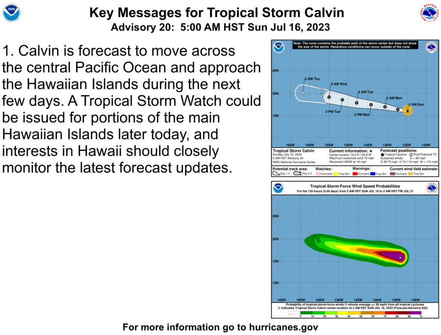
According to the National Weather Service, Calvin is expected to enter the central Pacific basin late Sunday night and weaken as it approaches the state on Tuesday into early Wednesday. Kaua‘i County could feel effects of the storm by Wednesday afternoon, but forecast uncertainty remains high at this time.
Officials recommend that residents and visitors take the following precautions when preparing for a weather emergency:
- Emergency Preparedness Kits – Emergency preparedness kits should contain at least a 14-day supply of food and water (to include non-perishable food and one gallon of water per person per day). Kits should also include a battery powered radio, flashlight, an extra supply of prescription medicines and other items specific to individual and family needs. It is also recommended that face coverings and hand sanitizer also be included in your kits. Set aside an emergency supply of any needed medication and keep a copy of your prescriptions in case you run out of medication after a disaster.
- Check Your Property – Walk your property, checking for small outdoor items that could be picked up by high winds, and check for potential flood threats. If time and conditions permit, clear your gutters and other drainage systems.
- Make an Action Plan – Discuss with family members what you plan to do if a hurricane or tropical storm threatens. Make an action plan, which should include details such as whether your family will shelter in place or evacuate to a shelter. There are no plans to open shelters at this time; however, the county will work with the American Red Cross to open shelters on an as-needed basis and will announce a list of open shelters if or when they become available.
- Outdoor activities – Visitors and residents are urged to check conditions before venturing out for any hiking, river or beach excursions. Do not cross swollen rivers or streams, and always check with a lifeguard at any lifeguard station before entering the ocean. Know before you go. For up-to-date information about Kaua‘i ocean conditions and ocean safety, please speak to a county lifeguard, visit www.hawaiibeachsafety.com, or call the Ocean Safety Bureau at 808-241-4984.
- Kaua‘i Island Utility Cooperative – Please visit http://website.kiuc.coop/ to learn more about how to prepare for a power outage.
- Kekaha landfill and refuse transfer stations – The Kekaha landfill and county refuse transfer stations may close due to severe and inclement weather. For more information, visit kauai.gov/solidwaste or call 808-241-4841.
- Kaua‘i Department of Water – Severe weather storms can cause damage to water systems, disrupt electrical power to DOW pumps and equipment, block road access to water sources, and may impact water quality. Customers should prepare for emergency water service disruptions by having the recommended water storage supply readily available for essential uses. For more water emergency preparedness tips, please visit www.kauaiwater.org.
- Stay Tuned – Continue to stay tuned to local media broadcast channels for the most up-to-date information. The following provides a list of important resources on emergency preparedness.
- Kaua‘i Emergency Management Agency – kauai.gov/kema
- National Weather Service – weather.gov/hfo, or automated weather line at 808-245-6001
- To sign up for Wireless Emergency Notification System (WENS), the county’s emergency notification service, please go to the county’s website, www.kauai.govand click on “Emergency Notifications.” You may also call the Kaua‘i Emergency Management Agency at 808-241-1800.
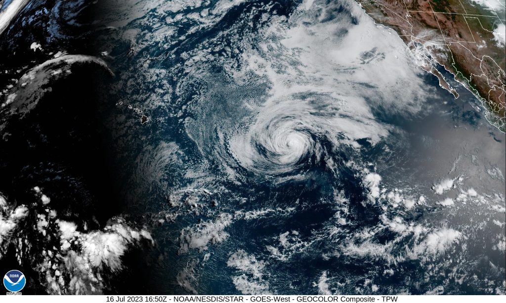
Original story at 11 a.m. on July 16: Calvin is now a tropical storm with sustained winds of 70 mph as it continues on a west northwest path at 16 mph, located 1,360 miles east southeast of Hilo.
The National Weather Service said the center of Tropical Storm Calvin is expected to move “close to, or over, the islands” from Tuesday night through Wednesday night.
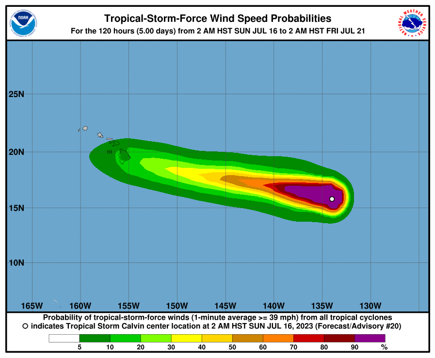
The forecast from the National Hurricane Center has consistently anticipated “tropical-storm-force winds in its northern semicircle” during its transit. They currently extend outward up to 105 miles from the center of the system.
The storm potentially will bring a period of locally strong winds, heavy rain and high surf.
“Some uncertainty continues to exist with respect to the track and intensity forecast, and it is also important to remember that impactful weather can occur well away from the center,” the National Weather Service advised in its latest forecast.

“Calvin’s forward speed will be fairly quick when it is near the islands (toward the west at about 19 mph), so the amount of time any one island experiences gusty winds and heavy rainfall will be somewhat limited (probably on the order of 12-18 hours). However, the potential for extreme rainfall rates will likely warrant the issuance of a Flood Watch, which is usually done with about a 48 hour lead time,” according to the National Weather Service.
Based on the timeline, portions of the state could see watches issued later Sunday.
The latest National Hurricane Center forecast notes that swells generated by Calvin are expected to begin reaching the Hawaiian Islands during the next couple of days.
The National Weather Service is forecasting a return to a “typical trade wind weather pattern” from Thursday into next weekend as the remnants of Calvin move quickly west away from the islands, “likely as a trough.”
The National Hurricane Center reports that Calvin is expected to continue weakening during the next few days.
Sponsored Content
