Volcano Watch: Scientists reflect on destructive 2018 eruption of Kīlauea on Big Island

Five years ago, volcanic activity at Kīlauea on the Big Island dramatically changed when magma intruded into the lower East Rift Zone. What happened at Kīlauea in 2018? What have been the resulting learning opportunities?
The events in 2018 ended the 35-year-long Pu‘u‘ō‘ō eruption (on the middle East Rift Zone), along with the 10-year summit eruption. The summit lava lake drained, as did some of the shallow magma stored beneath the summit, which in turn triggered collapse and gradual caving of the summit caldera floor.
The sequence of events began on April 30, 2018, when Pu‘u‘ō‘ō crater floor collapsed as magma began intruding downrift. Over the next several days seismic and deformation data tracked the dike as it migrated underground farther down the East Rift Zone.
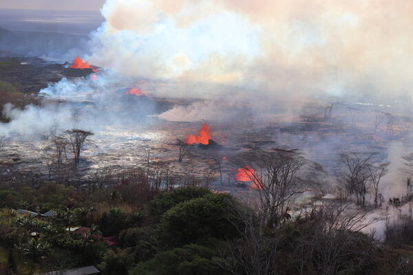
The first lower East Rift Zone eruption in 58 years began on the evening of May 3 when a fissure opened in the Leilani Estates subdivision. By the end of May 4, six fissures had opened in the lower East Rift Zone and a magnitude-6.9 earthquake struck the south coast of the Big Island.
The summit lava lake level began to drop as magma moved into the lower East Rift Zone, and sections of the unsupported crater walls fell into the lake, triggering small explosive events. Hawai‘i Volcanoes National Park closed to the public on May 11, and Hawaiian Volcano Observatory staff vacated the office on Uēkahuna bluff on May 16 due to increased ash explosions, seismic activity and building damage.

From early May to late August, observatory staff — with help from the U.S. Geological Survey’s Volcano Science Center, the University of Hawai‘i and other Department of the Interior offices — maintained a 24-hour field presence and data watch to monitor the eruption and communicate any changes to the public and emergency managers.
These collaborations were essential for continuous monitoring and data analysis, but they also introduced new monitoring techniques like using Unoccupied Aircraft Systems, which are now included as part of the observatory’s routine eruption monitoring tasks.
The 2018 eruption was the most destructive over the past 200 years in Hawai‘i, with 24 fissures covering an area of over 8,700 acres, including the addition of 875 acres of new land beyond the old coastline.
More than 700 structures and 30 miles of roads were covered, displacing many residents. Gas emissions were at the highest levels ever recorded at Kīlauea and impacted much of the State of Hawaiʻi and areas as far away as Guam.
The summit region experienced 62 total collapse events during the eruption. These near-daily occurrences each released energy roughly equivalent to a magnitude-5.3 earthquake. Shaking from these events caused damage to nearby homes and businesses, along with Hawai‘i Volcanoes National Park roads and infrastructure, and the former Hawaiian Volcano Observatory building. Volcanic ashfall from explosions in May, and gas emissions, also impacted downwind communities in the District of Kaʻū.
Recovery efforts are still underway for Big Island communities impacted by the 2018 eruption, and for the observatory.
The Additional Supplemental Appropriations for Disaster Relief Act of 2019 (H.R. 2157) has provided new opportunities for the observatory to bolster monitoring and eruption response abilities and is supporting research that will help us to better understand Hawaiian volcanoes.
Some of the observatory’s new monitoring capabilities include cutting edge field equipment for tracking seismicity, ground deformation, gas, gravity, lava lake levels and surface changes. Lab equipment that can analyze physical and chemical characteristics of ash and cinder and lava samples, providing insights on eruptive processes, has also been acquired due to the supplemental funding.
Exciting new research has also been taking place at Kīlauea to help improve our understanding of the volcano’s magma plumbing system and structure, eruptive past and hazards. This includes the ongoing Kīlauea Seismic Imaging Project.
In the years since 2018, the observatory has had the opportunity to apply lessons learned during 2018 to several Kīlauea summit eruptions and the first Mauna Loa eruption in 38 years. Research and monitoring upgrades funded through the supplemental funding have advanced our understanding of Hawaiian volcanoes, helping us to learn more about their hazards and potential future eruption impacts.
Editor’s Note: Volcano Watch is a weekly article and activity update written by scientists and affiliates with the U.S. Geological Survey’s Hawaiian Volcano Observatory.


