

Where is magma stored beneath the surface of Kīlauea and how is it transported to the places where eruptions occur?
Scientists have hypothesized the shape and size of Kīlauea’s summit magma storage system for the last century, and now have an unparalleled opportunity to develop a far more detailed picture than was possible before.
The collaborative Kīlauea Seismic Imaging Project is about to start with a goal to help reveal subsurface structures beneath Kīlauea’s summit region. The research project is funded by the National Science Foundation and the U.S. Geological Survey’s appropriations from the Disaster Relief Act of 2019, which was provided in response to Kīlauea’s 2018 lower East Rift Zone eruption and summit collapse.
The project will operate almost like a human CT scan, during which a body enters a tube so that X-rays can travel through the body at different angles. From the X-rays, cross-sectional images are created of the features within the body, which are used collectively to make a three-dimensional model of the body.
During the Kīlauea summit imaging project, seismic waves moving through the ground will be used to generate images of the subsurface that together will create a three-dimensional model of Kīlauea’s summit magma storage geometry.

Hawaiian Volcano Observatory has a permanent monitoring network of several seismometers at the summit of Kīlauea that detect natural earthquakes, but more seismometers are needed to collect data at a higher resolution for this project. An additional 1,800 small earthquake-detecting devices, called seismic nodes, will be temporarily placed on the surface of Kīlauea’s summit region in the next two months.
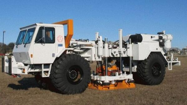
After the seismic nodes, which will blend into the natural landscape, are deployed, a large vehicle will slowly traverse roads near Kīlauea’s summit in May. The vehicle, called a Vibroseis, will create tiny seismic signals. The Vibroseis is operated by engineers and field crews from the Natural Hazards Engineering Research Infrastructure experimental facility at the University of Texas at Austin, which is supported by the National Science Foundation.
The nodes will capture the signals generated by the Vibroseis. The time that it takes the signals to reach the nodes and the way they change before reaching the nodes are important because seismic waves behave differently if the material they are traveling through is solid rock, semi-solid mushy material or molten magma.
The vast amounts of data collected will be analyzed to outline where the base of Kīlauea contacts the underlying ocean floor, the location of major faults and fault blocks, where bodies of magma are stored beneath the surface of Kīlauea, and how those bodies connect to the rift zones.
The data also will produce a new velocity model for Kīlauea’s summit region. Velocity models describe how fast earthquake waves move through subsurface regions and the model will allow for more accurate analyses of earthquakes and their locations in the future.
During April through June, you might see USGS scientists deploying or retrieving these seismic nodes across the summit of Kīlauea volcano. Most of the work will be done from the ground, although there will be several days of helicopter-supported work.

The Vibroseis vehicle will move slowly on roads in the region, including roads within Hawai‘i Volcanoes National Park, portions of Highway 11 near Kīlauea summit, and segments of Wright Road and Haunani Road in Volcano Village. Unless you are close to the Vibroseis, you will not be able to feel the tiny vibrations or hear the whining noise the vehicle makes as it operates.
Results from this research project will be invaluable for assessing the ever-evolving hazards and future volcanic activity at Kīlauea. The work is being conducted under a research permit from Hawai‘i Volcanoes National Park and with permission from the State of Hawaiʻi Department of Transportation and Hawaiʻi County’s Department of Public Works.
If you have any questions about the project, email askHVO@usgs.gov. More details and updates on the progress of the Kīlauea subsurface imaging project can be found here: https://www.usgs.gov/supplemental-appropriations-for-disaster-recovery-activities/science/2019-kilauea-disaster-2.
Volcano Watch is a weekly article and activity update written by scientists and affiliates with the U.S. Geological Survey Hawaiian Volcano Observatory.
