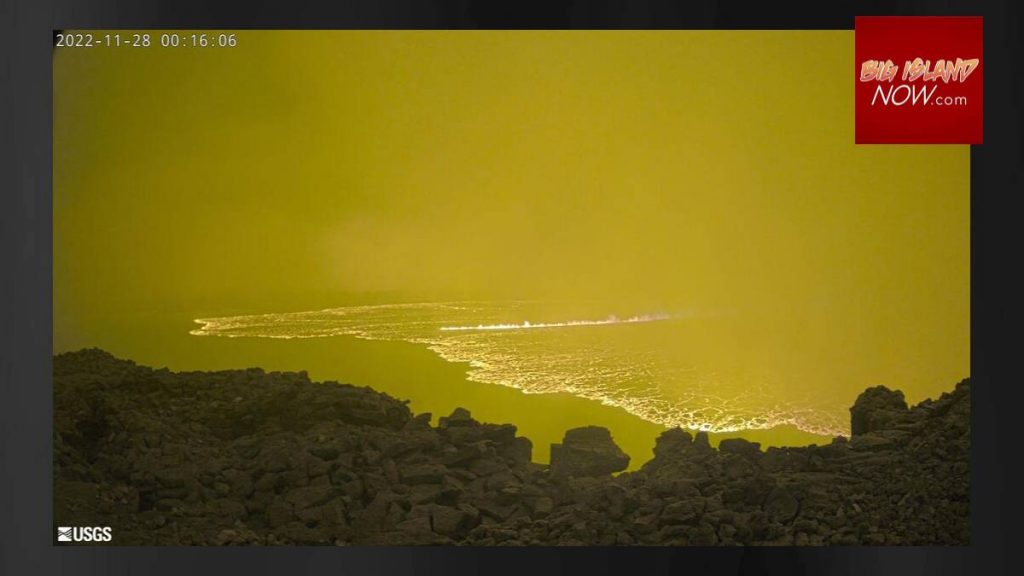
Mauna Loa UPDATE: Lava flowing down northeast flank; no immediate threat to communities
UPDATE 7:20 a.m. Nov. 28: Hawaiian Volcano Observatory confirms that lava has exited Mauna Loa summit and can be seen on the northeast flank. At this time, the lava is not flowing toward populated areas and does not pose a threat to any communities.
The National Weather Service has issued an Ashfall Advisory for all districts of Hawaiʻi Island through today. Trace amounts of ashfall and volcanic gas is expected. People with respiratory illness should remain indoors. If you must go outdoors, use face coverings to prevent inhaling ash particles.
ORIGINAL POST: Mauna Loa, the 13,681-foot volcano on the Big Island, is erupting for the first time in 38 years.
The eruption began about 11:30 p.m. Sunday in Moku‘āweoweo, the summit caldera of Mauna Loa, inside Hawai‘i Volcanoes National Park.
A half-hour earlier, the National Weather Service reported a 4.4 magnitude earthquake occurred in the summit area of Mauna Loa.
At the time the eruption began, scientists with the Hawaiian Volcano Observatory said lava flows are contained within the summit area and are not threatening downslope communities.
While lava flows in the summit region are visible from Kona, a 2:45 a.m. update from the observatory said all vents remain restricted to the summit area. There is currently no indication of any migration of the eruption into a rift zone.
The National Weather Service issued an ashfall advisory until 6 a.m. Monday morning. Up to one-quarter inch of ashfall accumulation is forecast for a portion of the Big Island.
“Winds may carry volcanic gas and possibly fine ash and Pele’s hair downwind,” said a news release from the observatory.

It could cause possible harm to crops and animals and reduce visibility. People with respiratory illnesses should remain indoors to avoid inhaling the ash particles and anyone outside should cover their mouth and nose with a mask or cloth.
The Hawai‘i Emergency Management Agency has activated its Emergency Operations Center for enhanced monitoring of the evolving situation and to provide any support requested. At this time, no evacuation has been ordered.
Residents living on Mauna Loa slopes should review their preparedness. For preparedness information from Hawai‘i County, see these resources: https://hawaii-county-volcano-hazards-hawaiicountygis.hub.arcgis.com/.
As a precaution, shelters have been opened at Old Kona Airport in Kailua-Kona and Kaʻu Gymnasium in Pāhala.
Facebook video posts from residents on the Big Island showed the glow of the eruption, while birds chirped in the background.
“It’s nut. Look at that. It’s worth getting out of bed. … ” said Shantell Walker Otare who could see the eruption from Kona. “You can see plume of smoke that came up from the original eruption. … Spectacular spectacle. The type of views you see on an island that is alive.”
“Pretty damn scary,” said Tom Grice on his Facebook post. “We’re watching it pretty carefully.”
“That’s the volcano. Holy Cow,” said another Facebook poster.
The Hawai’i Police Department has closed the Mauna Loa Access Road at the intersection with Daniel K. Inouye Highway due to the eruption.

Mauna Loa was long overdue to erupt. The volcano had erupted 33 times since 1843, but the last time had been March 25, 1984.
Scientists had been closely monitoring the volcano, which has had increased seismic activity for the past few months. The Mauna Loa summit, cabins and high-elevation areas have been closed for weeks due to the increased seismic activity.
Community meetings have been held around the Big Island by the Hawai‘i County Civil Defense and the Hawaiian Volcano Observatory to answer questions and provide information due to the heightened unrest.
On Sunday, a 4.1 magnitude earthquake also occurred on the summit region of Mauna Loa volcano at 11:52 p.m., according to the National Weather Service in Honolulu.
Based on past events, the early stages of a Mauna Loa eruption can be very dynamic and the location and advance of lava flows can change rapidly.
If the eruption remains in Moku‘āweoweo (the summit caldera), lava flows will most likely be confined within the caldera walls. However, if the eruptive vents migrate outside its walls, lava flows may move rapidly downslope.
When Mauna Loa erupted in 1950 in the Southwest Rift Zone, lava made it to the ocean within three hours.
People living on the Mauna Loa slopes should stay informed through HCCDA alerts and take steps to prepare in the event action is needed. For preparedness information from Hawai‘i County, see these resources: https://hawaii-county-volcano-hazards-hawaiicountygis.hub.arcgis.com/
The Hawaiian Volcano Observatory is in close consultation with emergency management partners and will be monitoring the volcano closely to provide further updates on activity. The observatory said it will conduct aerial reconnaissance as soon as possible to better describe the eruption and assess hazards.
For more information, click here.
Mauna Loa webcams are at https://www.usgs.gov/volcanoes/mauna-loa/webcams.


