

With all the recent seismic activity happening underneath Mauna Loa’s 13,679-foot summit — including 5.0 and 4.6 earthquakes that shook the island 24 seconds apart on Oct. 14 — some people on the Big Island fear that the “sleeping giant” is ready to erupt.
The world’s largest active volcano is overdue for lava to spew. It erupted 33 times since 1843. But the last time it did so was in 1984, the longest gap the volcano has gone without an eruption in the past two centuries.
Oceanview Estate resident Rose Karrow, who moved to the Big Island from Delaware, said the earthquakes were “nerve-wracking” and now she knows they are related to volcanic activity at Mauna Loa, which is overdue for an eruption.
“I’m not scared yet but if things get worse, I probably will be,” the 21-year-old said.
When the recent seismic activity started, Hawaiʻi County Civil Defense administrator Talmadge Magno said the agency received phone calls from some nervous residents. It also received calls from people who have become acclimated to living on a volcano and were seeking information.
To provide a seismic update, answer questions and discuss preparedness, Civil Defense and the Hawaiian Volcano Observatory will host a public information session about Mauna Loa on Oct. 22 at the Ocean View Community Center from 1 to 3 p.m.
Magno and the volcano observatory’s scientist-in-charge Ken Hon will lead the community meeting that will include what residents can do to stay safe in the event of an eruption.
This could help people like Karrow with their preparedness. She said: “We decided if worse comes to worst we’ll take our stuff and evacuate. We might not know where we’ll be going.”
Over the years, the observatory and emergency management officials have urged residents living on Mauna Loa’s slopes to have a “go bag” with essentials and important documents in case of an evacuation order.
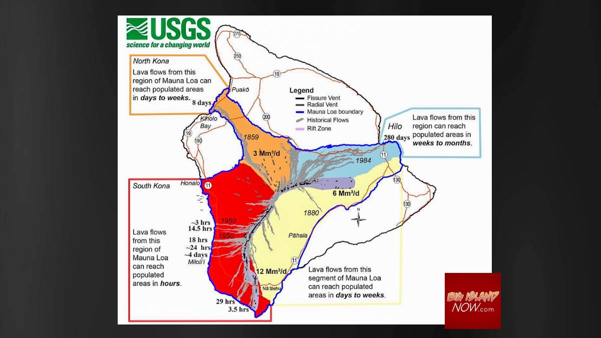
Mauna Loa is big, covering half the island. While it could take days or weeks for an eruption to threaten populated areas, it also could happen quickly. In the 1950 eruption, the Honokua lava flow on the Southwest Rift Zone made it to the ocean in less than three hours, according to the USGS.
During those three hours the lava covered the village of Hoʻokena-mauka. Fortunately, all the villagers reached safety unharmed, but two dozen structures were destroyed and the highway was cut in three places before the eruption ended 23 days later.
Hawaiian Volcano Observatory officials say Mauna Loa is in a state of “heightened unrest” that is being driven by renewed input of magma 2 to 5 miles beneath Mauna Loa’s summit that is causing earthquakes and tremors.
The USGS also stated in its most recent daily update: “The current increase in activity does not suggest that a progression to an eruption is certain, and there are no indications that an eruption is imminent.”
But USGS also says: “Mauna Loa is certain to erupt again, and with such a propensity to produce large flows.”
But when, nobody knows.
Mauna Loa used to erupt about once every 4.3 years, but this current gap of 38 years between eruptions is the longest in the past two centuries, prompting scientists to call the volcano the “sleeping giant.”

It also has led to complacency among many residents who have no recollection of the last time Mauna Loa erupted, which was April 15, 1984.
But scientists at the USGS Hawaiian Volcano Observatory were kept up the evening of Aug. 2 and into the early hours of Aug. 3 monitoring Mauna Loa when a swarm of earthquakes took place beneath Mauna Loa’s summit region. Over a period of about 10 hours, 90 earthquakes were located and many more earthquakes were detected, but were too small to precisely locate. The total number of earthquakes peaked at over 200 per hour.
And with additional recent seismic activity, Hawai‘i Volcanoes National Park decided to take precautionary action and indefinitely closed the Mauna Loa summit backcountry.
Hilo native Craig Kadooka can tell people what it is like when Mauna Loa erupts. He was living in Kaumana City the last time the volcano spewed lava. The glowing flow stopped just four miles from his house — and just 4.5 miles from Hilo, the largest population center on the island.
“We weren’t in panic but we got our important papers together and loaded them in the car just in case,” he recalled.

On Facebook, Beau Jack Key tells the harrowing story of his family escaping the lava flow from the 1984 Mauna Loa eruption when he was just 12. He remembers in great detail the “exciting but scary” car ride in the middle of the night in the familyʻs metallic blue Chevy Station Wagon.
His father told him and his siblings to grab their pillow and blankets and get in the car. About an hour later they passed near Hilo High School and hit traffic.
“As we slowly crept along we started seeing the glow and then in a clearing we could see the actual lava flow,” Key remembered. “It was so dark that the lava appeared to be closer than it really was. I will never forget that sight!!”
The Big Island’s concern — or lack of it — about a new eruption comes just four years after the 2018 eruption of nearby and smaller Kīlauea volcano, which devastated the lower Puna district. From May through August, large lava flows destroyed about 700 homes, buried subdivisions and permanently affected the lives of thousands of residents, according to the National Park Service.
People still are rebuilding their lives.

Nic Francisco, 41, was one of the thousands of Pahoa residents impacted by the lava flow. His home in Leilani Estates was destroyed. He camped with his family until he was able to rebuild his life in Orchidland with his wife and children.
The volcano not only destroyed his home, but the entire subdivision, which was built on a rift zone similar to an area in Oceanview that may be impacted if Mauna Loa erupts.
“The emotions that stir up for me is why did the county, many years ago, allow houses to be built in these rift zones in the first place?” he said. “It makes me wonder how this happens and it is unfortunate. Other people may have to go through that again, losing their homes and being displaced.”
Rift zones are areas of structural weakness within the flanks of volcanoes. Rift zones allow magma from a reservoir below the summit region to move into the flanks and rise vertically to feed an eruption or an intrusion.
Magno with the Civil Defense said unfortunately allowing people to build in a rift zone happened “a long time ago” and “even before statehood” in 1959.
He said the best emergency officials can do is educate the public about the issue.
“We found in Kīlauea some people knew what they were getting into and felt there wouldn’t be an eruption in their lifetime, and on the other end of the spectrum people were not aware,” he said.
In the past, Mauna Loa eruptions have produced large, voluminous flows of basalt that have reached the ocean eight times since 1868. Each eruption is different, as seen by maps showing where lava has flowed on Mauna Loa.
An eruption can threaten most areas on the downslope. And now, Mauna Loaʻs downslope is a lot more developed than it was in 1984. From that year until 2002, approximately $2.3 billion was invested in new construction on the flanks of the volcano, according to the USGS 2012 fact sheet. And more development has been built in this area in the last decade.
Mayor Mitch Roth has said it’s not the time to panic, but it is time for residents to be prepared.
For the Hawaii County Civil Defense volcano hazard page, click here.
For more information on Mauna Loa follow this link.
