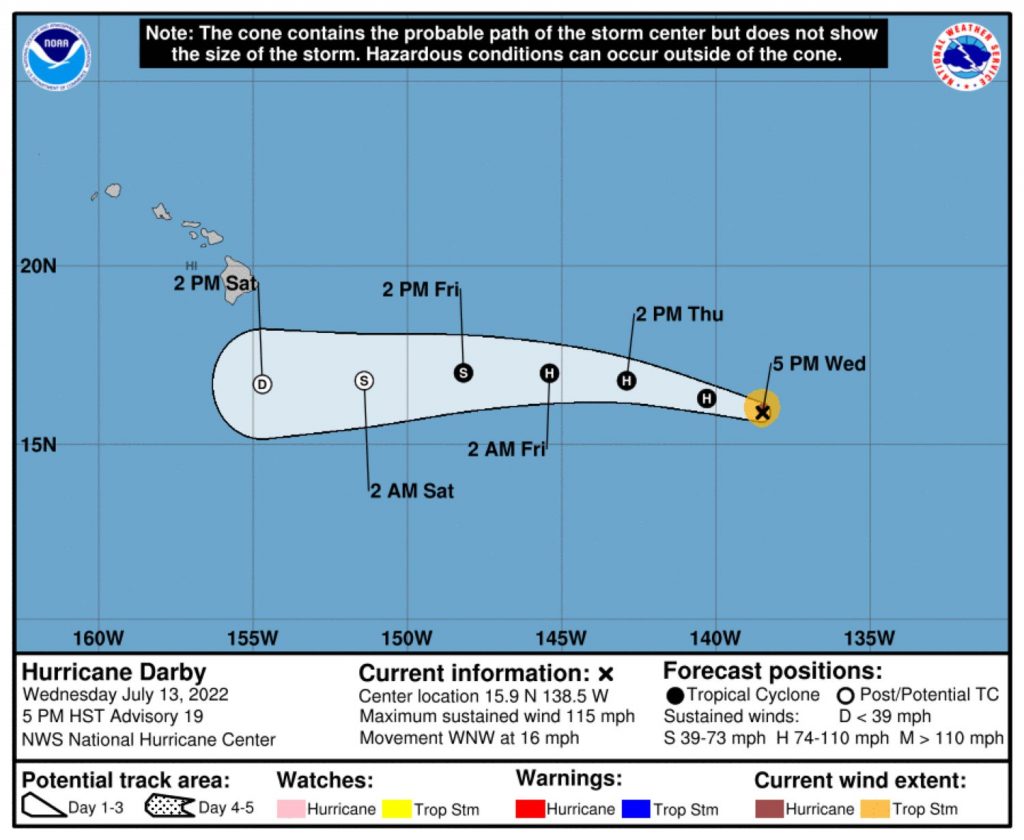
Hurricane Darby re-intensified Wednesday, July 13, but is still expected to weaken during the next few days.
The Central Pacific’s latest named tropical cyclone was about 1,120 miles east of Hilo as of 5 p.m. Wednesday, with maximum sustained winds at 115 mph, according to the Central Pacific Hurricane Center. The Category 3 hurricane was moving west-northwest at about 16 mph.
While Darby picked up some steam Wednesday, spending much of the day as a Category 2 system and then intensifying to Category 3 during the afternoon, the storm is still forecast to weaken steadily. Darby is expected to become a tropical storm in the next 24-36 hours and a post-tropical/remnant low in 72 hours.
Cooler waters near and upstream of the Hawaiian Islands will rob Darby of the energy it needs to maintain its intensity, according to meteorologist Joe Clark with the Honolulu Forecast Office of the National Weather Service and Central Pacific Hurricane Center. As the storm gets closer to the islands, dry air in the mid-levels of the atmosphere and increasing wind shear will cause further declines in intensity and organization.
The latest forecast track shows Darby staying to the south of the state and weakening to a tropical depression by Saturday, July 16. Clark said the storm will be well into a weakening phase at its closest point to the Big Island and conditions will not be conducive for intensification by then.
“Darby will not look like it does now,” Clark told Big Island Now on Wednesday morning via email. “It will not be surrounded by an intense ring of convection and it will not have an eye. It is unlikely that it will still be classified as a tropical system at all once it is south of the Big Island.”
There is a chance remnants of the storm could shift to the north — or south — but would not be likely to directly strike the Big Island.
“A minor northward or southward adjustment to the track is possible, but the remnants of Darby will not turn north and directly impact the smaller islands,” Clark said. “The focus of the forecast instead will be on heavy rain potential that will most likely be focused over the Big Island. This potential will be directly tied to subtle north/south adjustments in the forecast track.”
If the storm does track farther north than anticipated, the probability of heavy rain and potential flooding Friday night and Saturday on the Big Island would increase.
Clark said potential impacts of Darby are:
- Widespread rain Friday night through Saturday over windward areas of the Big Island. If the remnants of Darby track even slightly farther north, the potential for heavy rain will be higher. While some flooding is within the realm of possibility, he said, conditions will probably not be conducive for widespread flash flooding.
- Trade winds will strengthen in response to the remnants of Darby passing to the south. This will be similar to typical “strong trades” days, when windier locations in Maui County and on the Big Island can experience gusts near 50 mph.
- High surf will arrive Friday night into Saturday, with the chance for advisory level surf of 10 feet along east-facing shores of the Big Island.
“More details will be available as we get closer to the weekend,” Clark said. “In the meantime, its a great time to look around for any loose items on your property that may need to be secured for strong trade winds.”
The Central Pacific Hurricane Center is providing forecast updates several times a day for Darby. The next will be issued at 11 p.m. today.
The hot, humid and rainy weather the Big Island has been experiencing and high surf conditions for south-facing shores of the island chain this week are not tied to Darby. Instead, Clark said, they are the result of the remnants of what was Hurricane Bonnie. Darby is not currently affecting the islands.
There also are no other tropical systems spinning in the Central Pacific; the potential for new development is monitored daily. It’s still early in the hurricane season, which runs from June 1-Nov. 30, Clark said, adding that activity usually peaks in September and continues through November.
There are, however, showers and thunderstorms associated with a broad area of low pressure beginning to show some signs of organization a few hundred miles south of the Gulf of Tehuantepec off southern Mexico, and conditions are forecast to remain favorable for additional development in the Eastern Pacific.
The system is expected to become a tropical depression off the coast of southern Mexico by Friday or Saturday and then move west to west-northwest at about 10 mph, according to the National Hurricane Center.
Clark said Darby and Bonnie are good reminders to be prepared.
“Everyone should already be prepared for hurricane season … ,” he said. “Bonnie and Darby are both prime examples why we should have our hurricane preparedness kits ready. This is a great opportunity to double check our supplies.”
Click here for hurricane preparedness tips.


