

A recently published University of Hawaiʻi study reveals the culprits behind the record-setting April 2018 rainstorm that wreaked havoc on Kauaʻi — supercell thunderstorms.
“This finding was a surprise, which has interesting implications for other mountainous areas of the world,” said UH professor Steven Businger, who is also an atmospheric scientist in the Department of Atmospheric Sciences at the UH-Mānoa School of Ocean and Earth Science and Technology, in a press release.
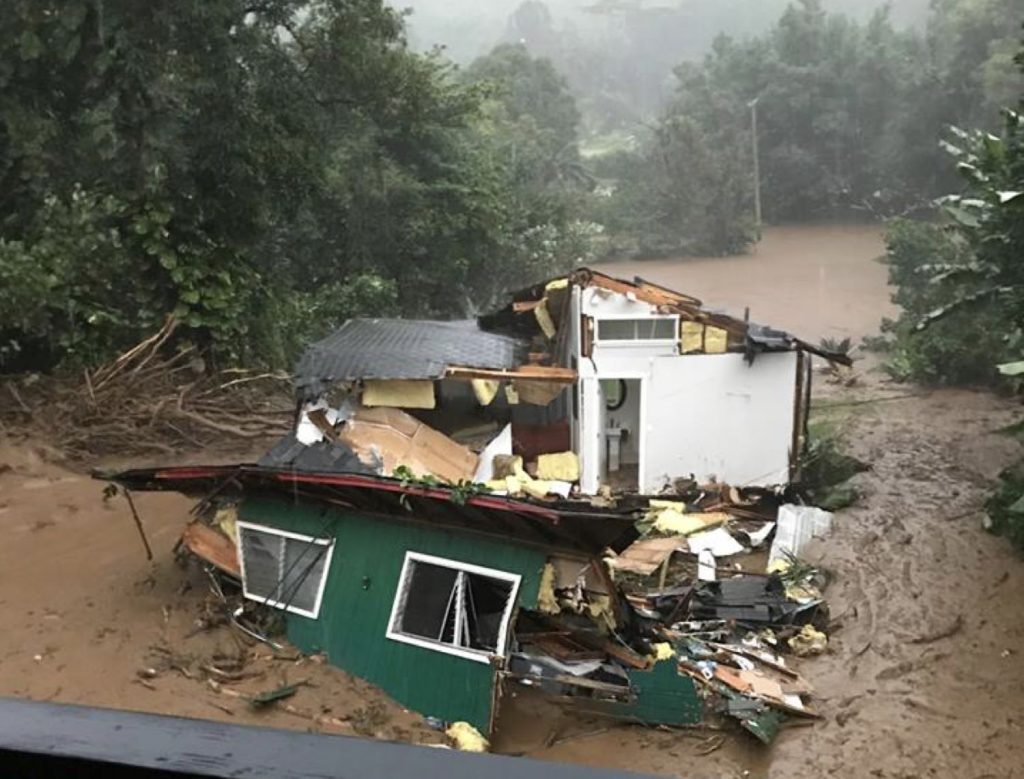
The April 2018 rainstorm inundated some areas of Kauaʻi with nearly 50 inches of rain in a 24-hour period, smashing the previous 24-hour U.S. rainfall record of 42 inches set in 1979 in Texas. The storm caused severe flash flooding and estimated damages of nearly $180 million. The deluge damaged or destroyed 532 homes, and landslides left people along the island’s north coast without access to their homes for months.
Supercell thunderstorms are the least common type of thunderstorm in Hawaiʻi, but they have the greatest likelihood of producing severe weather, including large hail, tornados and strong straight-line winds, said the press release. Another interesting finding in the study is that the rainstorm was associated with a Kona low and not a tropical cyclone, as featured in previous U.S. rainfall records.
Terrence Corrigan, a doctoral candidate and also a member of the Department of Atmospheric Sciences, and Businger sifted through copious weather radar data from the National Weather Service for the study. Their analysis revealed large changes in wind direction and speed in the lower atmosphere.
These shifting winds collided with steep cliffs on the island, triggering thunderstorms with rotating updrafts. Data shows that the scale of rotation and strength of rainfall are consistent with supercell thunderstorms.
“Updrafts with rotation are more intense and longer lived, and have been observed to produce large hail and tornadoes in Hawaiʻi,” Businger said in the press release. “In this case, the updrafts were forced by Kauaʻi’s steep mountain cliffs, with the result that the thunderstorms were more vigorous and anchored to the terrain, thus setting a new U.S. 24-hour rainfall record!”
Businger and Corrigan’s next steps are to use high resolution computer models to simulate the interaction between various wind flows and terrain configurations to further shed light on the interaction of mountains and severe thunderstorms.
“Understanding the dynamic interaction of our tropical atmosphere and steep mountains will help weather forecasters better anticipate severe weather events and flash floods in our state and elsewhere,” Businger said in the release.
