

Despite the recent dryness, all of the rain gages on Kaua‘i continued to have near to above average rainfall totals for 2020 through the end of August, the National Weather Service (NWS) reports.
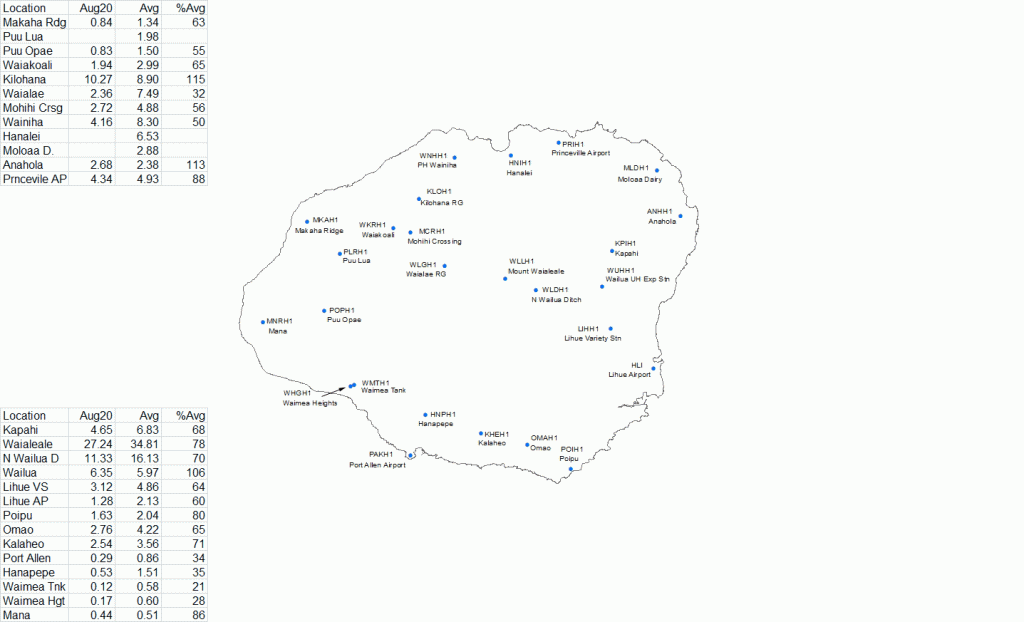
Most of the August rainfall totals were below average. The US Geological Survey’s (USGS) rain gage on Mount Waialeale had the highest monthly total of 27.24 inches (78% of average) and the highest daily total of 2.18 inches on Aug. 7.
While the August totals were mostly below average, Kaua‘i overall has managed to avoid the significant dryness being observed in other parts of the state this summer. The Mount Waialeale gage had the highest year-to-date total of 306.88 inches (117% of average).
Trade wind conditions statewide prevailed through the month of August with no breaks, NWS reported.
“The trades were even more persistent than in July, which had a couple of short-lived disruptions such as the passage of Hurricane Douglas just north of the state,” according to NWS.
Although the trades were persistent, the atmosphere was generally quite stable through the month which resulted in below-average rainfall in many areas, even along the windward slopes. The most significant rain event of the month occurred on Aug. 6 and 7 when an upper level disturbance helped destabilize the atmosphere, resulting in enhanced trade wind showers along the windward slopes. Daily totals of just over 2 inches occurred at a handful of sites statewide and there were no reports of flooding issues.
Another upper level disturbance in combination with an area of deep tropical moisture moved westward across the island chain on Aug. 19 and 20. However, heavy showers failed to materialize and there were no rainfall totals greater than an inch.
One notable aspect of the regional weather pattern was the lack of tropical cyclone activity, NWS reported. August is historically the most active month for tropical cyclones in the central North Pacific basin with a long-term average of one to two systems. However, there were no tropical cyclones during the entire month, leaving the 2020 season count at two, a system in June and another one in July.
